. .  
AFGHANISTAN INDEX
MAIN INDEX
Country Ranks
Country Photos
|
 
Afghanistan Photos
https://theodora.com/wfb/photos/afghanistan/afghanistan_photos_00.html
SOURCE: Embassy of Afghanistan, Washington
Alphabetical index of photos of Afghanistan below the thumbnail index.


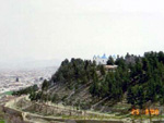


Aerial view of Kabul
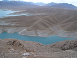
Amir lake (Band-e-Amir), Bamyan province
Ahmad Shah Durani tomb in Kandahar
Baba Saab mosque, Kandahar province
Bagh-e-Bala, Kabul
Bamyan lakes region, Bamyan province
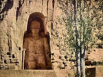
Bamiyan Buddha statue before its destruction
Bamiyan Buddha statue before its destruction
Bamiyan Buddha statue before its destruction
Destruction of a Bamyan Buddha statue
Band-e-Amir National Park, Bamyan province
Bamyan valley
Band Amir
Band Amir
Band Amir
Dara
Eastern Afghanistan
Friday (Jumah) mosque, Herat
Helmand river, Helmand province
Herat
Herat towers
Khoshi valley
Mazar-e-Sharif mosque
Mosque in Herat
Mosque in Herat
Kabul
Kabul
Kabul
Kabul
Kandahar
Mazar-e-Sharif Mosque
Mountains
Northwest Afghanistan
Puli-i-Alam, Logar province
Saw bridge, Kunar province
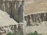
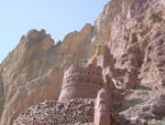
Shahr-i-Zohok (Red Ciry), Bamyan province
Shahr-i-Zohok (Red Ciry) tower, Bamyan province
Shell of 'Large Buddha' and surrounding caves, Bamyan province
|
|
NOTE: The information regarding Cambodia on this page is re-published from the World Fact Book of the Royal Government of Cambodia. No claims are made regarding the accuracy of Cambodia Photos information contained here. All suggestions for corrections of any errors about Cambodia Photos should be addressed to the Royal Government of Cambodia.
|


