
The surface of the Earth is approximately 70.9% water and 29.1% land. The former portion constitutes the World Ocean, the single largest feature of the planet and one that connects all places on the globe. The World Ocean is divided by the intervening continental landmasses into five major ocean basins, which are in decreasing order of size: the Pacific, Atlantic, Indian, Southern, and Arctic. The World Factbook describes each of these five as oceans. Given the significant differences in direction and temperature of major ocean currents, as well as the effects of the major air masses above them, the Pacific and Atlantic Oceans are generally divided at the equator into the North and South Pacific Oceans and the North and South Atlantic Oceans, thus creating seven major water bodies - the so-called "Seven Seas."
Some 97.5% of the Earth's water is saltwater. Of the 2.5% that is fresh, about two-thirds is frozen mostly locked up in the Antarctic ice sheets and mountain glaciers worldwide. If all the surface ice on earth fully melted, the sea level would rise about 70 m (230 ft).
In a 100-year period, a water molecule spends 98 years in the ocean, 20 months as ice, about two weeks in lakes and rivers, and less than a week in the atmosphere. Groundwater can take 50 years to just traverse 1 km (0.6 mi).
Earth's land portion is generally divided into several, large, discrete landmasses termed continents. Depending on the convention used, the number of continents can vary from five to seven. The most common classification recognizes seven, which are (from largest to smallest): Asia, Africa, North America, South America, Antarctica, Europe, and Australia. Asia and Europe are sometimes lumped together into a Eurasian continent resulting in six continents. Alternatively, North and South America are sometimes grouped as simply the Americas, resulting in a continent total of six (or five, if the Eurasia designation is used).
North America is commonly understood to include the island of Greenland, the isles of the Caribbean, and to extend south all the way to the Isthmus of Panama. The easternmost extent of Europe is generally defined as being the Ural Mountains and the Ural River; on the southeast the Caspian Sea; and on the south the Caucasus Mountains, the Black Sea, and the Mediterranean. Portions of five countries - Azerbaijan, Georgia, Kazakhstan, Russia, and Turkey - fall within both Europe and Asia, but in every instance the larger section is in Asia. These countries are considered part of both continents. Armenia and Cyprus, which lie completely in Western Asia, are geopolitically European countries.
Asia usually incorporates all the islands of the Philippines, Malaysia, and Indonesia. The islands of the Pacific are often lumped with Australia into a "land mass" termed Oceania or Australasia. Africa's northeast extremity is frequently delimited at the Isthmus of Suez, but for geopolitical purposes, the Egyptian Sinai Peninsula is often included as part of Africa.
Although the above groupings are the most common, different continental dispositions are recognized or taught in certain parts of the World, with some arrangements more heavily based on cultural spheres rather than physical geographic considerations.
Based on the seven-continent model, and grouping islands with adjacent continents, Africa has the most countries with 54. Europe contains 49 countries and Asia 48, but these two continents share five countries: Azerbaijan, Georgia, Kazakhstan, Russia, and Turkey. North America consists of 23 sovereign states, Oceania has 16, and South America 12. In total, there are 197 countries recognized by the United States.
countries by continent: Africa (54): Algeria, Angola, Benin, Botswana, Burkina Faso, Burundi, Cabo Verde, Cameroon, Central African Republic, Chad, Comoros, Democratic Republic of the Congo, Republic of the Congo, Cote d'Ivoire, Djibouti, Egypt, Equatorial Guinea, Eritrea, Eswatini, Ethiopia, Gabon, The Gambia, Ghana, Guinea, Guinea-Bissau, Kenya, Lesotho, Liberia, Libya, Madagascar, Malawi, Mali, Mauritania, Mauritius, Morocco, Mozambique, Namibia, Niger, Nigeria, Rwanda, Sao Tome and Principe, Senegal, Seychelles, Sierra Leone, Somalia, South Africa, South Sudan, Sudan, Tanzania, Togo, Tunisia, Uganda, Zambia, Zimbabwe;
Europe (49): Albania, Andorra, Austria, Azerbaijan*, Belarus, Belgium, Bosnia and Herzegovina, Bulgaria, Croatia, Czech Republic, Denmark, Estonia, Finland, France, Georgia*, Germany, Greece, Holy See (Vatican City), Hungary, Iceland, Ireland, Italy, Kazakhstan*, Kosovo, Latvia, Liechtenstein, Lithuania, Luxembourg, Malta, Moldova, Monaco, Montenegro, Netherlands, North Macedonia, Norway, Poland, Portugal, Romania, Russia*, San Marino, Serbia, Slovakia, Slovenia, Spain, Sweden, Switzerland, Turkey*, Ukraine, United Kingdom (* indicates part of the country is also in Asia);
Asia (48): Afghanistan, Armenia, Azerbaijan*, Bahrain, Bangladesh, Bhutan, Brunei, Burma, Cambodia, China, Cyprus, Georgia*, India, Indonesia, Iran, Iraq, Israel, Japan, Jordan, Kazakhstan*, North Korea, South Korea, Kuwait, Kyrgyzstan, Laos, Lebanon, Malaysia, Maldives, Mongolia, Nepal, Oman, Pakistan, Philippines, Qatar, Russia*, Saudi Arabia, Singapore, Sri Lanka, Syria, Tajikistan, Thailand, Timor-Leste, Turkey*, Turkmenistan, United Arab Emirates, Uzbekistan, Vietnam, Yemen (* indicates part of the country is also in Europe);
North America (23): Antigua and Barbuda, The Bahamas, Barbados, Belize, Canada, Costa Rica, Cuba, Dominica, Dominican Republic, El Salvador, Grenada, Guatemala, Haiti, Honduras, Jamaica, Mexico, Nicaragua, Panama, Saint Kitts and Nevis, Saint Lucia, Saint Vincent and the Grenadines, Trinidad and Tobago, United States;
Oceania (16): Australia, Cook Islands, Fiji, Kiribati, Marshall Islands, Federated States of Micronesia, Nauru, New Zealand, Niue, Palau, Papua New Guinea, Samoa, Solomon Islands, Tonga, Tuvalu, Vanuatu;
South America (12): Argentina, Bolivia, Brazil, Chile, Colombia, Ecuador, Guyana, Paraguay, Peru, Suriname, Uruguay, Venezuela.
Three of the states described above – France, Netherlands, and the United Kingdom – consist of smaller political entities that are referred to as countries. France considers French Polynesia an overseas country; the Kingdom of the Netherlands refers to all four of its constituent parts (Netherlands [proper], and the islands of Aruba, Curacao, and Sint Maarten) as countries; and the United Kingdom comprises the countries of England, Wales, Scotland, and Northern Ireland. While not recognized as sovereign states, The World Factbook does include descriptive entries for the French and Dutch island "countries."
the World from space: Earth is the only planet in the Solar System to have water in its three states of matter: liquid (oceans, lakes, and rivers), solid (ice), and gas (water vapor in clouds). From a distance, Earth would be the brightest of the eight planets in the Solar System; this luminous effect would be because of the sunlight reflected by the planet's water.
Earth is also the only planet in the Solar System known to be active with earthquakes and volcanoes due to plate tectonics; these events form the landscape, replenish carbon dioxide into the atmosphere, and erase impact craters caused by meteors.
Earth has a slight equatorial bulge - a difference between its equatorial and polar diameters - because of the centrifugal force exerted by the rotation of the planet about its axis. The equatorial diameter is 12,756 km, but the polar diameter is 12,714 km; this results in the Earth's circumference at the equator being 40,075 km, while the polar circumference is 40,008 km.
the physical World: The Earth is composed of three layers: the outer lithosphere (with its crust and uppermost solid mantle), the mantle (the thickest layer, with distinct upper and lower layers), and the core (with an outer (liquid) and inner (solid) core). Researchers have discovered that a transition zone (at a depth of 410-660 km (255-410 mi)) between the upper and lower mantle may well be hydrous (water-bearing). But this hydrous rock would neither feel wet nor drip water. At that depth, high temperatures and pressures structurally transform a mineral called olivine into another mineral ringwoodite - and ringwoodite can incorporate water, but not water in a liquid, solid, or gas form. The high temperatures and pressures cause: 1) water molecules to split, creating hydroxide ions (hydrogen and oxygen atoms bound together), and 2) create structural changes in ringwoodite so that it is able to contain hydroxide ions. Ringwoodite can hold 1 to 3% of its weight in hydroxide ions. Considering that the 250 km-transition zone is about 7% of the Earth's mass (the crust, by comparison, is only about 1%), it could include at least as much (if not several times more) water than all of the Earth's oceans.
The internal structure of the Earth: 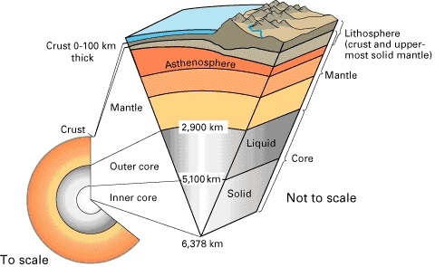
Physical Map of the World
total: 510.072 million sq km
land: 148.94 million sq km
water: 361,899,999 sq km
note: 70.9% of the world's surface is water, 29.1% is land
land area about 16 times the size of the US
Africa-US area comparison map: 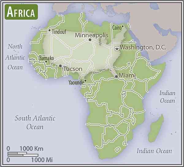 Antarctica-US area comparison map:
 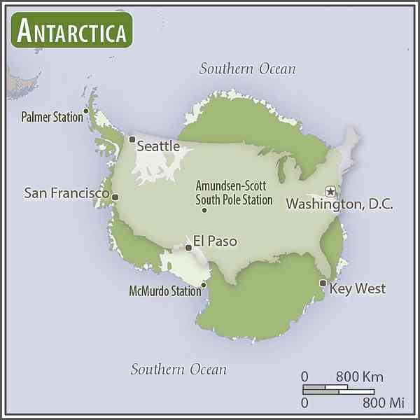 Asia-US area comparison map:
 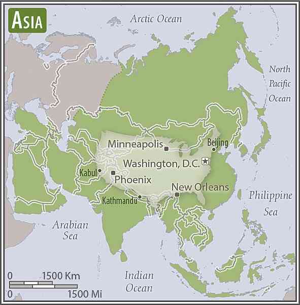 Australia-US area comparison map:
 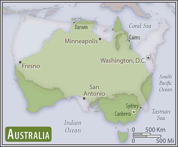 Europe-US area comparison map:
  North America - US area comparison map:
 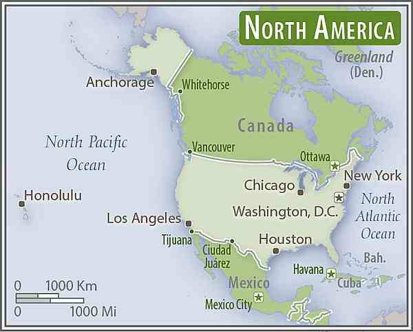 South America-US area comparison map:
top fifteen World Factbook entities ranked by size: Pacific Ocean 155,557,000 sq km; Atlantic Ocean 76,762,000 sq km; Indian Ocean 68,556,000 sq km; Southern Ocean 20,327,000 sq km; Russia 17,098,242 sq km; Antarctica 14,200,000 sq km; Arctic Ocean 14,056,000 sq km; Canada 9,984,670 sq km; United States 9,826,675 sq km; China 9,596,960 sq km; Brazil 8,515,770 sq km; Australia 7,741,220 sq km; European Union 4,324,782 sq km; India 3,287,263 sq km; Argentina 2,780,400 sq km
top ten largest water bodies: Pacific Ocean 155,557,000 sq km; Atlantic Ocean 76,762,000 sq km; Indian Ocean 68,556,000 sq km; Southern Ocean 20,327,000 sq km; Arctic Ocean 14,056,000 sq km; Coral Sea 4,184,100 sq km; South China Sea 3,595,900 sq km; Caribbean Sea 2,834,000 sq km; Bering Sea 2,520,000 sq km; Mediterranean Sea 2,469,000 sq km
top ten largest landmasses: Asia 44,568,500 sq km; Africa 30,065,000 sq km; North America 24,473,000 sq km; South America 17,819,000 sq km; Antarctica 14,200,000 sq km; Europe 9,948,000 sq km; Australia 7,741,220 sq km; Greenland 2,166,086 sq km; New Guinea 785,753 sq km; Borneo 751,929 sq km
top ten largest islands: Greenland 2,166,086 sq km; New Guinea (Indonesia, Papua New Guinea) 785,753 sq km; Borneo (Brunei, Indonesia, Malaysia) 751,929 sq km; Madagascar 587,713 sq km; Baffin Island (Canada) 507,451 sq km; Sumatra (Indonesia) 472,784 sq km; Honshu (Japan) 227,963 sq km; Victoria Island (Canada) 217,291 sq km; Great Britain (United Kingdom) 209,331 sq km; Ellesmere Island (Canada) 196,236 sq km
top ten longest mountain ranges (land-based): Andes (Venezuela, Colombia, Ecuador, Peru, Bolivia, Chile, Argentina) 7,000 km; Rocky Mountains (Canada, US) 4,830 km; Great Dividing Range (Australia) 3,700 km; Transantarctic Mountains (Antarctica) 3,500 km; Kunlun Mountains (China) 3,000 km; Ural Mountains (Russia, Kazakhstan) 2,640 km; Atlas Mountains (Morocco, Algeria, Tunisia) 2,500 km; Appalachian Mountains (Canada, US) 2,400 km; Himalayas (Pakistan, Afghanistan, India, China, Nepal, Bhutan) 2,300 km; Altai Mountains (Kazakhstan, Russia, Mongolia) 2,000 km; note - lengths are approximate; if oceans are included, the Mid-Ocean Ridge is by far the longest mountain range at 40,389 km
top ten largest forested countries (sq km and percent of land): Russia 8,149,310 (49.8%); Brazil 4,935,380 (58.9%); Canada 3,470,690 (38.2%); United States 3,103,700 (33.9%); China 2,098,640 (22.3%); Democratic Republic of the Congo 1,522,670 (67.2%); Australia 1,250,590 (16.3%); Indonesia 903,250 (49.9%); Peru 738,054 (57.7%); India 708,600 (23.8%) (2016 est.)
top ten most densely forested countries (percent of land): Suriname (98.3%), Federated States of Micronesia (91.9%), Gabon (90%), Seychelles (88.4%), Palau (87.6%), Guyana (83.9%), Laos (82.1%), Solomon Islands (77.9%), Papua New Guinea (74.1%), Finland (73.1%) (2016 est.)
top ten largest (non-polar) deserts: Sahara (Algeria, Chad, Egypt, Libya, Mali, Mauritania, Niger, Western Sahara, Sudan, Tunisia) 9,200,000 sq km; Arabian (Saudi Arabia, Iraq, Jordan, Kuwait, Oman, Qatar, United Arab Emirates, Yemen) 2,330,000 sq km; Gobi (China, Mongolia) 1,295,000 sq km; Kalahari (Botswana, Namibia, South Africa) 900,000 sq km; Patagonian (Argentina) 673,000 sq km; Syrian (Syria, Iraq, Jordan, Saudi Arabia) 500,000 sq km; Chihuahuan (Mexico) 362,000 sq km; Kara-Kum (Turkmenistan) 350,000 sq km; Great Victoria (Australia) 348,750 sq km; Great Basin (United States) 343,169 sq km; note - if the two polar deserts are included, they would rank first and second: Antarctic Desert 14,200,000 sq km and Arctic Desert 13,900,000 sq km
ten smallest independent countries: Holy See (Vatican City) 0.44 sq km; Monaco 2 sq km; Nauru 21 sq km; Tuvalu 26 sq km; San Marino 61 sq km; Liechtenstein 160 sq km; Marshall Islands 181 sq km; Cook Islands 236 sq km; Niue 260 sq km; Saint Kitts and Nevis 261 sq km
the land boundaries in The World Factbook total 279,035.5 km (not counting shared boundaries twice); two nations, China and Russia, each border 14 other countries
note 1: the total is actually misleading in terms of accuracy, since one cannot accurately measure every river meander along a boundary; a number rounded slightly higher - to 280,000 km - makes more sense and has been coordinated with and approved by the US State Department
note 2: 46 nations and other areas are landlocked, these include: Afghanistan, Andorra, Armenia, Austria, Azerbaijan, Belarus, Bhutan, Bolivia, Botswana, Burkina Faso, Burundi, Central African Republic, Chad, Czechia, Eswatini, Ethiopia, Holy See (Vatican City), Hungary, Kazakhstan, Kosovo, Kyrgyzstan, Laos, Lesotho, Liechtenstein, Luxembourg, Macedonia, Malawi, Mali, Moldova, Mongolia, Nepal, Niger, Paraguay, Rwanda, San Marino, Serbia, Slovakia, South Sudan, Switzerland, Tajikistan, Turkmenistan, Uganda, Uzbekistan, West Bank, Zambia, Zimbabwe; two of these, Liechtenstein and Uzbekistan, are doubly landlocked
note 3: worldwide, some one-quarter of interior (non-coastal) borders are rivers; South America with 43% leads the continents, followed by North America with 32%, Africa with 30%, Europe with 23%, and Asia with 18%; Australia has no interior national river borders
356,000 km
note: 95 nations and other entities are islands that border no other countries, they include: American Samoa, Anguilla, Antigua and Barbuda, Aruba, Ashmore and Cartier Islands, The Bahamas, Bahrain, Baker Island, Barbados, Bermuda, Bouvet Island, British Indian Ocean Territory, British Virgin Islands, Cabo Verde, Cayman Islands, Christmas Island, Clipperton Island, Cocos (Keeling) Islands, Comoros, Cook Islands, Coral Sea Islands, Cuba, Curacao, Cyprus, Dominica, Falkland Islands (Islas Malvinas), Faroe Islands, Fiji, French Polynesia, French Southern and Antarctic Lands, Greenland, Grenada, Guam, Guernsey, Heard Island and McDonald Islands, Howland Island, Iceland, Isle of Man, Jamaica, Jan Mayen, Japan, Jarvis Island, Jersey, Johnston Atoll, Kingman Reef, Kiribati, Madagascar, Maldives, Malta, Marshall Islands, Mauritius, Mayotte, Federated States of Micronesia, Midway Islands, Montserrat, Nauru, Navassa Island, New Caledonia, New Zealand, Niue, Norfolk Island, Northern Mariana Islands, Palau, Palmyra Atoll, Paracel Islands, Philippines, Pitcairn Islands, Puerto Rico, Saint Barthelemy, Saint Helena, Saint Kitts and Nevis, Saint Lucia, Saint Pierre and Miquelon, Saint Vincent and the Grenadines, Samoa, Sao Tome and Principe, Seychelles, Singapore, Sint Maarten, Solomon Islands, South Georgia and the South Sandwich Islands, Spratly Islands, Sri Lanka, Svalbard, Taiwan, Tokelau, Tonga, Trinidad and Tobago, Turks and Caicos Islands, Tuvalu, Vanuatu, Virgin Islands, Wake Island, Wallis and Futuna
a variety of situations exist, but in general, most countries make the following claims measured from the mean low-tide baseline as described in the 1982 UN Convention on the Law of the Sea: territorial sea - 12 nm, contiguous zone - 24 nm, and exclusive economic zone - 200 nm; additional zones provide for exploitation of continental shelf resources and an exclusive fishing zone; boundary situations with neighboring states prevent many countries from extending their fishing or economic zones to a full 200 nm
a wide equatorial band of hot and humid tropical climates, bordered north and south by subtropical temperate zones that separate two large areas of cold and dry polar climates
ten driest places on Earth (average annual precipitation): McMurdo Dry Valleys, Antarctica 0 mm (0 in)
Arica, Chile 0.76 mm (0.03 in)
Al Kufrah, Libya 0.86 mm (0.03 in)
Aswan, Egypt 0.86 mm (0.03 in)
Luxor, Egypt 0.86 mm (0.03 in)
Ica, Peru 2.29 mm (0.09 in)
Wadi Halfa, Sudan 2.45 mm (0.1 in)
Iquique, Chile 5.08 mm (0.2 in)
Pelican Point, Namibia 8.13 mm (0.32 in)
El Arab (Aoulef), Algeria 12.19 mm (0.48 in)
ten wettest places on Earth (average annual precipitation): Mawsynram, India 11,871 mm (467.4 in)
Cherrapunji, India 11,777 mm (463.7 in)
Tutunendo, Colombia 11,770 mm (463.4 in)
Cropp River, New Zealand 11,516 mm (453.4 in)
San Antonia de Ureca, Equatorial Guinea 10,450 mm (411.4 in)
Debundsha, Cameroon 10,299 mm (405.5 in)
Big Bog, US (Hawaii) 10,272 mm (404.4 in)
Mt Waialeale, US (Hawaii) 9,763 mm (384.4 in)
Kukui, US (Hawaii) 9,293 mm (365.9 in)
Emeishan, China 8,169 mm (321.6 in)
ten coldest places on Earth (lowest average monthly temperature): Verkhoyansk, Russia (Siberia) -47°C (-53°F) January
Oymyakon, Russia (Siberia) -46°C (-52°F) January
Eureka, Canada -38.4°C (-37.1°F) February
Isachsen, Canada -36°C (-32.8°F) February
Alert, Canada -34°C (-28°F) February
Kap Morris Jesup, Greenland -34°C (-29°F) March
Cornwallis Island, Canada -33.5°C (-28.3°F) February
Cambridge Bay, Canada -33.5°C (28.3°F) February
Ilirnej, Russia -33°C (-28°F) January
Resolute, Canada -33°C (-27.4°F) February
ten hottest places on Earth (highest average monthly temperature): Death Valley, US (California) 39°C (101°F) July
Iranshahr, Iran 38.3°C (100.9°F) June
Ouallene, Algeria 38°C (100.4°F) July
Kuwait City, Kuwait 37.7°C (100°F) July
Medina, Saudi Arabia 36°C (97°F) July
Buckeye, US (Arizona) 34°C (93°F) July
Jazan, Saudi Arabia 33°C (91°F) June
Al Kufrah, Libya 31°C (87°F) July
Alice Springs, Australia 29°C (84°F) January
Tamanrasset, Algeria 29°C (84°F) June
tremendous variation of terrain may be found on each of the continents; check the World "Elevation" entry for a compilation of terrain extremes; the world's ocean floors also display extraordinary variation while the ocean surfaces form a dynamic, continuously changing environment; check the "Bathymetry" and "Major surface currents" entries under each of the five ocean entries (Arctic, Atlantic, Indian, Pacific, and Southern) for further information on oceanic environs
Ten Cave Superlatives: compiled from "Geography - note(s)" under various country entries where more details may be found
largest cave: Son Doong in Phong Nha-Ke Bang National Park, Vietnam is the World's largest cave (greatest cross sectional area) and is the largest known cave passage in the world by volume; it currently measures a total of 38.5 million cu m (about 1.35 billion cu ft); it connects to Thung cave (but not yet officially); when recognized, it will add an additional 1.6 million cu m in volume
largest ice cave: the Eisriesenwelt (Ice Giants World) inside the Hochkogel mountain near Werfen, Austria is the World's largest and longest ice cave system at 42 km (26 mi)
longest cave: Mammoth Cave, in west-central Kentucky, is the World's longest known cave system with more than 650 km (405 mi) of surveyed passageways
longest salt cave: the Malham Cave in Mount Sodom in Israel is the World's longest salt cave at 10 km (6 mi); its survey is not complete and its length will undoubtedly increase
longest underwater cave: the Sac Actun cave system in Mexico at 348 km (216 mi) is the longest underwater cave in the World and the second longest cave worldwide
longest lava tube cave: Kazumura Cave on the island of Hawaii is the World's longest and deepest lava tube cave; it has been surveyed at 66 km (41 mi) long and 1,102 m (3,614 ft) deep
deepest cave: Veryovkina Cave in the Caucasus country of Georgia is the World's deepest cave, plunging down 2,212 m (7,257 ft)
deepest underwater cave: the Hranice Abyss in Czechia is the World's deepest surveyed underwater cave at 404 m (1,325 ft); its survey is not complete and it could end up being some 800-1,200 m deep
largest cave chamber: the Miao Room in the Gebihe cave system at China's Ziyun Getu He Chuandong National Park encloses some 10.78 million cu m (380.7 million cu ft) of volume
largest bat cave: Bracken Cave outside of San Antonio, Texas is the World's largest bat cave; it is the summer home to the largest colony of bats in the World; an estimated 20 million Mexican free-tailed bats roost in the cave from March to October making it the World's largest known concentration of mammals
bonus "cave" - the world's largest sinkhole: the Xiaoxhai Tiankeng sinkhole in Chongqing Municipality, China is 660 m deep, with a volume of 130 million cu m
highest point: Mount Everest 8,849 m
lowest point: Denman Glacier (Antarctica) more than -3,500 m (in the oceanic realm, Challenger Deep in the Mariana Trench is the lowest point, lying -10,924 m below the surface of the Pacific Ocean)
mean elevation: 840 m
top ten highest mountains (measured from sea level): Mount Everest (China-Nepal) 8,849 m; K2 (Pakistan) 8,611 m; Kanchenjunga (India-Nepal) 8,598 m; Lhotse (Nepal) 8,516 m; Makalu (China-Nepal) 8,463 m; Cho Oyu (China-Nepal) 8,201 m; Dhaulagiri (Nepal) 8,167 m; Manaslu (Nepal) 8,163 m; Nanga Parbat (Pakistan) 8,125 m; Anapurna (Nepal) 8,091 m; note - Mauna Kea (United States) is the world's tallest mountain as measured from base to summit; the peak of this volcanic colossus lies on the island of Hawaii, but its base begins more than 70 km offshore and at a depth of about 6,000 m; total height estimates range from 9,966 m to 10,203 m
top ten highest island peaks: Puncak Jaya (New Guinea) 4,884 m (Indonesia)*; Mauna Kea (Hawaii) 4,207 m (United States); Gunung Kinabalu (Borneo) 4,095 m (Malaysia)*; Yu Shan (Taiwan) 3,952 (Taiwan)*; Mount Kerinci (Sumatra) 3,805 m (Indonesia); Mount Erebus (Ross Island) 3,794 (Antarctica); Mount Fuji (Honshu) 3,776 m (Japan)*; Mount Rinjani (Lombok) 3,726 m (Indonesia); Aoraki-Mount Cook (South Island) 3,724 m (New Zealand)*; Pico de Teide (Tenerife) 3,718 m (Spain)*; note - * indicates the highest peak for that Factbook entry
highest point on each continent: Asia - Mount Everest (China-Nepal) 8,849 m; South America - Cerro Aconcagua (Argentina) 6,960 m; North America - Denali (Mount McKinley) (United States) 6,190 m; Africa - Kilimanjaro (Tanzania) 5,895 m; Europe - El'brus (Russia) 5,633 m; Antarctica - Vinson Massif 4,897 m; Australia - Mount Kosciuszko 2,229 m
highest capital on each continent: South America - La Paz (Bolivia) 3,640 m; Africa - Addis Ababa (Ethiopia) 2,355 m; Asia - Thimphu (Bhutan) 2,334 m; North America - Mexico City (Mexico) 2,240 m; Europe - Andorra la Vella (Andorra) 1,023 m; Australia - Canberra (Australia) 605 m
lowest point on each continent: Antarctica - Denman Glacier more than -3,500 m; Asia - Dead Sea (Israel-Jordan) -431 m; Africa - Lac Assal (Djibouti) -155 m; South America - Laguna del Carbon (Argentina) -105 m; North America - Death Valley (United States) -86 m; Europe - Caspian Sea (Azerbaijan-Kazakhstan-Russia) -28 m; Australia - Lake Eyre -15
lowest capital on each continent: Asia - Baku (Azerbaijan) -28 m; Europe - Amsterdam (Netherlands) -2 m; Africa - Banjul (Gambia); Bissau (Guinea-Bissau), Conakry (Guinea), Djibouti (Djibouti), Libreville (Gabon), Male (Maldives), Monrovia (Liberia), Tunis (Tunisia), Victoria (Seychelles) 0 m; North America - Basseterre (Saint Kitts and Nevis), Kingstown (Saint Vincent and the Grenadines), Panama City (Panama), Port of Spain (Trinidad and Tobago), Roseau (Dominica), Saint John's (Antigua and Barbuda), Santo Domingo (Dominican Republic) 0 m; South America - Georgetown (Guyana) 0 m; Australia - Canberra (Australia) 605 m
the rapid depletion of nonrenewable mineral resources, the depletion of forest areas and wetlands, the extinction of animal and plant species, and the deterioration in air and water quality pose serious long-term problems
3,242,917 sq km (2012 est.)
top ten largest natural lakes: Caspian Sea (Azerbaijan, Iran, Kazakhstan, Russia, Turkmenistan) 374,000 sq km; Lake Superior (Canada, United States) 82,100 sq km; Lake Victoria (Kenya, Tanzania, Uganda) 62,940 sq km; Lake Huron (Canada, United States) 59,600 sq km; Lake Michigan (United States) 57,750 sq km; Lake Tanganyika (Burundi, Democratic Republic of the Congo, Tanzania, Zambia) 32,000 sq km; Great Bear Lake (Canada) 31,328 sq km; Lake Baikal (Russia) 31,500 sq km; Lake Malawi (Malawi, Mozambique, Tanzania) 22,490 sq km; Great Slave Lake (Canada) 28,568 sq km
note 1: the areas of the lakes are subject to seasonal variation; only the Caspian Sea is saline, the rest are fresh water
note 2: Lakes Huron and Michigan are technically a single lake because the flow of water between the Straits of Mackinac that connects the two lakes keeps their water levels at near-equilibrium; combined, Lake Huron-Michigan is the largest freshwater lake by surface area in the World
note 3: if ranked by water volume, the Caspian Sea would still be first, but it would be followed Lakes Baikal, Tanganyika, Superior, and Malawi; Lake Superior contains more water than the other four North American Great Lakes (Erie, Huron, Michigan, Ontario) combined
top ten longest rivers: Nile (Africa) 6,650 km; Amazon (South America) 6,436 km; Yangtze (Asia) 6,300 km; Mississippi-Missouri (North America) 6,275 km; Yenisey-Angara (Asia) 5,539 km; Huang He/Yellow (Asia) 5,464 km; Ob-Irtysh (Asia) 5,410 km; Congo (Africa) 4,700 km; Amur (Asia) 4,444 km; Lena (Asia) 4,400 km
note: there are 21 countries without rivers: 3 in Africa (Comoros, Djibouti, Libya), 1 in the Americas (Bahamas), 8 in Asia (Bahrain, Kuwait, Maldives, Oman, Qatar, Saudi Arabia, United Arab Emirates, Yemen), 3 in Europe (Malta, Monaco, Holy See), 6 in Oceania (Kiribati, Marshall Islands, Nauru, Niue, Tonga, Tuvalu); these countries also do not have natural lakes
summary statement: a watershed is a drainage basin on an area of land where precipitation collects and drains off into a common outlet, such as into a river, bay, or other body of water; oceans ultimately take in the drainage from 83% of all land area; the remaining 17% of the land drains into internal (endorheic) basins, e.g., the Caspian Sea; The World Factbook lists 51 different watersheds across 102 countries; of these, 18 are in Asia, 9 in Europe, 9 in Africa, 8 in North and Central America, 5 in South America, and 2 in Australia; all watersheds with an area of at least 500,000 sq km have been included along with a number of smaller, regionally significant watersheds; together, these watersheds represent the surface hydrology water flows that are the World's primary sources of fresh water for individual consumption, industry, and agriculture
summary statement: aquifers are underground layers of water-bearing permeable rock formations; they include alluvial formations such as unconsolidated sand and gravel aquifers, sedimentary rock formations of sandstone and karst (carbonate rocks such as limestone) aquifers, as well as volcanic aquifers, and basement aquifers (igneous and metamorphic rocks that underlie sedimentary and volcanic rock sequences); groundwater from aquifers can be extracted using a water well; The World Factbook lists 37 major aquifers across 52 countries; of these, 13 are in Africa, 10 in Asia, 5 in North America, 3 in South America, 4 in Europe, and 2 in Australia; although aquifers can vary in size, the major aquifers listed in The Factbook contain the bulk of the stored volume of groundwater; the fresh water held in these aquifers represents more than 30% of the World's fresh water; in the US, groundwater is primarily used for irrigation and globally, 70% of groundwater withdrawn is used for agriculture; groundwater also supplies almost half of all drinking water worldwide
six of the world's seven continents are widely and permanently inhabited; Asia is easily the most-populous continent with about 60% of the world's population (China and India together account for over 35%); Africa comes in second with over 15% of the earth's populace, Europe has about 10%, North America 8%, South America almost 6%, and Oceania less than 1%; the harsh conditions on Antarctica prevent any permanent habitation
large areas subject to severe weather (tropical cyclones); natural disasters (earthquakes, landslides, tsunamis, volcanic eruptions)
volcanism: volcanism is a fundamental driver and consequence of plate tectonics, the physical process reshaping the Earth's lithosphere; the World is home to more than 1,500 potentially active volcanoes, with over 500 of these having erupted in historical times; an estimated 500 million people live near these volcanoes; associated dangers include lava flows, lahars (mudflows), pyroclastic flows, ash clouds, ash fall, ballistic projectiles, gas emissions, landslides, earthquakes, and tsunamis; in the 1990s, the International Association of Volcanology and Chemistry of the Earth's Interior, created a list of 16 Decade Volcanoes worthy of special study because of their great potential for destruction: Avachinsky-Koryaksky (Russia), Colima (Mexico), Etna (Italy), Galeras (Colombia), Mauna Loa (United States), Merapi (Indonesia), Nyiragongo (Democratic Republic of the Congo), Rainier (United States), Sakurajima (Japan), Santa Maria (Guatemala), Santorini (Greece), Taal (Philippines), Teide (Spain), Ulawun (Papua New Guinea), Unzen (Japan), Vesuvius (Italy); see second note under "Geography - note"
Volcano statistics and superlatives:
countries with the most volcanoes (Holocene Epoch, the past 12,000 years): United States (162), Japan (122), Indonesia (120), Russia (117), Chile (91); note - roughly 1,350 volcanoes have erupted over this time period; about 40-50 eruptions are ongoing at any one time; the frequency of volcanoes has not increased
longest erupting volcano: Santa Maria volcano in Guatemala has been constantly erupting since 22 June 1922; note - the Yasur volcano on Tanna Island in Vanuatu was observed to be erupting by Captain Cook in 1774 and has been in constant activity since then, but it is not cited since it has no clear start date; research (tephra stratigraphy and radiocarbon dating) shows that activity may have begun on Yasur ca. A.D. 1270 and so has persisted for over 750 years
highest volcano (above sea level): Nevado Ojos del Salado (6,893 m; 22,615 ft) on the Chile-Argentina border is the World's highest volcano above sea level and the highest peak in Chile
highest volcano (from base): Mauna Kea (United States) is the World's tallest mountain as measured from base to summit; the peak of this volcanic colossus lies on the island of Hawaii, but its base begins more than 70 km offshore and at a depth of about 6,000 m; total height estimates range from 9,966 m to 10,203 m
The Seven Wonders of the Ancient World:
The conquests of Alexander the Great (r. 336-323 B.C.) in the fourth century B.C. fostered the spread of Greek culture to the lands bordering the eastern Mediterranean and through much of the Middle East, ushering in what is today referred to as the Hellenistic Period (323-31 B.C.). Guidebooks compiled by Hellenistic sightseers focused on outstanding monuments in those parts of the world now brought into the Hellenistic sphere: Persia, Egypt, and Babylon. Generally, seven were emphasized since that number was considered magical, perfect, and complete. Not all Wonders lists from ancient times agreed completely, but generally six of the seven consistently appeared (the massive Walls of Babylon sometimes substituted for the Lighthouse of Alexandria). The seven described below represent the “classic” Seven Wonders most often cited.
1. 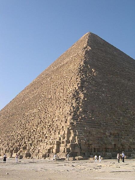
The oldest of the Seven Wonders, the Great Pyramid is the only one that remains largely intact. Commissioned by the Pharaoh Khufu (r. ca. 2589-2566 B.C.), it is the largest of the three pyramids at Giza. It served as the ruler’s tomb and was built over a period of some 20 years, concluding about 2560 B.C. Estimated to have been 146.5 m tall when completed, it was the tallest man-made structure in the world for over 3,800 years (until the 14th century A.D.). Most of the original limestone casing stones that formed the outer smooth surface of the pyramid are gone. Today, the pyramid’s height is about 139 m.
2. The Hanging Gardens of Babylon
This is the only one of the ancient Seven Wonders for which a definitive location has never been established. There are no surviving Babylonian texts mentioning the Gardens, nor have any archeological remains ever been discovered in today’s Iraq. According to tradition, the Gardens were a remarkable feat of engineering with an ascending series of mud-brick-tiered gardens containing a variety of trees, shrubs, and vines that when viewed from below resembled a leafy green mountain. The Gardens are frequently attributed to the Neo-Babylonian King Nebuchadnezzar II (r. 605-562 B.C.), who had them built for his Median wife Queen Amytis, who missed the green hills and valleys of her homeland.
3. The Temple of Artemis (Artemision) at Ephesus
This Greek temple at Ephesus (3 km southwest of Selcuk in present-day western Turkey), dedicated to the goddess Artemis, was completely rebuilt twice: once after a 7th century B.C. flood and then following a 356 B.C. act of arson. In its final form it was judged to be one of the Seven Wonders and it survived for 600 years. The magnificent building was composed entirely of marble. Its massive dimensions were reported as 130 m by 69 m, with 127 columns, each some 18 m tall. The Temple was damaged in a Gothic raid in A.D. 268 and finally closed by Christians in the early-to-mid 5th century. The structure was dismantled in succeeding centuries and today almost nothing of the Temple remains.
4. The Mausoleum of Halicarnassus
Constructed in about 350 B.C., the Mausoleum of Halicarnassus was located on the site of the present-day city of Bodrum in southwestern Turkey. It was the tomb of Mausolus, a Persian ruler, and his wife. (It is from the ruler’s name that the term mausoleum is derived.) The structure stood about 45 m high and took some 20 years to complete. A series of earthquakes between the 12th and 15th centuries A.D. devastated the structure, the last of the original Seven Wonders to be destroyed.
5. The Colossus of Rhodes
This statue of the Greek sun god Helios, constructed to celebrate Rhodes’ successful repulse of a siege, was made of iron tie bars to which brass or bronze plates were attached to form a skin. Contemporary descriptions list its height at about 70 cubits or some 33 m – approximately the same height as the Statue of Liberty from heel to top of head (34 m) – thus making it the tallest statue in the ancient world. Completed in about 280 B.C. at the entrance to Rhodes harbor, the monument only stood for approximately 54 years until it toppled in a 226 B.C. earthquake. The impressive remains lay on the ground for over 800 years before finally being sold for scrap.
6. The Lighthouse (Pharos) of Alexandria
Completed around 275 B.C., the Alexandria Lighthouse stood on Pharos Island at the entrance to the Egyptian port city for some 1,600 years! It was severely damaged by three earthquakes between A.D. 956 and 1323, when it was deactivated. We have a fairly good idea of the shape of the structure since it appears on a number of ancient coins. A solid square base, which made up about half of the height, supported an octagonal middle section, and a cylindrical top. The height of the structure is thought to have been at least 100 m and perhaps as high as 140 m. (The tallest lighthouse in the world today is the Jeddah Light in Saudi Arabia, which stands at 133 m.) At its apex stood a mirror that reflected sunlight during the day; a fire burned at night. Since it could be seen at a very great distance, the Pharos light served as a reassuring beacon for mariners from all parts of the Mediterranean.
7. The Statue of Zeus at Olympia in Greece
The giant seated statue of the king of the Greek gods in the sanctuary of Olympia was completed by the Greek sculptor Phidias in approximately 435 B.C. Roughly 13 m tall, it was constructed of ivory plates and gold panels on a wooden framework; the god’s throne was ornamented with ebony, ivory, gold, and precious stones. With the rise of Christianity, the sanctuary at Olympia fell into disuse; the details of the statue’s final destruction are unknown.
note: The Lighthouse of Alexandria may have been the last of the Wonders to be completed (ca. 275 B.C.) and the Colossus of Rhodes was the first to be destroyed in about 226 B.C., so the Seven Wonders existed at the same time for only some 50 years in the middle of the third century B.C.
A private initiative to come up with a new list for seven of the world’s wonders sprang up early in the new Millennium. Worldwide balloting – via the Internet or by telephone – took place covering a list of 200 existing monuments. Reportedly over 100 million votes were cast over a period of several years and the final list was announced on 7-7-2007. Even though the polling was unscientific, the seven “winners” were a worthy compilation of extraordinary Wonders to be found around the world. All seven of the New Wonders are inscribed as UNESCO World Heritage Sites and are frequently cited in the literature.
1. 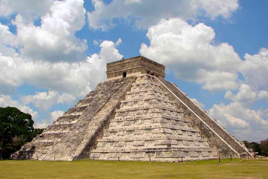 , Yucatan, Mexico
This archeological site includes the impressive remains of a large pre-Columbian Maya city that flourished from ca. A.D. 600-1100. Among the outstanding structures at the site are the massive Temple of the Warriors complex, an Observatory (El Caracol), the Great Ball Court, and the Sacred Cenote (sinkhole) where offerings were made. The most famous building, however, is the step-pyramid known as the Temple of Kukulcan that dominates the center of the site and serves as the symbol of Chichen Itza. The pyramidal structure is 24 m high; the crowning temple adds another 6 m. Although located in the dense jungles of Yucatan, it remains one of the most visited tourist sites in Mexico.
2. 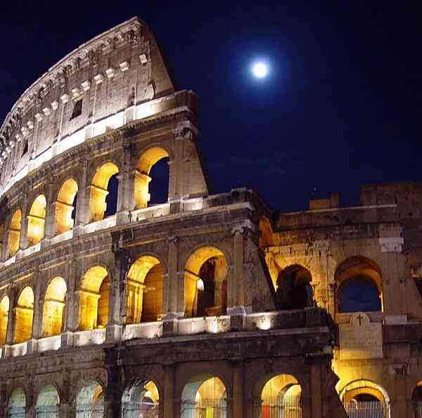 , Rome, Italy
Construction began with the Roman Emperor Vespasian in A.D. 72 and was completed by his son Titus in A.D. 80. Some further modifications were made by Domitian (A.D. 81-96). The three emperors make up the Flavian Dynasty, thus providing the alternate name for the structure as the Flavian Amphitheater. The massive structure is estimated to have seated, on average, about 65 thousand spectators and was most famously used for gladiatorial contests and public spectacles. Substantially ruined by earthquakes and thieves who looted much of the stone, the structure nonetheless remains an iconic symbol of Rome. The Colosseum is one of the most popular tourist attractions in the World.
3. 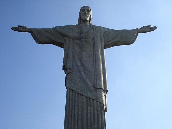 , Rio de Janeiro, Brazil
Built between 1922 and 1931, the 30-meter-tall sculpture is reputed to be the largest Art Deco statue in the World. Its pedestal provides another 8 m in height and the arms stretch out to 28 m. Constructed of reinforced concrete and soapstone, the statue has become the cultural icon not only of Rio but also of Brazil.
4. 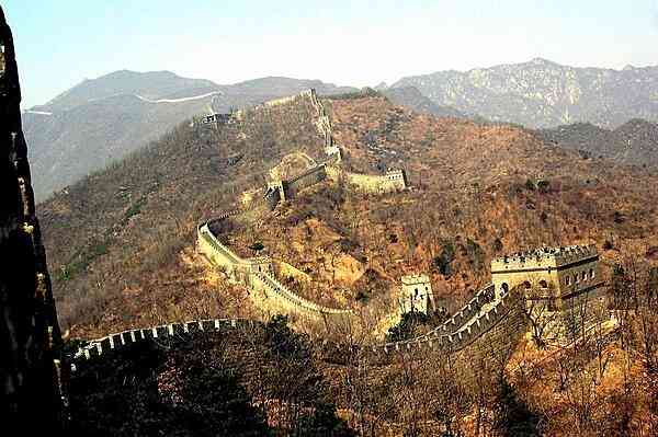 , China
The name refers to a remarkable series of fortification systems that stretched across the northern historical borders of China and served as protection against various nomadic peoples. The earliest of these walls date to the 7th century B.C.; certain stretches began to be linked in the 3rd century B.C. and successive dynasties added to or maintained various sections of the walls. The best known and best-preserved portions of the wall are those built by the Ming Dynasty (1368-1644). An archeological survey revealed that the Wall and all its associated branches measures 21,196 km. Winding through amazingly varied terrain, the Great Wall is acknowledged as one of the most impressive architectural feats in history.
5. 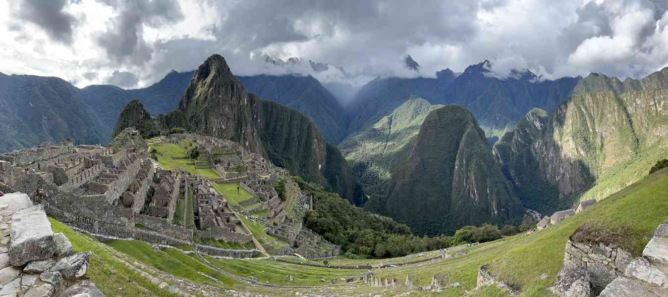 , Cuzco Region, Peru
Perhaps the most spectacular archeological site in the Americas, the Inca citadel of Machu Picchu, situated on a 2,430 m Andean mountain ridge, is now thought to have been erected as an estate for the Inca Emperor Pachacuti (r. 1438-1471). Additionally, it may also have served as a religious sanctuary. Built between about 1450 and 1460, it was abandoned approximately a century later, at the time of the Spanish conquest. Construction was carried out in the classic Inca style of polished, dry-stone, fitted walls. Some 750 people lived at this royal estate, most of them support staff to the nobility. The site is roughly divided into an agricultural sector (with myriad terraces for raising crops) and an urban sector. The latter is composed of an upper town (with temples) and a lower town (with warehouses). Some of the religious monuments include: the Intiwatana (a carved, ritual stone that served as a type of sundial and that is referred to as “The Hitching Post of the Sun”); the Torreon or Temple of the Sun, a small tower that likely served as a type of observatory; and the Intimachay, a sacred cave with a masonry entrance.
6. 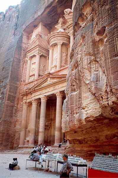 , Ma’an, Jordan
Petra is believed to have been established in the 4th century B.C. as the capital of the Nabataean Kingdom, an entity that grew fabulously wealthy as the nexus of trade routes in the southern Levant. The kingdom retained its independence until annexed by the Roman Empire in A.D. 106. The city is justifiably famous for two things, its stunning rock-cut architecture and its water conduit system, which allowed the Nabataeans to control and store the water supply in this desert region and create an artificial oasis. At its peak in the 1st century A.D., the city may have had a population of 20 thousand.
7. 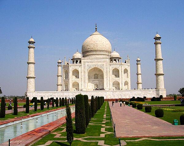 , Agra, Uttar Pradesh, India
This gorgeous ivory-white mausoleum – described as “one of the universally admired masterpieces of the World’s heritage” – was commissioned in 1632 by Shah Jahan (r. 1628-1658) as the final resting place for his favorite wife, Mumtaz Mahal. The building also houses the tomb of Shah Jahan himself. The Taj Mahal is the centerpiece of an entire 17-hectare complex that also includes a guest house, a mosque, and formal gardens. The entire project was not completed until about 1653. The Taj Mahal remains one of the most visited tourist sites in the World.
note: 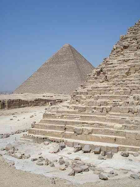 of Egypt, the only surviving Wonder of the ancient Seven, received an honorary status among the New Seven Wonders. Its inclusion enabled a Wonder to be listed for five of the six habitable continents (all but Australia).
While all of the above Wonders are indeed outstanding, their presence in any type of list is entirely subjective. There are many other fabulous sites around the world that are equally worthy of being designated as Wonders. (An example is the inclusion of Chichen Itza from Mexico. While it is spectacular, it became a 'Wonder' for its popularity as a tourist site. Equally worthy in the same country is Teotihuacan, a far larger site outside of Mexico City that has two immense pyramids that dwarf the one at Chichen Itza.)
Taking these considerations into account, The World Factbook has come up with a Seven Wonders list that is indisputable, i.e., a list derived in a completely objective manner. A decision was made to focus on natural wonders and not anything man-made. These Wonders are all the biggest in their respective categories (they cannot be topped) and so there can be no dispute with the choice, therefore the 'ultra' designation. This fact distinguishes the Factbook listing from other Seven Natural Wonders lists that have been compiled in the past.
1. 
A trans-national Wonder that is: a. the World's largest collection of land biodiversity, b. the World's largest rainforest, and c. includes the World's largest swamp in the Amazon River floodplain; mostly in Brazil, Peru, and Colombia, but also in Venezuela, Ecuador, Bolivia, Guyana, Suriname, and French Guiana.
2. 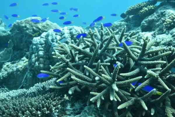
A Wonder hotspot that is the World's largest collection of marine biodiversity; best represented by the Coral Triangle in the tropical waters around the Philippines, Indonesia, Malaysia, Papua New Guinea, the Solomon Islands, and Timor-Leste; as well as by the Great Barrier Reef (the World's largest reef) in Australia.
3. 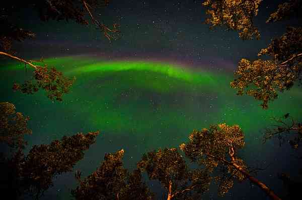 (Aurora Borealis and Aurora Australis; aka the Polar Lights)
The World's largest light display that never ceases to awe; seen in countries of the northern latitudes, as well as those of the southern latitudes and Antarctica.
4. 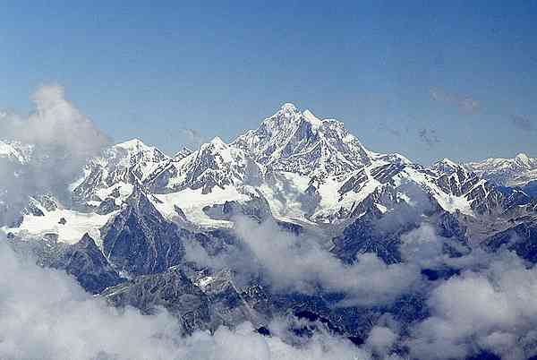
The World's tallest mountain and mountain range above sea level that stretches across Nepal, China (Tibet), India, Pakistan, and Bhutan (see alternate below).
5. 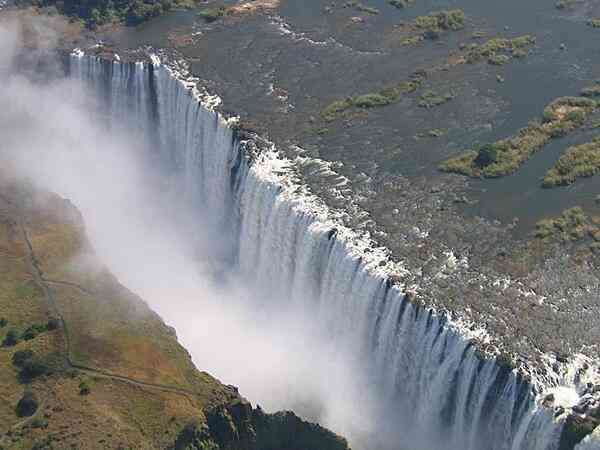
The World's largest unbroken waterfall on the border between Zambia and Zimbabwe (see alternates below).
6. 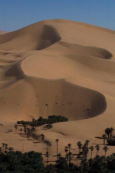
The World's largest hot desert that spreads across Algeria, Chad, Egypt, Libya, Mali, Mauritania, Morocco, Niger, Sudan, and Tunisia (see alternate below).
7. 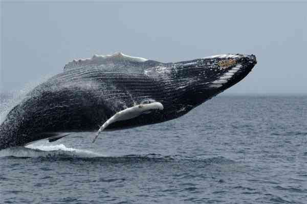
The Earth is full of astounding migrations – occurring daily, seasonally, or annually – that are truly awe-inspiring natural wonders. A few extraordinary examples are: a. the diel vertical migrations (DVM, the World's largest animal migration in terms of biomass and number of animals participating), which occur twice daily in all the oceans when zooplankton (microscopic animals) and fish rise to near the surface at night to feed on phytoplankton (microscopic plants) and then with the return of day dive back into the depths to hide in dark waters; b. the Arctic tern's annual round trip of 71,000 km (from the Northern Hemisphere to the Southern Hemisphere and back (the World's longest avian migration); or c. the 22,000 km annual migration of the humpback whale (World's longest mammal migration).
Alternates
Mountain alternate (no. 4). If measured strictly from base to peak, then the World's tallest and largest mountains would be on the Island of Hawaii, which includes both the World's tallest mountain [Mauna Kea] and the World's largest active volcano and most voluminous mountain [Mauna Loa]); United States (Hawaii).
Waterfall alternate (no. 5). What constitutes the 'biggest' waterfall(s) can be approached in a number of ways. Depending on one's viewpoint, Iguazu Falls (World's largest waterfall system (275 drops)) in Argentina and Brazil, or Angel Falls (World's tallest waterfall) in Venezuela could substitute.
Desert alternate (no. 6). If a desert is defined as a barren area where little precipitation occurs, then Antarctica with the World's largest polar desert would certainly qualify; it is about 1.5 times the size of the Sahara. The southern continent does not belong to any one country but is a condominium governed by parties to the Antarctic Treaty.
note: A question might arise, how about the World's largest canyon? The Grand Canyon (United States, Arizona) is sometimes mentioned as a Wonder of the World, but 'largest' canyons can be notoriously difficult to define and measure. Does one go by length, depth, or total area of canyon system? Then too, there are largely inaccessible canyons in the Himalayas that have never been properly surveyed and massive canyons are known to exist in some ice-covered parts of Greenland and Antarctica. Therefore, it is not possible to come up with a superlative canyon.
note 1: the World is now thought to be about 4.55 billion years old, just about one-third of the 13.8-billion-year age estimated for the universe; the earliest widely accepted date for life appearing on Earth is 3.48 billion years ago, but this date is conservative and may get pushed back further
note 2: although earthquakes can strike anywhere at any time, the vast majority occur in three large zones of the Earth; the world's greatest earthquake belt, the Circum-Pacific Belt (popularly referred to as the Ring of Fire), is the zone of active volcanoes and earthquake epicenters bordering the Pacific Ocean; about 90% of the World's earthquakes (81% of the largest earthquakes) and some 75% of the World's volcanoes occur within the Ring of Fire; the belt extends northward from Chile, along the South American coast, through Central America, Mexico, the western US, southern Alaska and the Aleutian Islands, to Japan, the Philippines, Papua New Guinea, island groups in the southwestern Pacific, and New Zealand
the second prominent belt, the Alpide, extends from Java to Sumatra, northward along the mountains of Burma, then eastward through the Himalayas, the Mediterranean, and out into the Atlantic Ocean; it accounts for about 17% of the world's largest earthquakes; the third important belt follows the long Mid-Atlantic Ridge
note 3: information on the origin sites for many of the World's major food crops may be found in the "Geography - note" for the following countries: Argentina, Bolivia, Brazil, China, Ecuador, Ethiopia, Indonesia, Mexico, Papua New Guinea, Paraguay, Peru, and the United States
NOTE: The information regarding World on this page is re-published from the 2024 World Fact Book of the United States Central Intelligence Agency and other sources. No claims are made regarding the accuracy of World 2024 information contained here. All suggestions for corrections of any errors about World 2024 should be addressed to the CIA or the source cited on each page.


This page was last modified 04 May 24, Copyright © 2024 ITA all rights reserved.


