


Location:
Southern Europe, islands in the Mediterranean Sea, south of Sicily (Italy)
Geographic coordinates:
35 50 N, 14 35 E
Map references:
Europe
Area:
total: 316 sq km
[see also: Area - total country ranks ]
land: 316 sq km
[see also: Area - land country ranks ]
water: 0 sq km
[see also: Area - water country ranks ]
country comparison to the world (CIA rank, may be based on non-current data):
209
Area - comparative:
slightly less than twice the size of Washington, DC
Area comparison map:
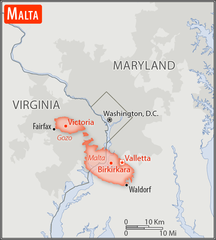
slightly less than twice the size of Washington, DC
Land boundaries:
0 km
Coastline:
196.8 km
(excludes 56 km for the island of Gozo)
[see also: Coastline country ranks ]
Maritime claims:
territorial sea: 12
nm
[see also: Maritime claims - territorial sea country ranks ]
contiguous zone: 24
nm
[see also: Maritime claims - contiguous zone country ranks ]
continental shelf:
200-m depth or to the depth of exploitation
[see also: Maritime claims - continental shelf country ranks ]
exclusive fishing zone: 25
nm
[see also: Maritime claims - exclusive fishing zone country ranks ]
Climate:
Mediterranean; mild, rainy winters; hot, dry summers
More Climate Details
Terrain:
mostly low, rocky, flat to dissected plains; many coastal cliffs
Elevation:
lowest point:
Mediterranean Sea 0 m
highest point:
Ta'Dmejrek on Dingli Cliffs 253 m
Natural resources:
limestone, salt, arable land
Land use:
agricultural land: 32.3%
(2011 est.)
[see also: Land use - agricultural land country ranks ]
arable land: 28.4%
(2011 est.)
[see also: Land use - arable land country ranks ]
permanent crops: 3.9%
(2011 est.)
[see also: Land use - permanent crops country ranks ]
permanent pasture: 0%
(2011 est.)
[see also: Land use - permanent pasture country ranks ]
forest: 0.9%
(2011 est.)
[see also: Land use - forest country ranks ]
other: 66.8%
(2011 est.)
[see also: Land use country ranks ]
Irrigated land:
35 sq km
(2012)
[see also: Irrigated land country ranks ]
Population distribution:
most of the population lives on the eastern half of Malta, the largest of the three inhabited islands
Natural hazards:
occasional droughts
Environment - current issues:
limited natural freshwater resources; increasing reliance on desalination; deforestation; wildlife preservation
Environment - international agreements:
party to:
Air Pollution, Biodiversity, Climate Change, Climate Change-Kyoto Protocol, Desertification, Endangered Species, Hazardous Wastes, Law of the Sea, Marine Dumping, Ozone Layer Protection, Ship Pollution, Wetlands
signed, but not ratified:
none of the selected agreements
Geography - note:
the country comprises an archipelago, with only the three largest islands (Malta, Ghawdex or Gozo, and Kemmuna or Comino) inhabited; numerous bays provide good harbors; Malta and Tunisia are discussing oil exploration on the continental shelf between their countries, although no commercially viable reserves have been found as of 2017
NOTE: 1) The information regarding Malta on this page is re-published from the 2020 World Fact Book of the United States Central Intelligence Agency and other sources. No claims are made regarding the accuracy of Malta Geography 2020 information contained here. All suggestions for corrections of any errors about Malta Geography 2020 should be addressed to the CIA or the source cited on each page.
2) The rank that you see is the CIA reported rank, which may have the following issues:
a) They assign increasing rank number, alphabetically for countries with the same value of the ranked item, whereas we assign them the same rank.
b) The CIA sometimes assigns counterintuitive ranks. For example, it assigns unemployment rates in increasing order, whereas we rank them in decreasing order.
- Main Index
- 2020 Index
- Country Ranks
- Definitions
- Malta Index 2020
- Malta Main Index
- Introduction
- History
- Geography
- Climate
- Maps
- People
- Religion
- Government
- Gov. Leaders
- Flags
- Economy
- Energy
- Communications
- Transportation
- Airport Codes
- Military
- Transnational Issues
- Photos
- Advertise Here
- Feedback

This page was last modified 27-Jan-20