


Location:
Oceania, islands in the South Pacific Ocean, southeast of Australia
Geographic coordinates:
41 00 S, 174 00 E
Map references:
Oceania
Area:
total: 268,838 sq km
[see also: Area - total country ranks ]
land: 264,537 sq km
[see also: Area - land country ranks ]
water: 4,301 sq km
note: includes Antipodes Islands, Auckland Islands, Bounty Islands, Campbell Island, Chatham Islands, and Kermadec Islands
country comparison to the world (CIA rank, may be based on non-current data):
77
Area - comparative:
almost twice the size of North Carolina; about the size of Colorado
Area comparison map:
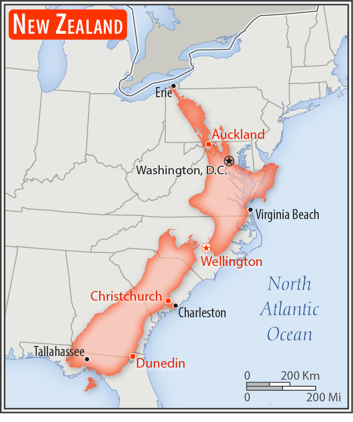
almost twice the size of North Carolina; about the size of Colorado
Land boundaries:
0 km
Coastline:
15,134 km
[see also: Coastline country ranks ]
Maritime claims:
territorial sea: 12
nm
[see also: Maritime claims - territorial sea country ranks ]
exclusive economic zone: 200
nm
[see also: Maritime claims - exclusive economic zone country ranks ]
contiguous zone: 24
nm
[see also: Maritime claims - contiguous zone country ranks ]
continental shelf: 200
nm or to the edge of the continental margin
[see also: Maritime claims - continental shelf country ranks ]
Climate:
temperate with sharp regional contrasts
More Climate Details
Terrain:
predominately mountainous with large coastal plains
Elevation:
mean elevation: 388 m
[see also: Elevation - mean elevation country ranks ]
lowest point:
Pacific Ocean 0 m
highest point:
Aoraki/Mount Cook 3,724 m; note - the mountain's height was 3,764 m until 14 December 1991 when it lost about 10 m in an avalanche of rock and ice; erosion of the ice cap since then has brought the height down another 30 m
Natural resources:
natural gas, iron ore, sand, coal, timber, hydropower, gold, limestone
Land use:
agricultural land: 43.2%
(2011 est.)
[see also: Land use - agricultural land country ranks ]
arable land: 1.8%
(2011 est.)
[see also: Land use - arable land country ranks ]
permanent crops: 0.3%
(2011 est.)
[see also: Land use - permanent crops country ranks ]
permanent pasture: 41.1%
(2011 est.)
[see also: Land use - permanent pasture country ranks ]
forest: 31.4%
(2011 est.)
[see also: Land use - forest country ranks ]
other: 25.4%
(2011 est.)
[see also: Land use country ranks ]
Irrigated land:
7,210 sq km
(2012)
[see also: Irrigated land country ranks ]
Population distribution:
over three-quarters of New Zealanders, including the indigenous Maori, live on the North Island, primarily in urban areas
Natural hazards:
earthquakes are common, though usually not severe; volcanic activity
volcanism: significant volcanism on North Island; Ruapehu (2,797 m), which last erupted in 2007, has a history of large eruptions in the past century; Taranaki has the potential to produce dangerous avalanches and lahars; other historically active volcanoes include Okataina, Raoul Island, Tongariro, and White Island; see note 2 under "Geography - note"
Environment - current issues:
water quality and availability; rapid urbanisation; deforestation; soil erosion and degradation; native flora and fauna hard-hit by invasive species; negative effects of climate change
Environment - international agreements:
party to:
Antarctic-Environmental Protocol, Antarctic-Marine Living Resources, Antarctic Treaty, Biodiversity, Climate Change, Climate Change-Kyoto Protocol, Desertification, Endangered Species, Environmental Modification, Hazardous Wastes, Law of the Sea, Marine Dumping, Ozone Layer Protection, Ship Pollution, Tropical Timber 83, Tropical Timber 94, Wetlands, Whaling
signed, but not ratified:
Antarctic Seals, Marine Life Conservation
note 1: consists of two main islands and a number of smaller islands; South Island, the larger main island, is the 12th largest island in the world and is divided along its length by the Southern Alps; North Island is the 14th largest island in the world and is not as mountainous, but it is marked by volcanism
note 2: New Zealand lies along the Ring of Fire, a belt of active volcanoes and earthquake epicenters bordering the Pacific Ocean; up to 90% of the world's earthquakes and some 75% of the world's volcanoes occur within the Ring of Fire
note 3: almost 90% of the population lives in cities and over three-quarters on North Island; Wellington is the southernmost national capital in the world
NOTE: 1) The information regarding New Zealand on this page is re-published from the 2020 World Fact Book of the United States Central Intelligence Agency and other sources. No claims are made regarding the accuracy of New Zealand Geography 2020 information contained here. All suggestions for corrections of any errors about New Zealand Geography 2020 should be addressed to the CIA or the source cited on each page.
2) The rank that you see is the CIA reported rank, which may have the following issues:
a) They assign increasing rank number, alphabetically for countries with the same value of the ranked item, whereas we assign them the same rank.
b) The CIA sometimes assigns counterintuitive ranks. For example, it assigns unemployment rates in increasing order, whereas we rank them in decreasing order.
- Main Index
- 2020 Index
- Country Ranks
- Definitions
- New Zealand Index 2020
- New Zealand Main Index
- Introduction
- History
- Geography
- Climate
- Maps
- People
- Religion
- Government
- Gov. Leaders
- Flags
- Economy
- Energy
- Communications
- Transportation
- Airport Codes
- Military
- Transnational Issues
- Photos
- Advertise Here
- Feedback

This page was last modified 27-Jan-20