


Location:
Oceania, group of islands in the North Pacific Ocean, southeast of the Philippines
Geographic coordinates:
7 30 N, 134 30 E
Map references:
Oceania
Area:
total: 459 sq km
[see also: Area - total country ranks ]
land: 459 sq km
[see also: Area - land country ranks ]
water: 0 sq km
[see also: Area - water country ranks ]
country comparison to the world (CIA rank, may be based on non-current data):
198
Area - comparative:
slightly more than 2.5 times the size of Washington, DC
Area comparison map:
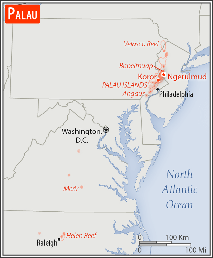
slightly more than 2.5 times the size of Washington, DC
Land boundaries:
0 km
Coastline:
1,519 km
[see also: Coastline country ranks ]
Maritime claims:
territorial sea: 12
nm
[see also: Maritime claims - territorial sea country ranks ]
exclusive economic zone: 200
nm
[see also: Maritime claims - exclusive economic zone country ranks ]
contiguous zone: 24
nm
[see also: Maritime claims - contiguous zone country ranks ]
continental shelf: 200
nm
[see also: Maritime claims - continental shelf country ranks ]
Climate:
tropical; hot and humid; wet season May to November
Terrain:
varying topography from the high, mountainous main island of Babelthuap to low, coral islands usually fringed by large barrier reefs
Elevation:
lowest point:
Pacific Ocean 0 m
highest point:
Mount Ngerchelchuus 242 m
Natural resources:
forests, minerals (especially gold), marine products, deep-seabed minerals
Land use:
agricultural land: 10.8%
(2011 est.)
[see also: Land use - agricultural land country ranks ]
arable land: 2.2%
(2011 est.)
[see also: Land use - arable land country ranks ]
permanent crops: 4.3%
(2011 est.)
[see also: Land use - permanent crops country ranks ]
permanent pasture: 4.3%
(2011 est.)
[see also: Land use - permanent pasture country ranks ]
forest: 87.6%
(2011 est.)
[see also: Land use - forest country ranks ]
other: 1.6%
(2011 est.)
[see also: Land use country ranks ]
Irrigated land:
0 sq km
(2012)
[see also: Irrigated land country ranks ]
Population distribution:
most of the population is located on the southern end of the main island of Babelthuap
Natural hazards:
typhoons (June to December)
Environment - current issues:
inadequate facilities for disposal of solid waste; threats to the marine ecosystem from sand and coral dredging, illegal and destructive fishing practices, and overfishing; climate change contributes to rising sea level and coral bleaching; drought
Environment - international agreements:
party to:
Biodiversity, Climate Change, Climate Change-Kyoto Protocol, Desertification, Hazardous Wastes, Law of the Sea, Ozone Layer Protection, Wetlands, Whaling
signed, but not ratified:
none of the selected agreements
Geography - note:
westernmost archipelago in the Caroline chain, consists of six island groups totaling more than 300 islands; includes World War II battleground of Beliliou (Peleliu) and world-famous Rock Islands
NOTE: 1) The information regarding Palau on this page is re-published from the 2020 World Fact Book of the United States Central Intelligence Agency and other sources. No claims are made regarding the accuracy of Palau Geography 2020 information contained here. All suggestions for corrections of any errors about Palau Geography 2020 should be addressed to the CIA or the source cited on each page.
2) The rank that you see is the CIA reported rank, which may have the following issues:
a) They assign increasing rank number, alphabetically for countries with the same value of the ranked item, whereas we assign them the same rank.
b) The CIA sometimes assigns counterintuitive ranks. For example, it assigns unemployment rates in increasing order, whereas we rank them in decreasing order.
- Main Index
- 2020 Index
- Country Ranks
- Definitions
- Palau Index 2020
- Palau Main Index
- Introduction
- History
- Geography
- Maps
- People
- Religion
- Government
- Gov. Leaders
- Flags
- Economy
- Energy
- Communications
- Transportation
- Airport Codes
- Military
- Transnational Issues
- Photos
- Advertise Here
- Feedback

This page was last modified 27-Jan-20