


Location:
Caribbean, islands between the Caribbean Sea and North Atlantic Ocean, north of Trinidad and Tobago
Geographic coordinates:
13 15 N, 61 12 W
Map references:
Central America and the Caribbean
Area:
total: 389 sq km
(Saint Vincent 344 sq km)
[see also: Area - total country ranks ]
land: 389 sq km
[see also: Area - land country ranks ]
water: 0 sq km
[see also: Area - water country ranks ]
country comparison to the world (CIA rank, may be based on non-current data):
205
Area - comparative:
twice the size of Washington, DC
Area comparison map:
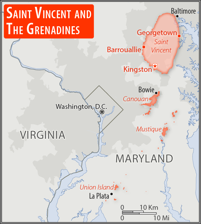
twice the size of Washington, DC
Land boundaries:
0 km
Coastline:
84 km
[see also: Coastline country ranks ]
Maritime claims:
territorial sea: 12
nm
[see also: Maritime claims - territorial sea country ranks ]
exclusive economic zone: 200
nm
[see also: Maritime claims - exclusive economic zone country ranks ]
contiguous zone: 24
nm
[see also: Maritime claims - contiguous zone country ranks ]
continental shelf: 200
nm
[see also: Maritime claims - continental shelf country ranks ]
Climate:
tropical; little seasonal temperature variation; rainy season (May to November)
Terrain:
volcanic, mountainous
Elevation:
lowest point:
Caribbean Sea 0 m
highest point:
La Soufriere 1,234 m
Natural resources:
hydropower, arable land
Land use:
agricultural land: 25.6%
(2011 est.)
[see also: Land use - agricultural land country ranks ]
arable land: 12.8%
(2011 est.)
[see also: Land use - arable land country ranks ]
permanent crops: 7.7%
(2011 est.)
[see also: Land use - permanent crops country ranks ]
permanent pasture: 5.1%
(2011 est.)
[see also: Land use - permanent pasture country ranks ]
forest: 68.7%
(2011 est.)
[see also: Land use - forest country ranks ]
other: 5.7%
(2011 est.)
[see also: Land use country ranks ]
Irrigated land:
10 sq km
(2012)
[see also: Irrigated land country ranks ]
Population distribution:
most of the population is concentrated in and around the capital of Kingstown
Natural hazards:
hurricanes; La Soufriere volcano on the island of Saint Vincent is a constant threat
volcanism: La Soufriere (1,234 m) on the island of Saint Vincent last erupted in 1979; the island of Saint Vincent is part of the volcanic island arc of the Lesser Antilles that extends from Saba in the north to Grenada in the south
Environment - current issues:
pollution of coastal waters and shorelines from discharges by pleasure yachts and other effluents; in some areas, pollution is severe enough to make swimming prohibitive; poor land use planning; deforestation; watershed management and squatter settlement control
Environment - international agreements:
party to:
Biodiversity, Climate Change, Climate Change-Kyoto Protocol, Desertification, Endangered Species, Environmental Modification, Hazardous Wastes, Law of the Sea, Marine Dumping, Ozone Layer Protection, Ship Pollution, Whaling
signed, but not ratified:
none of the selected agreements
Geography - note:
the administration of the islands of the Grenadines group is divided between Saint Vincent and the Grenadines and Grenada; Saint Vincent and the Grenadines is comprised of 32 islands and cays
NOTE: 1) The information regarding Saint Vincent and the Grenadines on this page is re-published from the 2020 World Fact Book of the United States Central Intelligence Agency and other sources. No claims are made regarding the accuracy of Saint Vincent and the Grenadines Geography 2020 information contained here. All suggestions for corrections of any errors about Saint Vincent and the Grenadines Geography 2020 should be addressed to the CIA or the source cited on each page.
2) The rank that you see is the CIA reported rank, which may have the following issues:
a) They assign increasing rank number, alphabetically for countries with the same value of the ranked item, whereas we assign them the same rank.
b) The CIA sometimes assigns counterintuitive ranks. For example, it assigns unemployment rates in increasing order, whereas we rank them in decreasing order.
- Main Index
- 2020 Index
- Country Ranks
- Definitions
- Saint Vincent and the Grenadines Index 2020
- Saint Vincent and the Grenadines Main Index
- Introduction
- History
- Geography
- Maps
- People
- Religion
- Government
- Gov. Leaders
- Flags
- Economy
- Energy
- Communications
- Transportation
- Airport Codes
- Military
- Transnational Issues
- Photos
- Advertise Here
- Feedback

This page was last modified 27-Jan-20