Central Africa, bordering the Atlantic Ocean at the Equator, between Republic of the Congo and Equatorial Guinea
1 00 S, 11 45 E
Africa
total: 267,667 sq km
land: 257,667 sq km
water: 10,000 sq km
slightly smaller than Colorado
total: 3,261 km
border countries (3): Cameroon 349 km; Republic of the Congo 2,567 km; Equatorial Guinea 345 km
885 km
territorial sea: 12 nm
contiguous zone: 24 nm
exclusive economic zone: 200 nm
tropical; always hot, humid
narrow coastal plain; hilly interior; savanna in east and south
highest point: Mont Bengoue 1,050 m
lowest point: Atlantic Ocean 0 m
mean elevation: 377 m
petroleum, natural gas, diamond, niobium, manganese, uranium, gold, timber, iron ore, hydropower
agricultural land: 19% (2018 est.)
arable land: 1.2% (2018 est.)
permanent crops: 0.6% (2018 est.)
permanent pasture: 17.2% (2018 est.)
forest: 81% (2018 est.)
other: 0% (2018 est.)
40 sq km (2012)
Atlantic Ocean drainage: Congo (3,730,881 sq km)
Congo Basin
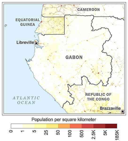
the relatively small population is spread in pockets throughout the country; the largest urban center is the capital of Libreville, located along the Atlantic coast in the northwest as shown in this 
none
a small population and oil and mineral reserves have helped Gabon become one of Africa's wealthier countries; in general, these circumstances have allowed the country to maintain and conserve its pristine rain forest and rich biodiversity
NOTE: The information regarding Gabon on this page is re-published from the 2024 World Fact Book of the United States Central Intelligence Agency and other sources. No claims are made regarding the accuracy of Gabon 2024 information contained here. All suggestions for corrections of any errors about Gabon 2024 should be addressed to the CIA or the source cited on each page.
This page was last modified 04 May 24, Copyright © 2024 ITA all rights reserved.