
large areas subject to overpopulation, industrial disasters, pollution (air, water, acid rain, toxic substances), loss of vegetation (overgrazing, deforestation, desertification), loss of biodiversity; soil degradation, soil depletion, erosion; ozone layer depletion; waste disposal; global warming becoming a greater concern
Types of Biomes:
A biome is a biogeographical designation describing a biological community of plants and animals that has formed in response to a physical environment and a shared regional climate. Biomes can extend over more than one continent. Different classification systems define different numbers of biomes. The World Factbook recognizes the following seven biomes used by NASA: Tundra, Coniferous Forest, Temperate Deciduous Forest, Rainforest, Grassland, Shrubland, and Desert.
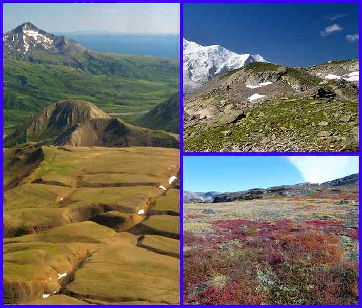
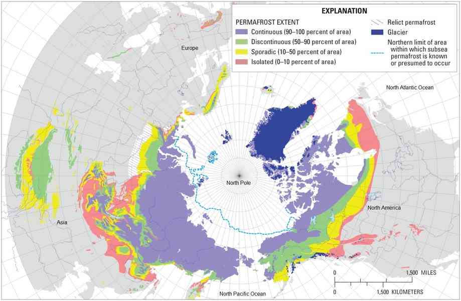
The tundra is the coldest of the biomes. It also receives low amounts of precipitation, making the tundra similar to a desert. Tundra comes from the Finnish word tunturia, meaning "treeless plain". Tundra is found in the regions just below the ice caps of the Arctic, extending across North America, to Europe, and Siberia in Asia. Temperatures usually range between -40°C (-40 °F) and 18°C (64°F). The temperatures are so cold that there is a layer of permanently frozen ground below the surface, called permafrost. This permafrost is a defining characteristic of the tundra biome. In the tundra summers, the top layer of soil thaws only a few inches down, providing a growing surface for the roots of vegetation. This biome sees 150 to 250 mm (6 to 10 in) of rain per year. Vegetation in the tundra has adapted to the cold and the short growing season and consists of lichens, mosses, grasses, sedges, shrubs, but almost no trees due to short growing season and permafrost.
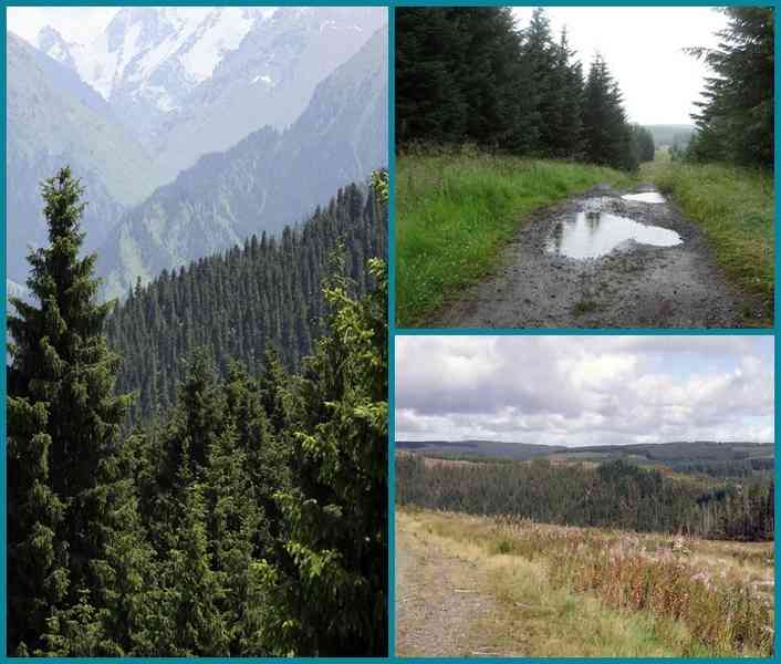
Coniferous Forest biome: The coniferous forest is sandwiched in between the tundra to the north and the deciduous forest to the south. Coniferous forest regions have cold, long, snowy winters, and warm, humid summers; well-defined seasons; and at least four to six frost-free months. The average temperature in winter ranges from -40°C (-40°F) to 20°C (68°F). The average summer temperatures are usually around 10°C (50°F). 300 to 900 mm (12 to 35 in) of rain per year can be expected in this biome. Vegetation consists of trees that produce cones and needles called, coniferous-evergreen trees. Some needles remain on the trees all year long. Some of the more common conifers are spruces, pines, and firs.
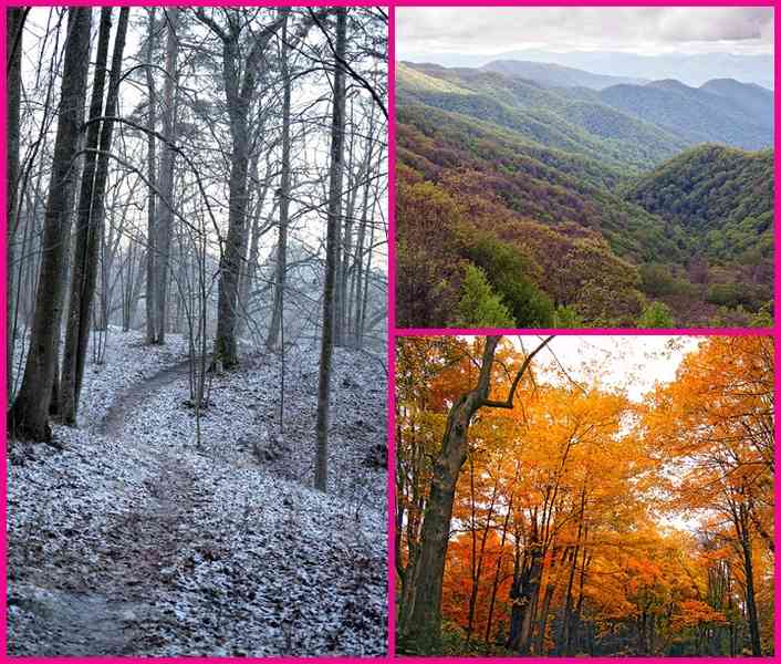
Temperate Deciduous Forest biome: Temperate deciduous forests are located in the mid-latitude areas which means that they are found between the polar regions and the tropics. The deciduous forest regions are exposed to warm and cold air masses, which cause this area to have four seasons. Hot summers and cold winters are typical in this biome. The average daily temperatures range between -30°C (-22°F) and 30°C (86°F) with a yearly average of 10°C (50°F). On average, this biome receives 750 to 1,500 mm (30 to 59 in) of rain per year. Vegetation includes broadleaf trees (oaks, maples, beeches), shrubs, perennial herbs, and mosses. Temperate deciduous forests are most notable for their transitioning through four seasons. Leaves change color (or senesce) in autumn, fall off in the winter, and grow back in the spring; this adaptation allows plants to survive cold winters.
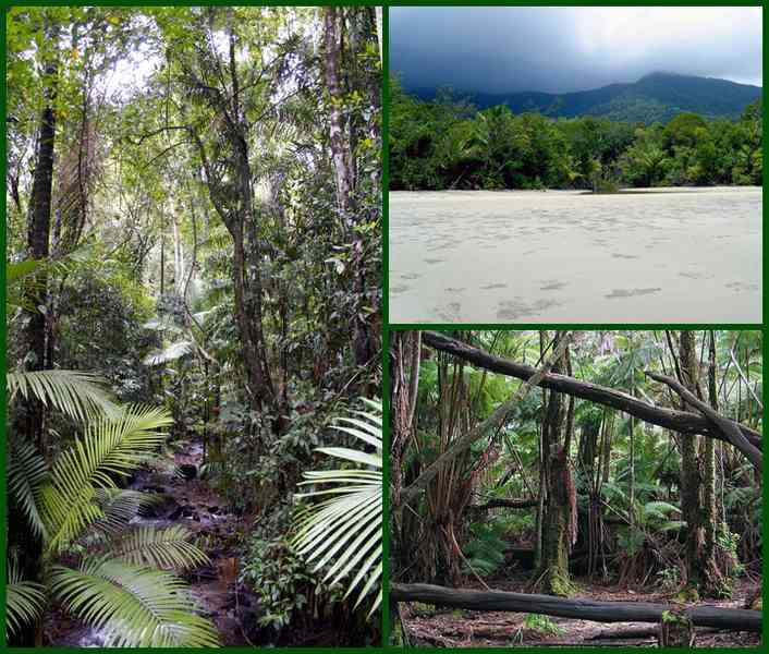
Rainforest biome: The rainforest biome remains warm all year and must stay frost-free. The average daily temperatures range from 20°C (68°F) to 25°C (77°F). Rainforests receive the most rain of all of the biomes in a year! A typical year sees 2,000 to 10,000 mm (79 to 394 in) of rain per year. Vegetation typically includes vines, palm trees, orchids, ferns. There are two types of rainforests, tropical and temperate. Tropical rainforests are found closer to the equator and temperate rainforests are found farther north near coastal areas. The majority of common houseplants come from the rainforest.
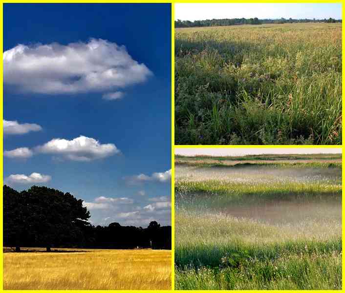
Grassland biome: Grasslands are generally open and continuous, fairly flat areas of grass. They are often located between temperate forests at high latitudes and deserts at subtropical latitudes. Found on every continent except Antarctica. Depending on latitude, the annual temperature range can be between -20°C (-4°F) to 30°C (86°F). Grasslands receive around 500 to 900 mm (20 to 35 in) of rain per year. Tropical grasslands have dry and wet seasons that remain warm all the time. Temperate grasslands have cold winters and warm summers with some rain. Vegetation is dominated by grasses but can include sedges and rushes along with some legumes (clover) and herbs. The grasses die back to their roots annually and the soil and the sod protect the roots and the new buds from the cold of winter or dry conditions. A few trees may be found in this biome along the streams, but not many due to the lack of rainfall.
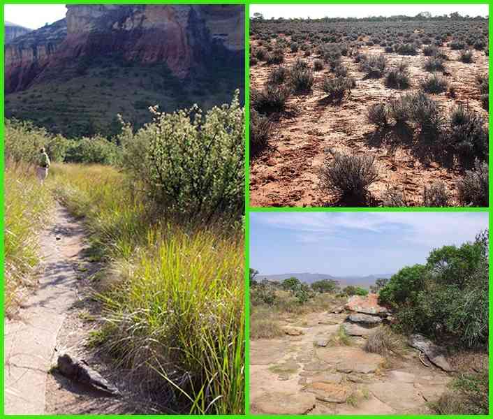
Shrubland biome: Shrublands include regions such as chaparral, woodland and savanna, and are composed of shrubs or short trees. Many shrubs thrive on steep, rocky slopes, but there is usually not enough rain to support tall trees. Shrublands are the areas that are located in west coastal regions between 30° and 40° North and South latitude. These regions are usually found surrounding deserts and grasslands. The summers are hot and dry with temperatures reaching up to 38°C (100°F). In the winter, temperatures stay around -1 °C (30°F) and are cool and moist. Annual rainfall in the shrublands varies greatly but generally 200 to 1,000 mm (8 to 40 in) of rain per year can be expected. Vegetation comprises aromatic herbs (sage, rosemary, thyme, oregano), shrubs, acacia, chamise, grasses. Plants have adapted to fire caused by the frequent lightning that occurs in the hot, dry summers.
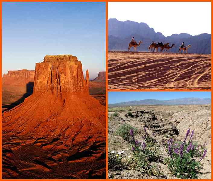
Desert biome: Desert biomes are the driest of all the biomes. In fact, the most important characteristic of a desert is that it receives very little rainfall. Deserts get about 250 mm (10 in) of rain per year - the least amount of rain of all of the biomes. During the day, desert temperatures rise to an average of 38°C (100°F). At night, desert temperatures fall to an average of -4°C (about 25°F). Vegetation is sparse consisting of cacti, small bushes, short grasses. Perennials survive for several years by becoming dormant and flourishing when water is available. Annuals are referred to as ephemerals because some can complete an entire life cycle in weeks. Since desert conditions are so severe, the plants that live there need to have adaptations to compensate for the lack of water. Some plants, such as cacti, store water in their stems and use it very slowly, while others like bushes conserve water by growing few leaves or by having large root systems to gather water.
World Biomes: 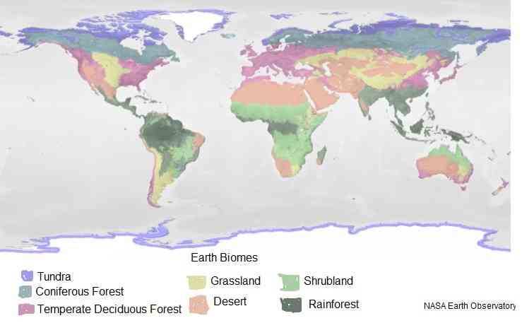 Tundra biome:
  Circum-polar Extent of Permafrost:
  Coniferous Forest biome:
  Temperate Deciduous Forest biome:
  Rainforest biome:
  Grassland biome:
  Shrubland biome:
  Desert biome:
a wide equatorial band of hot and humid tropical climates, bordered north and south by subtropical temperate zones that separate two large areas of cold and dry polar climates
ten driest places on Earth (average annual precipitation): McMurdo Dry Valleys, Antarctica 0 mm (0 in)
Arica, Chile 0.76 mm (0.03 in)
Al Kufrah, Libya 0.86 mm (0.03 in)
Aswan, Egypt 0.86 mm (0.03 in)
Luxor, Egypt 0.86 mm (0.03 in)
Ica, Peru 2.29 mm (0.09 in)
Wadi Halfa, Sudan 2.45 mm (0.1 in)
Iquique, Chile 5.08 mm (0.2 in)
Pelican Point, Namibia 8.13 mm (0.32 in)
El Arab (Aoulef), Algeria 12.19 mm (0.48 in)
ten wettest places on Earth (average annual precipitation): Mawsynram, India 11,871 mm (467.4 in)
Cherrapunji, India 11,777 mm (463.7 in)
Tutunendo, Colombia 11,770 mm (463.4 in)
Cropp River, New Zealand 11,516 mm (453.4 in)
San Antonia de Ureca, Equatorial Guinea 10,450 mm (411.4 in)
Debundsha, Cameroon 10,299 mm (405.5 in)
Big Bog, US (Hawaii) 10,272 mm (404.4 in)
Mt Waialeale, US (Hawaii) 9,763 mm (384.4 in)
Kukui, US (Hawaii) 9,293 mm (365.9 in)
Emeishan, China 8,169 mm (321.6 in)
ten coldest places on Earth (lowest average monthly temperature): Verkhoyansk, Russia (Siberia) -47°C (-53°F) January
Oymyakon, Russia (Siberia) -46°C (-52°F) January
Eureka, Canada -38.4°C (-37.1°F) February
Isachsen, Canada -36°C (-32.8°F) February
Alert, Canada -34°C (-28°F) February
Kap Morris Jesup, Greenland -34°C (-29°F) March
Cornwallis Island, Canada -33.5°C (-28.3°F) February
Cambridge Bay, Canada -33.5°C (28.3°F) February
Ilirnej, Russia -33°C (-28°F) January
Resolute, Canada -33°C (-27.4°F) February
ten hottest places on Earth (highest average monthly temperature): Death Valley, US (California) 39°C (101°F) July
Iranshahr, Iran 38.3°C (100.9°F) June
Ouallene, Algeria 38°C (100.4°F) July
Kuwait City, Kuwait 37.7°C (100°F) July
Medina, Saudi Arabia 36°C (97°F) July
Buckeye, US (Arizona) 34°C (93°F) July
Jazan, Saudi Arabia 33°C (91°F) June
Al Kufrah, Libya 31°C (87°F) July
Alice Springs, Australia 29°C (84°F) January
Tamanrasset, Algeria 29°C (84°F) June
urban population: 57.5% of total population (2023)
rate of urbanization: 1.73% annual rate of change (2020-25 est.)
top ten largest natural lakes: Caspian Sea (Azerbaijan, Iran, Kazakhstan, Russia, Turkmenistan) 374,000 sq km; Lake Superior (Canada, United States) 82,100 sq km; Lake Victoria (Kenya, Tanzania, Uganda) 62,940 sq km; Lake Huron (Canada, United States) 59,600 sq km; Lake Michigan (United States) 57,750 sq km; Lake Tanganyika (Burundi, Democratic Republic of the Congo, Tanzania, Zambia) 32,000 sq km; Great Bear Lake (Canada) 31,328 sq km; Lake Baikal (Russia) 31,500 sq km; Lake Malawi (Malawi, Mozambique, Tanzania) 22,490 sq km; Great Slave Lake (Canada) 28,568 sq km
note 1: the areas of the lakes are subject to seasonal variation; only the Caspian Sea is saline, the rest are fresh water
note 2: Lakes Huron and Michigan are technically a single lake because the flow of water between the Straits of Mackinac that connects the two lakes keeps their water levels at near-equilibrium; combined, Lake Huron-Michigan is the largest freshwater lake by surface area in the World
note 3: if ranked by water volume, the Caspian Sea would still be first, but it would be followed Lakes Baikal, Tanganyika, Superior, and Malawi; Lake Superior contains more water than the other four North American Great Lakes (Erie, Huron, Michigan, Ontario) combined
top ten longest rivers: Nile (Africa) 6,650 km; Amazon (South America) 6,436 km; Yangtze (Asia) 6,300 km; Mississippi-Missouri (North America) 6,275 km; Yenisey-Angara (Asia) 5,539 km; Huang He/Yellow (Asia) 5,464 km; Ob-Irtysh (Asia) 5,410 km; Congo (Africa) 4,700 km; Amur (Asia) 4,444 km; Lena (Asia) 4,400 km
note: there are 21 countries without rivers: 3 in Africa (Comoros, Djibouti, Libya), 1 in the Americas (Bahamas), 8 in Asia (Bahrain, Kuwait, Maldives, Oman, Qatar, Saudi Arabia, United Arab Emirates, Yemen), 3 in Europe (Malta, Monaco, Holy See), 6 in Oceania (Kiribati, Marshall Islands, Nauru, Niue, Tonga, Tuvalu); these countries also do not have natural lakes
summary statement: a watershed is a drainage basin on an area of land where precipitation collects and drains off into a common outlet, such as into a river, bay, or other body of water; oceans ultimately take in the drainage from 83% of all land area; the remaining 17% of the land drains into internal (endorheic) basins, e.g., the Caspian Sea; The World Factbook lists 51 different watersheds across 102 countries; of these, 18 are in Asia, 9 in Europe, 9 in Africa, 8 in North and Central America, 5 in South America, and 2 in Australia; all watersheds with an area of at least 500,000 sq km have been included along with a number of smaller, regionally significant watersheds; together, these watersheds represent the surface hydrology water flows that are the World's primary sources of fresh water for individual consumption, industry, and agriculture
summary statement: aquifers are underground layers of water-bearing permeable rock formations; they include alluvial formations such as unconsolidated sand and gravel aquifers, sedimentary rock formations of sandstone and karst (carbonate rocks such as limestone) aquifers, as well as volcanic aquifers, and basement aquifers (igneous and metamorphic rocks that underlie sedimentary and volcanic rock sequences); groundwater from aquifers can be extracted using a water well; The World Factbook lists 37 major aquifers across 52 countries; of these, 13 are in Africa, 10 in Asia, 5 in North America, 3 in South America, 4 in Europe, and 2 in Australia; although aquifers can vary in size, the major aquifers listed in The Factbook contain the bulk of the stored volume of groundwater; the fresh water held in these aquifers represents more than 30% of the World's fresh water; in the US, groundwater is primarily used for irrigation and globally, 70% of groundwater withdrawn is used for agriculture; groundwater also supplies almost half of all drinking water worldwide
54 trillion cubic meters (2011 est.)
NOTE: The information regarding World on this page is re-published from the 2024 World Fact Book of the United States Central Intelligence Agency and other sources. No claims are made regarding the accuracy of World 2024 information contained here. All suggestions for corrections of any errors about World 2024 should be addressed to the CIA or the source cited on each page.
This page was last modified 04 May 24, Copyright © 2024 ITA all rights reserved.