
Northern Africa, bordering the Mediterranean Sea, between Morocco and Tunisia
28 00 N, 3 00 E
Africa
total: 2,381,740 sq km
land: 2,381,740 sq km
water: 0 sq km
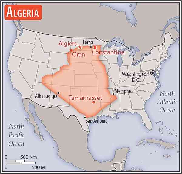
slightly less than 3.5 times the size of Texas
Area comparison map:
total: 6,734 km
border countries (6): Libya 989 km; Mali 1,359 km; Mauritania 460 km; Morocco 1,941 km; Niger 951 km; Tunisia 1,034 km
998 km
territorial sea: 12 nm
contiguous zone: 24 nm
exclusive fishing zone: 32-52 nm
arid to semiarid; mild, wet winters with hot, dry summers along coast; drier with cold winters and hot summers on high plateau; sirocco is a hot, dust/sand-laden wind especially common in summer
mostly high plateau and desert; Atlas Mountains in the far north and Hoggar Mountains in the south; narrow, discontinuous coastal plain
highest point: Tahat 2,908 m
lowest point: Chott Melrhir -40 m
mean elevation: 800 m
petroleum, natural gas, iron ore, phosphates, uranium, lead, zinc
agricultural land: 17.4% (2018 est.)
arable land: 3.2% (2018 est.)
permanent crops: 0.4% (2018 est.)
permanent pasture: 13.8% (2018 est.)
forest: 0.8% (2018 est.)
other: 81.8% (2018 est.)
12,605 sq km (2016)
Atlantic Ocean drainage: Niger (2,261,741 sq km)
Internal (endorheic basin) drainage: Lake Chad (2,497,738 sq km)
Lullemeden-Irhazer Aquifer System, Murzuk-Djado Basin, North Western Sahara Aquifer, Taoudeni-Tanezrouft Basin
the vast majority of the populace is found in the extreme northern part of the country along the Mediterranean Coast as shown in this 
mountainous areas subject to severe earthquakes; mudslides and floods in rainy season; droughts
largest country in Africa but 80% desert; canyons and caves in the southern Hoggar Mountains and in the barren Tassili n'Ajjer area in the southeast of the country contain numerous examples of prehistoric art - rock paintings and carvings depicting human activities and wild and domestic animals (elephants, giraffes, cattle) - that date to the African Humid Period, roughly 11,000 to 5,000 years ago, when the region was completely vegetated
NOTE: The information regarding Algeria on this page is re-published from the 2024 World Fact Book of the United States Central Intelligence Agency and other sources. No claims are made regarding the accuracy of Algeria 2024 information contained here. All suggestions for corrections of any errors about Algeria 2024 should be addressed to the CIA or the source cited on each page.


This page was last modified 04 May 24, Copyright © 2024 ITA all rights reserved.


