


Location:
Northern Africa, bordering the Mediterranean Sea, between Morocco and Tunisia
Geographic coordinates:
28 00 N, 3 00 E
Map references:
Africa
Area:
total: 2,381,740 sq km
[see also: Area - total country ranks ]
land: 2,381,740 sq km
[see also: Area - land country ranks ]
water: 0 sq km
[see also: Area - water country ranks ]
country comparison to the world (CIA rank, may be based on non-current data):
11
Area - comparative:
slightly less than 3.5 times the size of Texas
Area comparison map:
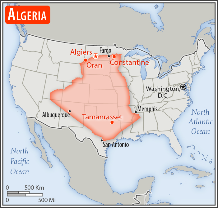
slightly less than 3.5 times the size of Texas
Land boundaries:
total: 6,734 km
[see also: Land boundaries - total country ranks ]
border countries (7):
Libya 989 km, Mali 1359 km, Mauritania 460 km, Morocco 1900 km, Niger 951 km, Tunisia 1034 km, Western Sahara 41 km
Coastline:
998 km
[see also: Coastline country ranks ]
Maritime claims:
territorial sea: 12
nm
[see also: Maritime claims - territorial sea country ranks ]
exclusive fishing zone:
32-52 nm
Climate:
arid to semiarid; mild, wet winters with hot, dry summers along coast; drier with cold winters and hot summers on high plateau; sirocco is a hot, dust/sand-laden wind especially common in summer
More Climate Details
Terrain:
mostly high plateau and desert; Atlas Mountains in the far north and Hoggar Mountains in the south; narrow, discontinuous coastal plain
Elevation:
mean elevation: 800 m
[see also: Elevation - mean elevation country ranks ]
lowest point:
Chott Melrhir -40 m
highest point:
Tahat 2,908 m
Natural resources:
petroleum, natural gas, iron ore, phosphates, uranium, lead, zinc
Land use:
agricultural land: 17.4%
(2016 est.)
[see also: Land use - agricultural land country ranks ]
arable land: 3.1%
(2016 est.)
[see also: Land use - arable land country ranks ]
permanent crops: 0.4%
(2016 est.)
[see also: Land use - permanent crops country ranks ]
permanent pasture: 13.8%
(2016 est.)
[see also: Land use - permanent pasture country ranks ]
forest: 0.8%
(2016 est.)
[see also: Land use - forest country ranks ]
other: 81.8%
(2016 est.)
[see also: Land use country ranks ]
Irrigated land:
13,600 sq km
(2014)
[see also: Irrigated land country ranks ]
Population distribution:
the vast majority of the populace is found in the extreme northern part of the country along the Mediterranean Coast
Natural hazards:
mountainous areas subject to severe earthquakes; mudslides and floods in rainy season; droughts
Environment - current issues:
air pollution in major cities; soil erosion from overgrazing and other poor farming practices; desertification; dumping of raw sewage, petroleum refining wastes, and other industrial effluents is leading to the pollution of rivers and coastal waters; Mediterranean Sea, in particular, becoming polluted from oil wastes, soil erosion, and fertilizer runoff; inadequate supplies of potable water
Environment - international agreements:
party to:
Biodiversity, Climate Change, Climate Change-Kyoto Protocol, Desertification, Endangered Species, Environmental Modification, Hazardous Wastes, Law of the Sea, Ozone Layer Protection, Ship Pollution, Wetlands
signed, but not ratified:
none of the selected agreements
Geography - note:
largest country in Africa but 80% desert; canyons and caves in the southern Hoggar Mountains and in the barren Tassili n'Ajjer area in the southeast of the country contain numerous examples of prehistoric art - rock paintings and carvings depicting human activities and wild and domestic animals (elephants, giraffes, cattle) - that date to the African Humid Period, roughly 11,000 to 5,000 years ago, when the region was completely vegetated
NOTE: 1) The information regarding Algeria on this page is re-published from the 2020 World Fact Book of the United States Central Intelligence Agency and other sources. No claims are made regarding the accuracy of Algeria Geography 2020 information contained here. All suggestions for corrections of any errors about Algeria Geography 2020 should be addressed to the CIA or the source cited on each page.
2) The rank that you see is the CIA reported rank, which may have the following issues:
a) They assign increasing rank number, alphabetically for countries with the same value of the ranked item, whereas we assign them the same rank.
b) The CIA sometimes assigns counterintuitive ranks. For example, it assigns unemployment rates in increasing order, whereas we rank them in decreasing order.
- Main Index
- 2020 Index
- Country Ranks
- Definitions
- Algeria Index 2020
- Algeria Main Index
- Introduction
- History
- Geography
- Climate
- Maps
- People
- Religion
- Government
- Gov. Leaders
- Flags
- Economy
- Energy
- Communications
- Transportation
- Airport Codes
- Military
- Terrorism
- Transnational Issues
- Photos
- Advertise Here
- Feedback

This page was last modified 27-Jan-20