


Location:
Oceania, continent between the Indian Ocean and the South Pacific Ocean
Geographic coordinates:
27 00 S, 133 00 E
Map references:
Oceania
Area:
total: 7,741,220 sq km
[see also: Area - total country ranks ]
land: 7,682,300 sq km
[see also: Area - land country ranks ]
water: 58,920 sq km
note: includes Lord Howe Island and Macquarie Island
country comparison to the world (CIA rank, may be based on non-current data):
7
Area - comparative:
slightly smaller than the US contiguous 48 states
Area comparison map:
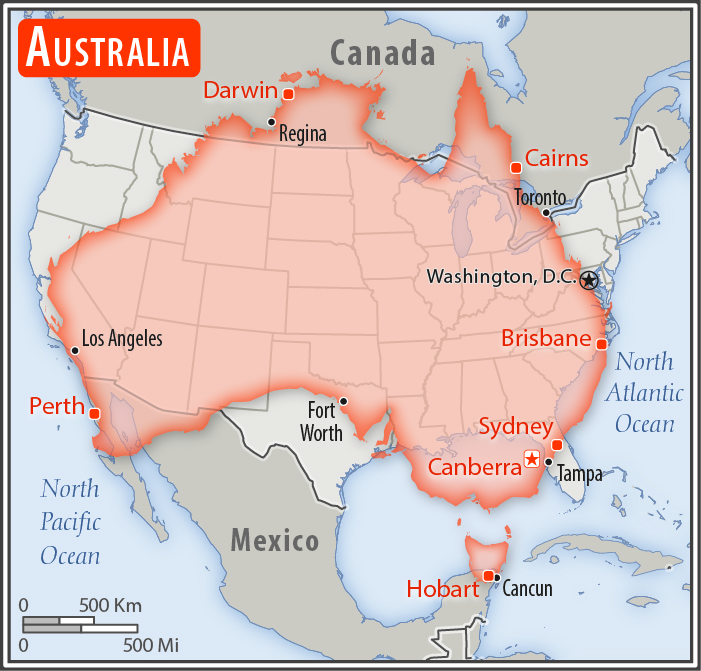
slightly smaller than the US contiguous 48 states
Land boundaries:
0 km
Coastline:
25,760 km
[see also: Coastline country ranks ]
Maritime claims:
territorial sea: 12
nm
[see also: Maritime claims - territorial sea country ranks ]
exclusive economic zone: 200
nm
[see also: Maritime claims - exclusive economic zone country ranks ]
contiguous zone: 24
nm
[see also: Maritime claims - contiguous zone country ranks ]
continental shelf: 200
nm or to the edge of the continental margin
[see also: Maritime claims - continental shelf country ranks ]
Climate:
generally arid to semiarid; temperate in south and east; tropical in north
More Climate Details
Terrain:
mostly low plateau with deserts; fertile plain in southeast
Elevation:
mean elevation: 330 m
[see also: Elevation - mean elevation country ranks ]
lowest point:
Lake Eyre -15 m
highest point:
Mount Kosciuszko 2,228 m
Natural resources:
alumina, coal, iron ore, copper, tin, gold, silver, uranium, nickel, tungsten, rare earth elements, mineral sands, lead, zinc, diamonds, natural gas, petroleum; note - Australia is the world's largest net exporter of coal accounting for 29% of global coal exports
Land use:
agricultural land: 52.9%
(2016 est.)
[see also: Land use - agricultural land country ranks ]
arable land: 11.6%
(2016 est.)
[see also: Land use - arable land country ranks ]
permanent crops: 0.09%
(2016 est.)
[see also: Land use - permanent crops country ranks ]
permanent pasture: 88.4%
(2016 est.)
[see also: Land use - permanent pasture country ranks ]
forest: 16.2%
(2016 est.)
[see also: Land use - forest country ranks ]
other: 30.9%
(2016 est.)
[see also: Land use country ranks ]
Irrigated land:
25,460 sq km
(2014)
[see also: Irrigated land country ranks ]
Population distribution:
population is primarily located on the periphery, with the highest concentration of people residing in the east and southeast; a secondary population center is located in and around Perth in the west; of the States and Territories, New South Wales has, by far, the largest population; the interior, or "outback", has a very sparse population
Natural hazards:
cyclones along the coast; severe droughts; forest fires
volcanism: volcanic activity on Heard and McDonald Islands
Environment - current issues:
soil erosion from overgrazing, deforestation, industrial development, urbanization, and poor farming practices; limited natural freshwater resources; soil salinity rising due to the use of poor quality water; drought, desertification; clearing for agricultural purposes threatens the natural habitat of many unique animal and plant species; disruption of the fragile ecosystem has resulted in significant floral extinctions; the Great Barrier Reef off the northeast coast, the largest coral reef in the world, is threatened by increased shipping and its popularity as a tourist site; overfishing, pollution, and invasive species are also problems
Environment - international agreements:
party to:
Antarctic-Environmental Protocol, Antarctic-Marine Living Resources, Antarctic Seals, Antarctic Treaty, Biodiversity, Climate Change, Climate Change-Kyoto Protocol, Desertification, Endangered Species, Environmental Modification, Hazardous Wastes, Law of the Sea, Marine Dumping, Marine Life Conservation, Ozone Layer Protection, Ship Pollution, Tropical Timber 83, Tropical Timber 94, Wetlands, Whaling
signed, but not ratified:
none of the selected agreements
Geography - note:
note 1: world's smallest continent but sixth-largest country; the largest country in Oceania, the largest country entirely in the Southern Hemisphere, and the largest country without land borders; the only continent without glaciers; the invigorating sea breeze known as the "Fremantle Doctor" affects the city of Perth on the west coast and is one of the most consistent winds in the world
note 2: the Great Dividing Range that runs along eastern Australia is that continent’s longest mountain range and the third-longest land-based range in the world; the term "Great Dividing Range" refers to the fact that the mountains form a watershed crest from which all of the rivers of eastern Australia flow – east, west, north, and south
NOTE: 1) The information regarding Australia on this page is re-published from the 2020 World Fact Book of the United States Central Intelligence Agency and other sources. No claims are made regarding the accuracy of Australia Geography 2020 information contained here. All suggestions for corrections of any errors about Australia Geography 2020 should be addressed to the CIA or the source cited on each page.
2) The rank that you see is the CIA reported rank, which may have the following issues:
a) They assign increasing rank number, alphabetically for countries with the same value of the ranked item, whereas we assign them the same rank.
b) The CIA sometimes assigns counterintuitive ranks. For example, it assigns unemployment rates in increasing order, whereas we rank them in decreasing order.
- Main Index
- 2020 Index
- Country Ranks
- Definitions
- Australia Index 2020
- Australia Main Index
- Introduction
- History
- Geography
- Climate
- Maps
- People
- Religion
- Government
- Gov. Leaders
- Flags
- Economy
- Energy
- Communications
- Transportation
- Airport Codes
- Military
- Transnational Issues
- Photos
- Advertise Here
- Feedback

This page was last modified 27-Jan-20