


Location:
Southern Asia, bordering the Bay of Bengal, between Burma and India
Geographic coordinates:
24 00 N, 90 00 E
Map references:
Asia
Area:
total: 148,460 sq km
[see also: Area - total country ranks ]
land: 130,170 sq km
[see also: Area - land country ranks ]
water: 18,290 sq km
[see also: Area - water country ranks ]
country comparison to the world (CIA rank, may be based on non-current data):
95
Area - comparative:
slightly larger than Pennsylvania and New Jersey combined; slightly smaller than Iowa
Area comparison map:
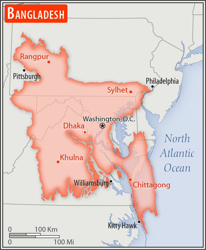
slightly larger than Pennsylvania and New Jersey combined; slightly smaller than Iowa
Land boundaries:
total: 4,413 km
[see also: Land boundaries - total country ranks ]
border countries (2):
Burma 271 km, India 4142 km
Coastline:
580 km
[see also: Coastline country ranks ]
Maritime claims:
territorial sea: 12
nm
[see also: Maritime claims - territorial sea country ranks ]
exclusive economic zone: 200
nm
[see also: Maritime claims - exclusive economic zone country ranks ]
contiguous zone: 18
nm
[see also: Maritime claims - contiguous zone country ranks ]
continental shelf:
to the outer limits of the continental margin
[see also: Maritime claims - continental shelf country ranks ]
Climate:
tropical; mild winter (October to March); hot, humid summer (March to June); humid, warm rainy monsoon (June to October)
More Climate Details
Terrain:
mostly flat alluvial plain; hilly in southeast
Elevation:
mean elevation: 85 m
[see also: Elevation - mean elevation country ranks ]
lowest point:
Indian Ocean 0 m
highest point:
Keokradong 1,230 m
Natural resources:
natural gas, arable land, timber, coal
Land use:
agricultural land: 70.1%
(2016 est.)
[see also: Land use - agricultural land country ranks ]
arable land: 59%
(2016 est.)
[see also: Land use - arable land country ranks ]
permanent crops: 6.5%
(2016 est.)
[see also: Land use - permanent crops country ranks ]
permanent pasture: 4.6%
(2016 est.)
[see also: Land use - permanent pasture country ranks ]
forest: 11.1%
(2016 est.)
[see also: Land use - forest country ranks ]
other: 18.8%
(2016 est.)
[see also: Land use country ranks ]
Irrigated land:
53,000 sq km
(2012)
[see also: Irrigated land country ranks ]
Natural hazards:
droughts; cyclones; much of the country routinely inundated during the summer monsoon season
Environment - current issues:
many people are landless and forced to live on and cultivate flood-prone land; waterborne diseases prevalent in surface water; water pollution, especially of fishing areas, results from the use of commercial pesticides; ground water contaminated by naturally occurring arsenic; intermittent water shortages because of falling water tables in the northern and central parts of the country; soil degradation and erosion; deforestation; destruction of wetlands; severe overpopulation with noise pollution
Environment - international agreements:
party to:
Biodiversity, Climate Change, Climate Change-Kyoto Protocol, Desertification, Endangered Species, Environmental Modification, Hazardous Wastes, Law of the Sea, Ozone Layer Protection, Ship Pollution, Wetlands
signed, but not ratified:
none of the selected agreements
Geography - note:
most of the country is situated on deltas of large rivers flowing from the Himalayas: the Ganges unites with the Jamuna (main channel of the Brahmaputra) and later joins the Meghna to eventually empty into the Bay of Bengal
NOTE: 1) The information regarding Bangladesh on this page is re-published from the 2020 World Fact Book of the United States Central Intelligence Agency and other sources. No claims are made regarding the accuracy of Bangladesh Geography 2020 information contained here. All suggestions for corrections of any errors about Bangladesh Geography 2020 should be addressed to the CIA or the source cited on each page.
2) The rank that you see is the CIA reported rank, which may have the following issues:
a) They assign increasing rank number, alphabetically for countries with the same value of the ranked item, whereas we assign them the same rank.
b) The CIA sometimes assigns counterintuitive ranks. For example, it assigns unemployment rates in increasing order, whereas we rank them in decreasing order.
- Main Index
- 2020 Index
- Country Ranks
- Definitions
- Bangladesh Index 2020
- Bangladesh Main Index
- Introduction
- History
- Geography
- Climate
- Maps
- People
- Religion
- Government
- Gov. Leaders
- Flags
- Economy
- Energy
- Communications
- Transportation
- Airport Codes
- Military
- Terrorism
- Transnational Issues
- Photos
- Advertise Here
- Feedback

This page was last modified 27-Jan-20