


Location:
Central Africa, bordering the Bight of Biafra, between Equatorial Guinea and Nigeria
Geographic coordinates:
6 00 N, 12 00 E
Map references:
Africa
Area:
total: 475,440 sq km
[see also: Area - total country ranks ]
land: 472,710 sq km
[see also: Area - land country ranks ]
water: 2,730 sq km
[see also: Area - water country ranks ]
country comparison to the world (CIA rank, may be based on non-current data):
55
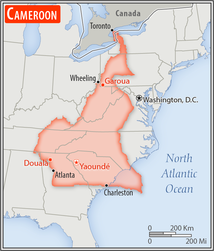
Area - comparative:
slightly larger than California; about four times the size of Pennsylvania
Area comparison map:
slightly larger than California; about four times the size of Pennsylvania
Land boundaries:
total: 5,018 km
[see also: Land boundaries - total country ranks ]
border countries (6):
Central African Republic 901 km, Chad 1116 km, Republic of the Congo 494 km, Equatorial Guinea 183 km, Gabon 349 km, Nigeria 1975 km
Coastline:
402 km
[see also: Coastline country ranks ]
Maritime claims:
territorial sea: 12
nm
[see also: Maritime claims - territorial sea country ranks ]
contiguous zone: 24
nm
[see also: Maritime claims - contiguous zone country ranks ]
Climate:
varies with terrain, from tropical along coast to semiarid and hot in north
More Climate Details
Terrain:
diverse, with coastal plain in southwest, dissected plateau in center, mountains in west, plains in north
Elevation:
mean elevation: 667 m
[see also: Elevation - mean elevation country ranks ]
lowest point:
Atlantic Ocean 0 m
highest point:
Fako on Mont Cameroun 4,045 m
Natural resources:
petroleum, bauxite, iron ore, timber, hydropower
Land use:
agricultural land: 20.6%
(2011 est.)
[see also: Land use - agricultural land country ranks ]
arable land: 13.1%
(2011 est.)
[see also: Land use - arable land country ranks ]
permanent crops: 3.3%
(2011 est.)
[see also: Land use - permanent crops country ranks ]
permanent pasture: 4.2%
(2011 est.)
[see also: Land use - permanent pasture country ranks ]
forest: 41.7%
(2011 est.)
[see also: Land use - forest country ranks ]
other: 37.7%
(2011 est.)
[see also: Land use country ranks ]
Irrigated land:
290 sq km
(2012)
[see also: Irrigated land country ranks ]
Population distribution:
population concentrated in the west and north, with the interior of the country sparsely populated
Natural hazards:
volcanic activity with periodic releases of poisonous gases from Lake Nyos and Lake Monoun volcanoes
volcanism: Mt. Cameroon (4,095 m), which last erupted in 2000, is the most frequently active volcano in West Africa; lakes in Oku volcanic field have released fatal levels of gas on occasion, killing some 1,700 people in 1986
Environment - current issues:
waterborne diseases are prevalent; deforestation and overgrazing result in erosion, desertification, and reduced quality of pastureland; poaching; overfishing; overhunting
Environment - international agreements:
party to:
Biodiversity, Climate Change, Climate Change-Kyoto Protocol, Desertification, Endangered Species, Hazardous Wastes, Law of the Sea, Ozone Layer Protection, Tropical Timber 83, Tropical Timber 94, Wetlands, Whaling
signed, but not ratified:
none of the selected agreements
Geography - note:
sometimes referred to as the hinge of Africa because of its central location on the continent and its position at the west-south juncture of the Gulf of Guinea; throughout the country there are areas of thermal springs and indications of current or prior volcanic activity; Mount Cameroon, the highest mountain in Sub-Saharan west Africa, is an active volcano
NOTE: 1) The information regarding Cameroon on this page is re-published from the 2020 World Fact Book of the United States Central Intelligence Agency and other sources. No claims are made regarding the accuracy of Cameroon Geography 2020 information contained here. All suggestions for corrections of any errors about Cameroon Geography 2020 should be addressed to the CIA or the source cited on each page.
2) The rank that you see is the CIA reported rank, which may have the following issues:
a) They assign increasing rank number, alphabetically for countries with the same value of the ranked item, whereas we assign them the same rank.
b) The CIA sometimes assigns counterintuitive ranks. For example, it assigns unemployment rates in increasing order, whereas we rank them in decreasing order.
- Main Index
- 2020 Index
- Country Ranks
- Definitions
- Cameroon Index 2020
- Cameroon Main Index
- Introduction
- History
- Geography
- Climate
- Maps
- People
- Religion
- Government
- Gov. Leaders
- Flags
- Economy
- Energy
- Communications
- Transportation
- Airport Codes
- Military
- Terrorism
- Transnational Issues
- Photos
- Advertise Here
- Feedback

This page was last modified 27-Jan-20