


Location:
Northern Europe, bordering the Baltic Sea and the North Sea, on a peninsula north of Germany (Jutland); also includes several major islands (Sjaelland, Fyn, and Bornholm)
Geographic coordinates:
56 00 N, 10 00 E
Map references:
Europe
Area:
total: 43,094 sq km
[see also: Area - total country ranks ]
land: 42,434 sq km
[see also: Area - land country ranks ]
water: 660 sq km
note: includes the island of Bornholm in the Baltic Sea and the rest of metropolitan Denmark (the Jutland Peninsula, and the major islands of Sjaelland and Fyn), but excludes the Faroe Islands and Greenland
country comparison to the world (CIA rank, may be based on non-current data):
134
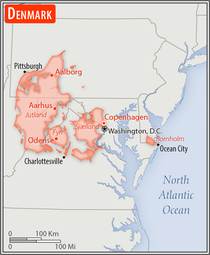
Area - comparative:
slightly less than twice the size of Massachusetts; about two-thirds the size of West Virginia
Area comparison map:
slightly less than twice the size of Massachusetts; about two-thirds the size of West Virginia
Land boundaries:
total: 140 km
[see also: Land boundaries - total country ranks ]
border countries (1):
Germany 140 km
Coastline:
7,314 km
[see also: Coastline country ranks ]
Maritime claims:
territorial sea: 12
nm
[see also: Maritime claims - territorial sea country ranks ]
exclusive economic zone: 200
nm
[see also: Maritime claims - exclusive economic zone country ranks ]
contiguous zone: 24
nm
[see also: Maritime claims - contiguous zone country ranks ]
continental shelf:
200-m depth or to the depth of exploitation
[see also: Maritime claims - continental shelf country ranks ]
Climate:
temperate; humid and overcast; mild, windy winters and cool summers
More Climate Details
Terrain:
low and flat to gently rolling plains
Elevation:
mean elevation: 34 m
[see also: Elevation - mean elevation country ranks ]
lowest point:
Lammefjord -7 m
highest point:
Mollehoj/Ejer Bavnehoj 171 m
Natural resources:
petroleum, natural gas, fish, arable land, salt, limestone, chalk, stone, gravel and sand
Land use:
agricultural land: 63.4%
(2011 est.)
[see also: Land use - agricultural land country ranks ]
arable land: 58.9%
(2011 est.)
[see also: Land use - arable land country ranks ]
permanent crops: 0.1%
(2011 est.)
[see also: Land use - permanent crops country ranks ]
permanent pasture: 4.4%
(2011 est.)
[see also: Land use - permanent pasture country ranks ]
forest: 12.9%
(2011 est.)
[see also: Land use - forest country ranks ]
other: 23.7%
(2011 est.)
note: highest percentage of arable land for any country in the world
[see also: Land use country ranks ]
Irrigated land:
4,350 sq km
(2012)
[see also: Irrigated land country ranks ]
Population distribution:
with excellent access to the North Sea, Skagerrak, Kattegat, and the Baltic Sea, population centers tend to be along coastal areas, particularly in Copenhagen and the eastern side of the country's mainland
Natural hazards:
flooding is a threat in some areas of the country (e.g., parts of Jutland, along the southern coast of the island of Lolland) that are protected from the sea by a system of dikes
Environment - current issues:
air pollution, principally from vehicle and power plant emissions; nitrogen and phosphorus pollution of the North Sea; drinking and surface water becoming polluted from animal wastes and pesticides; much of country's household and industrial waste is recycled
Environment - international agreements:
party to:
Air Pollution, Air Pollution-Nitrogen Oxides, Air Pollution-Persistent Organic Pollutants, Air Pollution-Sulfur 85, Air Pollution-Sulfur 94, Air Pollution-Volatile Organic Compounds, Antarctic Treaty, Biodiversity, Climate Change, Climate Change-Kyoto Protocol, Desertification, Endangered Species, Environmental Modification, Hazardous Wastes, Law of the Sea, Marine Dumping, Marine Life Conservation, Ozone Layer Protection, Ship Pollution, Tropical Timber 83, Tropical Timber 94, Wetlands, Whaling
signed, but not ratified:
none of the selected agreements
Geography - note:
composed of the Jutland Peninsula and a group of more than 400 islands (Danish Archipelago); controls Danish Straits (Skagerrak and Kattegat) linking Baltic and North Seas; about one-quarter of the population lives in greater Copenhagen
NOTE: 1) The information regarding Denmark on this page is re-published from the 2020 World Fact Book of the United States Central Intelligence Agency and other sources. No claims are made regarding the accuracy of Denmark Geography 2020 information contained here. All suggestions for corrections of any errors about Denmark Geography 2020 should be addressed to the CIA or the source cited on each page.
2) The rank that you see is the CIA reported rank, which may have the following issues:
a) They assign increasing rank number, alphabetically for countries with the same value of the ranked item, whereas we assign them the same rank.
b) The CIA sometimes assigns counterintuitive ranks. For example, it assigns unemployment rates in increasing order, whereas we rank them in decreasing order.
- Main Index
- 2020 Index
- Country Ranks
- Definitions
- Denmark Index 2020
- Denmark Main Index
- Introduction
- History
- Geography
- Climate
- Maps
- People
- Religion
- Government
- Gov. Leaders
- Flags
- Economy
- Energy
- Communications
- Transportation
- Airport Codes
- Military
- Transnational Issues
- Photos
- Advertise Here
- Feedback

This page was last modified 27-Jan-20