


Location:
Middle East, bordering the Gulf of Oman, the Persian Gulf, and the Caspian Sea, between Iraq and Pakistan
Geographic coordinates:
32 00 N, 53 00 E
Map references:
Middle East
Area:
total: 1,648,195 sq km
[see also: Area - total country ranks ]
land: 1,531,595 sq km
[see also: Area - land country ranks ]
water: 116,600 sq km
[see also: Area - water country ranks ]
country comparison to the world (CIA rank, may be based on non-current data):
19
Area - comparative:
almost 2.5 times the size of Texas; slightly smaller than Alaska
Area comparison map:
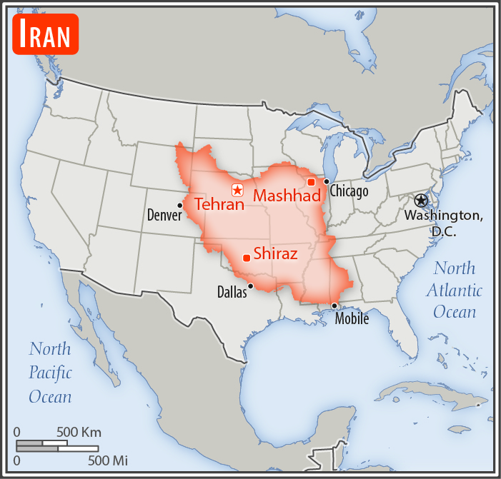
almost 2.5 times the size of Texas; slightly smaller than Alaska
Land boundaries:
total: 5,894 km
[see also: Land boundaries - total country ranks ]
border countries (7):
Afghanistan 921 km, Armenia 44 km, Azerbaijan 689 km, Iraq 1599 km, Pakistan 959 km, Turkey 534 km, Turkmenistan 1148 km
Coastline:
2,440 km
- note: Iran also borders the Caspian Sea (740 km)
[see also: Coastline country ranks ]
Maritime claims:
territorial sea: 12
nm
[see also: Maritime claims - territorial sea country ranks ]
exclusive economic zone:
bilateral agreements or median lines in the Persian Gulf
[see also: Maritime claims - exclusive economic zone country ranks ]
contiguous zone: 24
nm
[see also: Maritime claims - contiguous zone country ranks ]
continental shelf:
natural prolongation
[see also: Maritime claims - continental shelf country ranks ]
Climate:
mostly arid or semiarid, subtropical along Caspian coast
More Climate Details
Terrain:
rugged, mountainous rim; high, central basin with deserts, mountains; small, discontinuous plains along both coasts
Elevation:
mean elevation: 1,305 m
[see also: Elevation - mean elevation country ranks ]
lowest point:
Caspian Sea -28 m
highest point:
Kuh-e Damavand 5,625 m
Natural resources:
petroleum, natural gas, coal, chromium, copper, iron ore, lead, manganese, zinc, sulfur
Land use:
agricultural land: 30.1%
(2011 est.)
[see also: Land use - agricultural land country ranks ]
arable land: 10.8%
(2011 est.)
[see also: Land use - arable land country ranks ]
permanent crops: 1.2%
(2011 est.)
[see also: Land use - permanent crops country ranks ]
permanent pasture: 18.1%
(2011 est.)
[see also: Land use - permanent pasture country ranks ]
forest: 6.8%
(2011 est.)
[see also: Land use - forest country ranks ]
other: 63.1%
(2011 est.)
[see also: Land use country ranks ]
Irrigated land:
95,530 sq km
(2012)
[see also: Irrigated land country ranks ]
Population distribution:
population is concentrated in the north, northwest, and west, reflecting the position of the Zagros and Elburz Mountains; the vast dry areas in the center and eastern parts of the country, around the deserts of the Dasht-e Kavir and Dasht-e Lut, have a much lower population density
Natural hazards:
periodic droughts, floods; dust storms, sandstorms; earthquakes
Environment - current issues:
air pollution, especially in urban areas, from vehicle emissions, refinery operations, and industrial effluents; deforestation; overgrazing; desertification; oil pollution in the Persian Gulf; wetland losses from drought; soil degradation (salination); inadequate supplies of potable water; water pollution from raw sewage and industrial waste; urbanization
Environment - international agreements:
party to:
Biodiversity, Climate Change, Climate Change-Kyoto Protocol, Desertification, Endangered Species, Hazardous Wastes, Marine Dumping, Ozone Layer Protection, Ship Pollution, Wetlands
signed, but not ratified:
Environmental Modification, Law of the Sea, Marine Life Conservation
Geography - note:
strategic location on the Persian Gulf and Strait of Hormuz, which are vital maritime pathways for crude oil transport
NOTE: 1) The information regarding Iran on this page is re-published from the 2020 World Fact Book of the United States Central Intelligence Agency and other sources. No claims are made regarding the accuracy of Iran Geography 2020 information contained here. All suggestions for corrections of any errors about Iran Geography 2020 should be addressed to the CIA or the source cited on each page.
2) The rank that you see is the CIA reported rank, which may have the following issues:
a) They assign increasing rank number, alphabetically for countries with the same value of the ranked item, whereas we assign them the same rank.
b) The CIA sometimes assigns counterintuitive ranks. For example, it assigns unemployment rates in increasing order, whereas we rank them in decreasing order.
- Main Index
- 2020 Index
- Country Ranks
- Definitions
- Iran Index 2020
- Iran Main Index
- Introduction
- History
- Geography
- Climate
- Maps
- People
- Religion
- Government
- Gov. Leaders
- Flags
- Economy
- Energy
- Communications
- Transportation
- Airport Codes
- Military
- Terrorism
- Transnational Issues
- Photos
- Advertise Here
- Feedback

This page was last modified 27-Jan-20