


Location:
Northern Africa, bordering the Mediterranean Sea, between Egypt, Tunisia, and Algeria
Geographic coordinates:
25 00 N, 17 00 E
Map references:
Africa
Area:
total: 1,759,540 sq km
[see also: Area - total country ranks ]
land: 1,759,540 sq km
[see also: Area - land country ranks ]
water: 0 sq km
[see also: Area - water country ranks ]
country comparison to the world (CIA rank, may be based on non-current data):
18
Area - comparative:
about 2.5 times the size of Texas; slightly larger than Alaska
Area comparison map:
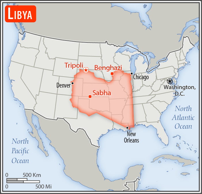
about 2.5 times the size of Texas; slightly larger than Alaska
Land boundaries:
total: 4,339 km
[see also: Land boundaries - total country ranks ]
border countries (6):
Algeria 989 km, Chad 1050 km, Egypt 1115 km, Niger 342 km, Sudan 382 km, Tunisia 461 km
Coastline:
1,770 km
[see also: Coastline country ranks ]
Maritime claims:
territorial sea: 12
nm
[see also: Maritime claims - territorial sea country ranks ]
exclusive fishing zone: 62
nm
note: Gulf of Sidra closing line - 32 degrees, 30 minutes north
Climate:
Mediterranean along coast; dry, extreme desert interior
More Climate Details
Terrain:
mostly barren, flat to undulating plains, plateaus, depressions
Elevation:
mean elevation: 423 m
[see also: Elevation - mean elevation country ranks ]
lowest point:
Sabkhat Ghuzayyil -47 m
highest point:
Bikku Bitti 2,267 m
Natural resources:
petroleum, natural gas, gypsum
Land use:
agricultural land: 8.8%
(2011 est.)
[see also: Land use - agricultural land country ranks ]
arable land: 1%
(2011 est.)
[see also: Land use - arable land country ranks ]
permanent crops: 0.2%
(2011 est.)
[see also: Land use - permanent crops country ranks ]
permanent pasture: 7.6%
(2011 est.)
[see also: Land use - permanent pasture country ranks ]
forest: 0.1%
(2011 est.)
[see also: Land use - forest country ranks ]
other: 91.1%
(2011 est.)
[see also: Land use country ranks ]
Irrigated land:
4,700 sq km
(2012)
[see also: Irrigated land country ranks ]
Population distribution:
well over 90% of the population lives along the Mediterranean coast in and between Tripoli to the west and Al Bayda to the east; the interior remains vastly underpopulated due to the Sahara and lack of surface water
Natural hazards:
hot, dry, dust-laden ghibli is a southern wind lasting one to four days in spring and fall; dust storms, sandstorms
Environment - current issues:
desertification; limited natural freshwater resources; the Great Manmade River Project, the largest water development scheme in the world, brings water from large aquifers under the Sahara to coastal cities; water pollution is a significant problem; the combined impact of sewage, oil byproducts, and industrial waste threatens Libya's coast and the Mediterranean Sea
Environment - international agreements:
party to:
Biodiversity, Climate Change, Climate Change-Kyoto Protocol, Desertification, Endangered Species, Hazardous Wastes, Marine Dumping, Ozone Layer Protection, Ship Pollution, Wetlands
signed, but not ratified:
Law of the Sea
Geography - note:
note 1: more than 90% of the country is desert or semidesert
note 2: the volcano Waw an Namus lies in south central Libya in the middle of the Sahara; the caldera is an oasis - the name means "oasis of mosquitoes" - containing several small lakes surrounded by vegetation and hosting various insects and a large diversity of birds
NOTE: 1) The information regarding Libya on this page is re-published from the 2020 World Fact Book of the United States Central Intelligence Agency and other sources. No claims are made regarding the accuracy of Libya Geography 2020 information contained here. All suggestions for corrections of any errors about Libya Geography 2020 should be addressed to the CIA or the source cited on each page.
2) The rank that you see is the CIA reported rank, which may have the following issues:
a) They assign increasing rank number, alphabetically for countries with the same value of the ranked item, whereas we assign them the same rank.
b) The CIA sometimes assigns counterintuitive ranks. For example, it assigns unemployment rates in increasing order, whereas we rank them in decreasing order.
- Main Index
- 2020 Index
- Country Ranks
- Definitions
- Libya Index 2020
- Libya Main Index
- Introduction
- History
- Geography
- Climate
- Maps
- People
- Religion
- Government
- Gov. Leaders
- Flags
- Economy
- Energy
- Communications
- Transportation
- Airport Codes
- Military
- Terrorism
- Transnational Issues
- Photos
- Advertise Here
- Feedback

This page was last modified 27-Jan-20