


Location:
Southeastern Asia, peninsula bordering Thailand and northern one-third of the island of Borneo, bordering Indonesia, Brunei, and the South China Sea, south of Vietnam
Geographic coordinates:
2 30 N, 112 30 E
Map references:
Southeast Asia
Area:
total: 329,847 sq km
[see also: Area - total country ranks ]
land: 328,657 sq km
[see also: Area - land country ranks ]
water: 1,190 sq km
[see also: Area - water country ranks ]
country comparison to the world (CIA rank, may be based on non-current data):
68
Area - comparative:
slightly larger than New Mexico
Area comparison map:
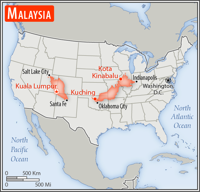
slightly larger than New Mexico
Land boundaries:
total: 2,742 km
[see also: Land boundaries - total country ranks ]
border countries (3):
Brunei 266 km, Indonesia 1881 km, Thailand 595 km
Coastline:
4,675 km
(Peninsular Malaysia 2,068 km, East Malaysia 2,607 km)
[see also: Coastline country ranks ]
Maritime claims:
territorial sea: 12
nm
[see also: Maritime claims - territorial sea country ranks ]
exclusive economic zone: 200
nm
[see also: Maritime claims - exclusive economic zone country ranks ]
continental shelf:
200-m depth or to the depth of exploitation; specified boundary in the South China Sea
[see also: Maritime claims - continental shelf country ranks ]
Climate:
tropical; annual southwest (April to October) and northeast (October to February) monsoons
More Climate Details
Terrain:
coastal plains rising to hills and mountains
Elevation:
mean elevation: 419 m
[see also: Elevation - mean elevation country ranks ]
lowest point:
Indian Ocean 0 m
highest point:
Gunung Kinabalu 4,095 m
Natural resources:
tin, petroleum, timber, copper, iron ore, natural gas, bauxite
Land use:
agricultural land: 23.2%
(2011 est.)
[see also: Land use - agricultural land country ranks ]
arable land: 2.9%
(2011 est.)
[see also: Land use - arable land country ranks ]
permanent crops: 19.4%
(2011 est.)
[see also: Land use - permanent crops country ranks ]
permanent pasture: 0.9%
(2011 est.)
[see also: Land use - permanent pasture country ranks ]
forest: 62%
(2011 est.)
[see also: Land use - forest country ranks ]
other: 14.8%
(2011 est.)
[see also: Land use country ranks ]
Irrigated land:
3,800 sq km
(2012)
[see also: Irrigated land country ranks ]
Population distribution:
a highly uneven distribution with over 80% of the population residing on the Malay Peninsula
Natural hazards:
flooding; landslides; forest fires
Environment - current issues:
air pollution from industrial and vehicular emissions; water pollution from raw sewage; deforestation; smoke/haze from Indonesian forest fires; endangered species; coastal reclamation damaging mangroves and turtle nesting sites
Environment - international agreements:
party to:
Biodiversity, Climate Change, Climate Change-Kyoto Protocol, Desertification, Endangered Species, Hazardous Wastes, Law of the Sea, Marine Life Conservation, Ozone Layer Protection, Ship Pollution, Tropical Timber 83, Tropical Timber 94, Wetlands
signed, but not ratified:
none of the selected agreements
Geography - note:
strategic location along Strait of Malacca and southern South China Sea
NOTE: 1) The information regarding Malaysia on this page is re-published from the 2020 World Fact Book of the United States Central Intelligence Agency and other sources. No claims are made regarding the accuracy of Malaysia Geography 2020 information contained here. All suggestions for corrections of any errors about Malaysia Geography 2020 should be addressed to the CIA or the source cited on each page.
2) The rank that you see is the CIA reported rank, which may have the following issues:
a) They assign increasing rank number, alphabetically for countries with the same value of the ranked item, whereas we assign them the same rank.
b) The CIA sometimes assigns counterintuitive ranks. For example, it assigns unemployment rates in increasing order, whereas we rank them in decreasing order.
- Main Index
- 2020 Index
- Country Ranks
- Definitions
- Malaysia Index 2020
- Malaysia Main Index
- Introduction
- History
- Geography
- Climate
- Maps
- People
- Religion
- Government
- Gov. Leaders
- Flags
- Economy
- Energy
- Communications
- Transportation
- Airport Codes
- Military
- Terrorism
- Transnational Issues
- Photos
- Advertise Here
- Feedback

This page was last modified 27-Jan-20