


Location:
Southern Africa, bordering the South Atlantic Ocean, between Angola and South Africa
Geographic coordinates:
22 00 S, 17 00 E
Map references:
Africa
Area:
total: 824,292 sq km
[see also: Area - total country ranks ]
land: 823,290 sq km
[see also: Area - land country ranks ]
water: 1,002 sq km
[see also: Area - water country ranks ]
country comparison to the world (CIA rank, may be based on non-current data):
35
Area - comparative:
almost seven times the size of Pennsylvania; slightly more than half the size of Alaska
Area comparison map:
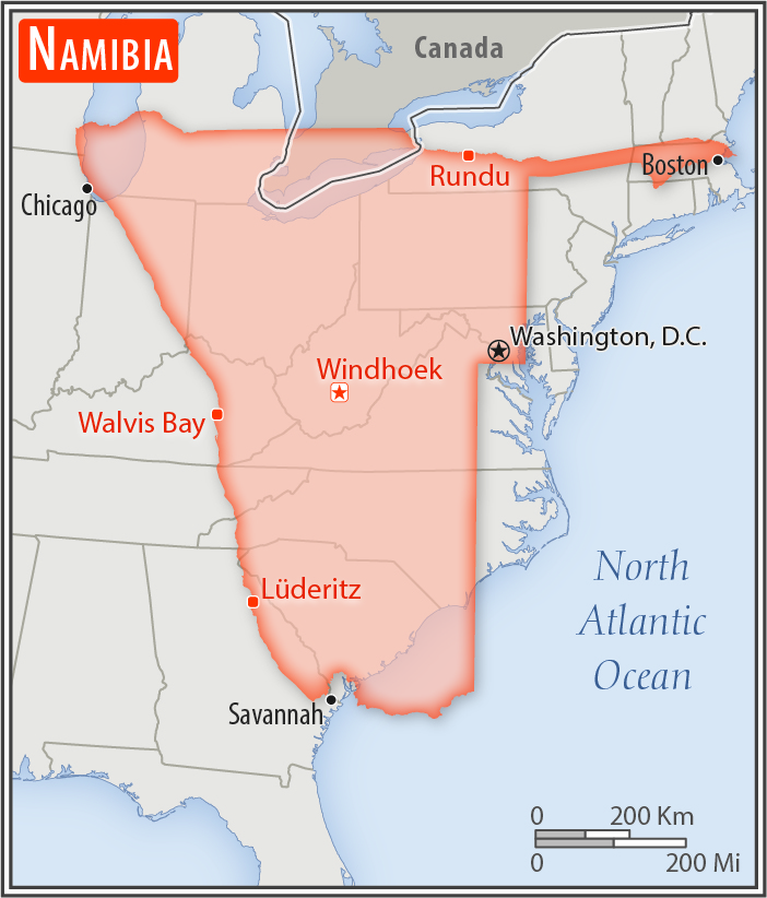
almost seven times the size of Pennsylvania; slightly more than half the size of Alaska
Land boundaries:
total: 4,220 km
[see also: Land boundaries - total country ranks ]
border countries (4):
Angola 1427 km, Botswana 1544 km, South Africa 1005 km, Zambia 244 km
Coastline:
1,572 km
[see also: Coastline country ranks ]
Maritime claims:
territorial sea: 12
nm
[see also: Maritime claims - territorial sea country ranks ]
exclusive economic zone: 200
nm
[see also: Maritime claims - exclusive economic zone country ranks ]
contiguous zone: 24
nm
[see also: Maritime claims - contiguous zone country ranks ]
Climate:
desert; hot, dry; rainfall sparse and erratic
Terrain:
mostly high plateau; Namib Desert along coast; Kalahari Desert in east
Elevation:
mean elevation: 1,141 m
[see also: Elevation - mean elevation country ranks ]
lowest point:
Atlantic Ocean 0 m
highest point:
Konigstein on Brandberg 2,573 m
Natural resources:
diamonds, copper, uranium, gold, silver, lead, tin, lithium, cadmium, tungsten, zinc, salt, hydropower, fish, note, suspected deposits of oil, coal, and iron ore
Land use:
agricultural land: 47.2%
(2011 est.)
[see also: Land use - agricultural land country ranks ]
arable land: 1%
(2011 est.)
[see also: Land use - arable land country ranks ]
permanent crops: 0%
(2011 est.)
[see also: Land use - permanent crops country ranks ]
permanent pasture: 46.2%
(2011 est.)
[see also: Land use - permanent pasture country ranks ]
forest: 8.8%
(2011 est.)
[see also: Land use - forest country ranks ]
other: 44%
(2011 est.)
[see also: Land use country ranks ]
Irrigated land:
80 sq km
(2012)
[see also: Irrigated land country ranks ]
Population distribution:
population density is very low, with the largest clustering found in the extreme north-central area along the border with Angola
Natural hazards:
prolonged periods of drought
Environment - current issues:
depletion and degradation of water and aquatic resources; desertification; land degradation; loss of biodiversity and biotic resources; wildlife poaching
Environment - international agreements:
party to:
Antarctic-Marine Living Resources, Biodiversity, Climate Change, Climate Change-Kyoto Protocol, Desertification, Endangered Species, Hazardous Wastes, Law of the Sea, Ozone Layer Protection, Wetlands
signed, but not ratified:
none of the selected agreements
Geography - note:
the Namib Desert, after which the country is named, is considered to be the oldest desert in the world; Namibia is the first country in the world to incorporate the protection of the environment into its constitution; some 14% of the land is protected, including virtually the entire Namib Desert coastal strip; Namib-Naukluft National Park (49,768 sq km), is the largest game park in Africa and one of the largest in the world
NOTE: 1) The information regarding Namibia on this page is re-published from the 2020 World Fact Book of the United States Central Intelligence Agency and other sources. No claims are made regarding the accuracy of Namibia Geography 2020 information contained here. All suggestions for corrections of any errors about Namibia Geography 2020 should be addressed to the CIA or the source cited on each page.
2) The rank that you see is the CIA reported rank, which may have the following issues:
a) They assign increasing rank number, alphabetically for countries with the same value of the ranked item, whereas we assign them the same rank.
b) The CIA sometimes assigns counterintuitive ranks. For example, it assigns unemployment rates in increasing order, whereas we rank them in decreasing order.
- Main Index
- 2020 Index
- Country Ranks
- Definitions
- Namibia Index 2020
- Namibia Main Index
- Introduction
- History
- Geography
- Maps
- People
- Religion
- Government
- Gov. Leaders
- Flags
- Economy
- Energy
- Communications
- Transportation
- Airport Codes
- Military
- Transnational Issues
- Photos
- Advertise Here
- Feedback

This page was last modified 27-Jan-20