


Location:
Central America, bordering both the Caribbean Sea and the North Pacific Ocean, between Colombia and Costa Rica
Geographic coordinates:
9 00 N, 80 00 W
Map references:
Central America and the Caribbean
Area:
total: 75,420 sq km
[see also: Area - total country ranks ]
land: 74,340 sq km
[see also: Area - land country ranks ]
water: 1,080 sq km
[see also: Area - water country ranks ]
country comparison to the world (CIA rank, may be based on non-current data):
119
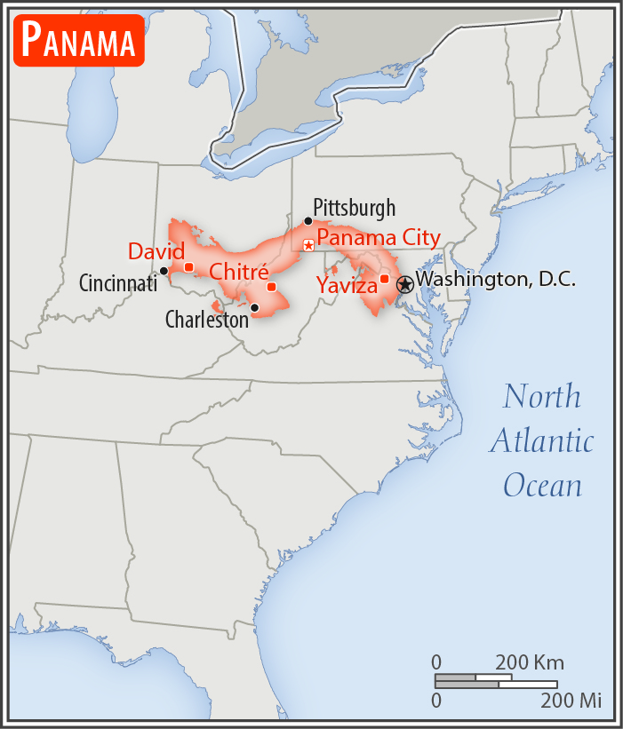
Area - comparative:
slightly smaller than South Carolina
Area comparison map:
slightly smaller than South Carolina
Land boundaries:
total: 687 km
[see also: Land boundaries - total country ranks ]
border countries (2):
Colombia 339 km, Costa Rica 348 km
Coastline:
2,490 km
[see also: Coastline country ranks ]
Maritime claims:
territorial sea: 12
nm
[see also: Maritime claims - territorial sea country ranks ]
exclusive economic zone: 200
nm or edge of continental margin
[see also: Maritime claims - exclusive economic zone country ranks ]
contiguous zone: 24
nm
[see also: Maritime claims - contiguous zone country ranks ]
Climate:
tropical maritime; hot, humid, cloudy; prolonged rainy season (May to January), short dry season (January to May)
More Climate Details
Terrain:
interior mostly steep, rugged mountains with dissected, upland plains; coastal plains with rolling hills
Elevation:
mean elevation: 360 m
[see also: Elevation - mean elevation country ranks ]
lowest point:
Pacific Ocean 0 m
highest point:
Volcan Baru 3,475 m
Natural resources:
copper, mahogany forests, shrimp, hydropower
Land use:
agricultural land: 30.5%
(2011 est.)
[see also: Land use - agricultural land country ranks ]
arable land: 7.3%
(2011 est.)
[see also: Land use - arable land country ranks ]
permanent crops: 2.5%
(2011 est.)
[see also: Land use - permanent crops country ranks ]
permanent pasture: 20.7%
(2011 est.)
[see also: Land use - permanent pasture country ranks ]
forest: 43.6%
(2011 est.)
[see also: Land use - forest country ranks ]
other: 25.9%
(2011 est.)
[see also: Land use country ranks ]
Irrigated land:
321 sq km
(2012)
[see also: Irrigated land country ranks ]
Population distribution:
population is concentrated towards the center of the country, particularly around the Canal, but a sizeable segment of the populace also lives in the far west around David; the eastern third of the country is sparsely inhabited
Natural hazards:
occasional severe storms and forest fires in the Darien area
Environment - current issues:
water pollution from agricultural runoff threatens fishery resources; deforestation of tropical rain forest; land degradation and soil erosion threatens siltation of Panama Canal; air pollution in urban areas; mining threatens natural resources
Environment - international agreements:
party to:
Biodiversity, Climate Change, Climate Change-Kyoto Protocol, Desertification, Endangered Species, Environmental Modification, Hazardous Wastes, Law of the Sea, Marine Dumping, Ozone Layer Protection, Ship Pollution, Tropical Timber 83, Tropical Timber 94, Wetlands, Whaling
signed, but not ratified:
Marine Life Conservation
Geography - note:
strategic location on eastern end of isthmus forming land bridge connecting North and South America; controls Panama Canal that links North Atlantic Ocean via Caribbean Sea with North Pacific Ocean
NOTE: 1) The information regarding Panama on this page is re-published from the 2020 World Fact Book of the United States Central Intelligence Agency and other sources. No claims are made regarding the accuracy of Panama Geography 2020 information contained here. All suggestions for corrections of any errors about Panama Geography 2020 should be addressed to the CIA or the source cited on each page.
2) The rank that you see is the CIA reported rank, which may have the following issues:
a) They assign increasing rank number, alphabetically for countries with the same value of the ranked item, whereas we assign them the same rank.
b) The CIA sometimes assigns counterintuitive ranks. For example, it assigns unemployment rates in increasing order, whereas we rank them in decreasing order.
- Main Index
- 2020 Index
- Country Ranks
- Definitions
- Panama Index 2020
- Panama Main Index
- Introduction
- History
- Geography
- Climate
- Maps
- People
- Religion
- Government
- Gov. Leaders
- Flags
- Economy
- Energy
- Communications
- Transportation
- Airport Codes
- Military
- Transnational Issues
- Photos
- Advertise Here
- Feedback

This page was last modified 27-Jan-20