


Location:
Central South America, northeast of Argentina, southwest of Brazil
Geographic coordinates:
23 00 S, 58 00 W
Map references:
South America
Area:
total: 406,752 sq km
[see also: Area - total country ranks ]
land: 397,302 sq km
[see also: Area - land country ranks ]
water: 9,450 sq km
[see also: Area - water country ranks ]
country comparison to the world (CIA rank, may be based on non-current data):
61
Area - comparative:
about three times the size of New York state; slightly smaller than California
Area comparison map:
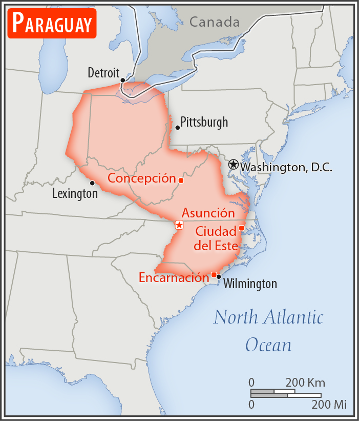
about three times the size of New York state; slightly smaller than California
Land boundaries:
total: 4,655 km
[see also: Land boundaries - total country ranks ]
border countries (3):
Argentina 2531 km, Bolivia 753 km, Brazil 1371 km
Coastline:
0 km
(landlocked)
[see also: Coastline country ranks ]
Maritime claims:
none (landlocked)
Climate:
subtropical to temperate; substantial rainfall in the eastern portions, becoming semiarid in the far west
More Climate Details
Terrain:
grassy plains and wooded hills east of Rio Paraguay; Gran Chaco region west of Rio Paraguay mostly low, marshy plain near the river, and dry forest and thorny scrub elsewhere
Elevation:
mean elevation: 178 m
[see also: Elevation - mean elevation country ranks ]
lowest point:
junction of Rio Paraguay and Rio Parana 46 m
highest point:
Cerro Pero 842 m
Natural resources:
hydropower, timber, iron ore, manganese, limestone
Land use:
agricultural land: 53.8%
(2011 est.)
[see also: Land use - agricultural land country ranks ]
arable land: 10.8%
(2011 est.)
[see also: Land use - arable land country ranks ]
permanent crops: 0.2%
(2011 est.)
[see also: Land use - permanent crops country ranks ]
permanent pasture: 42.8%
(2011 est.)
[see also: Land use - permanent pasture country ranks ]
forest: 43.8%
(2011 est.)
[see also: Land use - forest country ranks ]
other: 2.4%
(2011 est.)
[see also: Land use country ranks ]
Irrigated land:
1,362 sq km
(2012)
[see also: Irrigated land country ranks ]
Population distribution:
most of the population resides in the eastern half of the country; to the west lies the Gran Chaco (a semi-arid lowland plain), which accounts for 60% of the land territory, but only 2% of the overall population
Natural hazards:
local flooding in southeast (early September to June); poorly drained plains may become boggy (early October to June)
Environment - current issues:
deforestation; water pollution; rivers suffer from toxic dumping; tanneries release mercury and chromium into rivers and streams; loss of wetlands; inadequate means for waste disposal pose health risks for many urban residents
Environment - international agreements:
party to:
Biodiversity, Climate Change, Climate Change-Kyoto Protocol, Desertification, Endangered Species, Hazardous Wastes, Law of the Sea, Ozone Layer Protection, Wetlands
signed, but not ratified:
none of the selected agreements
Geography - note:
landlocked; lies between Argentina, Bolivia, and Brazil; population concentrated in eastern and southern part of country
NOTE: 1) The information regarding Paraguay on this page is re-published from the 2020 World Fact Book of the United States Central Intelligence Agency and other sources. No claims are made regarding the accuracy of Paraguay Geography 2020 information contained here. All suggestions for corrections of any errors about Paraguay Geography 2020 should be addressed to the CIA or the source cited on each page.
2) The rank that you see is the CIA reported rank, which may have the following issues:
a) They assign increasing rank number, alphabetically for countries with the same value of the ranked item, whereas we assign them the same rank.
b) The CIA sometimes assigns counterintuitive ranks. For example, it assigns unemployment rates in increasing order, whereas we rank them in decreasing order.
- Main Index
- 2020 Index
- Country Ranks
- Definitions
- Paraguay Index 2020
- Paraguay Main Index
- Introduction
- History
- Geography
- Climate
- Maps
- People
- Religion
- Government
- Gov. Leaders
- Flags
- Economy
- Energy
- Communications
- Transportation
- Airport Codes
- Military
- Transnational Issues
- Photos
- Advertise Here
- Feedback

This page was last modified 27-Jan-20