


Location:
North Asia bordering the Arctic Ocean, extending from Europe (the portion west of the Urals) to the North Pacific Ocean
Geographic coordinates:
60 00 N, 100 00 E
Map references:
Asia
Area:
total: 17,098,242 sq km
[see also: Area - total country ranks ]
land: 16,377,742 sq km
[see also: Area - land country ranks ]
water: 720,500 sq km
[see also: Area - water country ranks ]
country comparison to the world (CIA rank, may be based on non-current data):
1
Area - comparative:
approximately 1.8 times the size of the US
Area comparison map:
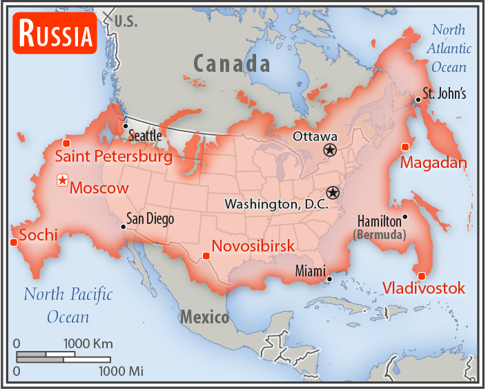
approximately 1.8 times the size of the US
Land boundaries:
total: 22,408 km
[see also: Land boundaries - total country ranks ]
border countries (15):
Azerbaijan 338 km, Belarus 1312 km, China (southeast) 4133 km, China (south) 46 km, Estonia 324 km, Finland 1309 km, Georgia 894 km, Kazakhstan 7644 km, North Korea 18 km, Latvia 332 km, Lithuania (Kaliningrad Oblast) 261 km, Mongolia 3452 km, Norway 191 km, Poland (Kaliningrad Oblast) 210 km, Ukraine 1944 km
Coastline:
37,653 km
[see also: Coastline country ranks ]
Maritime claims:
territorial sea: 12
nm
[see also: Maritime claims - territorial sea country ranks ]
exclusive economic zone: 200
nm
[see also: Maritime claims - exclusive economic zone country ranks ]
contiguous zone: 24
nm
[see also: Maritime claims - contiguous zone country ranks ]
continental shelf:
200-m depth or to the depth of exploitation
[see also: Maritime claims - continental shelf country ranks ]
Climate:
ranges from steppes in the south through humid continental in much of European Russia; subarctic in Siberia to tundra climate in the polar north; winters vary from cool along Black Sea coast to frigid in Siberia; summers vary from warm in the steppes to cool along Arctic coast
More Climate Details
Terrain:
broad plain with low hills west of Urals; vast coniferous forest and tundra in Siberia; uplands and mountains along southern border regions
Elevation:
mean elevation: 600 m
[see also: Elevation - mean elevation country ranks ]
lowest point:
Caspian Sea -28 m
highest point:
Gora El'brus (highest point in Europe) 5,642 m
Natural resources:
wide natural resource base including major deposits of oil, natural gas, coal, and many strategic minerals, bauxite, reserves of rare earth elements, timber, note, formidable obstacles of climate, terrain, and distance hinder exploitation of natural resources
Land use:
agricultural land: 13.1%
(2011 est.)
[see also: Land use - agricultural land country ranks ]
arable land: 7.3%
(2011 est.)
[see also: Land use - arable land country ranks ]
permanent crops: 0.1%
(2011 est.)
[see also: Land use - permanent crops country ranks ]
permanent pasture: 5.7%
(2011 est.)
[see also: Land use - permanent pasture country ranks ]
forest: 49.4%
(2011 est.)
[see also: Land use - forest country ranks ]
other: 37.5%
(2011 est.)
[see also: Land use country ranks ]
Irrigated land:
43,000 sq km
(2012)
[see also: Irrigated land country ranks ]
Population distribution:
population is heavily concentrated in the westernmost fifth of the country extending from the Baltic Sea, south to the Caspian Sea, and eastward parallel to the Kazakh border; elsewhere, sizeable pockets are isolated and generally found in the south
Natural hazards:
permafrost over much of Siberia is a major impediment to development; volcanic activity in the Kuril Islands; volcanoes and earthquakes on the Kamchatka Peninsula; spring floods and summer/autumn forest fires throughout Siberia and parts of European Russia
volcanism: significant volcanic activity on the Kamchatka Peninsula and Kuril Islands; the peninsula alone is home to some 29 historically active volcanoes, with dozens more in the Kuril Islands; Kliuchevskoi (4,835 m), which erupted in 2007 and 2010, is Kamchatka's most active volcano; Avachinsky and Koryaksky volcanoes, which pose a threat to the city of Petropavlovsk-Kamchatsky, have been deemed Decade Volcanoes by the International Association of Volcanology and Chemistry of the Earth's Interior, worthy of study due to their explosive history and close proximity to human populations; other notable historically active volcanoes include Bezymianny, Chikurachki, Ebeko, Gorely, Grozny, Karymsky, Ketoi, Kronotsky, Ksudach, Medvezhia, Mutnovsky, Sarychev Peak, Shiveluch, Tiatia, Tolbachik, and Zheltovsky; see note 2 under "Geography - note"
Environment - current issues:
air pollution from heavy industry, emissions of coal-fired electric plants, and transportation in major cities; industrial, municipal, and agricultural pollution of inland waterways and seacoasts; deforestation; soil erosion; soil contamination from improper application of agricultural chemicals; nuclear waste disposal; scattered areas of sometimes intense radioactive contamination; groundwater contamination from toxic waste; urban solid waste management; abandoned stocks of obsolete pesticides
Environment - international agreements:
party to:
Air Pollution, Air Pollution-Nitrogen Oxides, Air Pollution-Sulfur 85, Antarctic-Environmental Protocol, Antarctic-Marine Living Resources, Antarctic Seals, Antarctic Treaty, Biodiversity, Climate Change, Climate Change-Kyoto Protocol, Desertification, Endangered Species, Environmental Modification, Hazardous Wastes, Law of the Sea, Marine Dumping, Ozone Layer Protection, Ship Pollution, Tropical Timber 83, Wetlands, Whaling
signed, but not ratified:
Air Pollution-Sulfur 94
note 1: largest country in the world in terms of area but unfavorably located in relation to major sea lanes of the world; despite its size, much of the country lacks proper soils and climates (either too cold or too dry) for agriculture
note 2: Russia's far east, particularly the Kamchatka Peninsula, lies along the Ring of Fire, a belt of active volcanoes and earthquake epicenters bordering the Pacific Ocean; up to 90% of the world's earthquakes and some 75% of the world's volcanoes occur within the Ring of Fire
note 3: Mount El'brus is Europe's tallest peak; Lake Baikal, the deepest lake in the world, is estimated to hold one fifth of the world's fresh surface water
note 4: Kaliningrad oblast is an exclave annexed from Germany following World War II (it was formerly part of East Prussia); its capital city of Kaliningrad - formerly Koenigsberg - is the only Baltic port in Russia that remains ice free in the winter
NOTE: 1) The information regarding Russia on this page is re-published from the 2020 World Fact Book of the United States Central Intelligence Agency and other sources. No claims are made regarding the accuracy of Russia Geography 2020 information contained here. All suggestions for corrections of any errors about Russia Geography 2020 should be addressed to the CIA or the source cited on each page.
2) The rank that you see is the CIA reported rank, which may have the following issues:
a) They assign increasing rank number, alphabetically for countries with the same value of the ranked item, whereas we assign them the same rank.
b) The CIA sometimes assigns counterintuitive ranks. For example, it assigns unemployment rates in increasing order, whereas we rank them in decreasing order.
- Main Index
- 2020 Index
- Country Ranks
- Definitions
- Russia Index 2020
- Russia Main Index
- Introduction
- History
- Geography
- Climate
- Maps
- People
- Religion
- Government
- Gov. Leaders
- Flags
- Economy
- Energy
- Communications
- Transportation
- Airport Codes
- Military
- Terrorism
- Transnational Issues
- Photos
- Advertise Here
- Feedback

This page was last modified 27-Jan-20