


Location:
Southeastern Asia, islands between Malaysia and Indonesia
Geographic coordinates:
1 22 N, 103 48 E
Map references:
Southeast Asia
Area:
total: 719.2 sq km
[see also: Area - total country ranks ]
land: 709.2 sq km
[see also: Area - land country ranks ]
water: 10 sq km
[see also: Area - water country ranks ]
country comparison to the world (CIA rank, may be based on non-current data):
191
Area - comparative:
slightly more than 3.5 times the size of Washington, DC
Area comparison map:
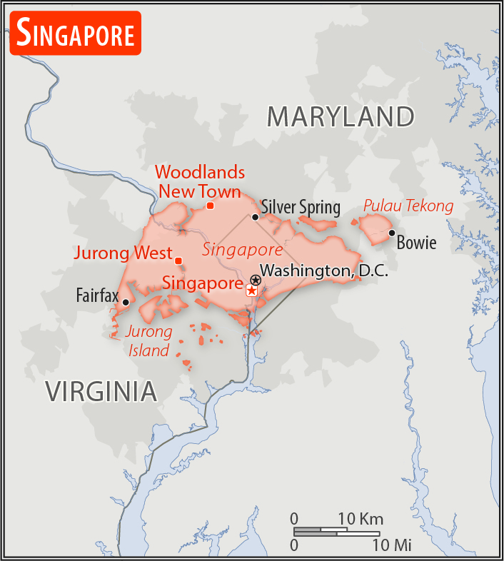
slightly more than 3.5 times the size of Washington, DC
Land boundaries:
0 km
Coastline:
193 km
[see also: Coastline country ranks ]
Maritime claims:
territorial sea: 3
nm
[see also: Maritime claims - territorial sea country ranks ]
exclusive fishing zone:
within and beyond territorial sea, as defined in treaties and practice
Climate:
tropical; hot, humid, rainy; two distinct monsoon seasons - northeastern monsoon (December to March) and southwestern monsoon (June to September); inter-monsoon - frequent afternoon and early evening thunderstorms
More Climate Details
Terrain:
lowlying, gently undulating central plateau
Elevation:
lowest point:
Singapore Strait 0 m
highest point:
Bukit Timah 166 m
Natural resources:
fish, deepwater ports
Land use:
agricultural land: 1%
(2011 est.)
[see also: Land use - agricultural land country ranks ]
arable land: 0.9%
(2011 est.)
[see also: Land use - arable land country ranks ]
permanent crops: 0.1%
(2011 est.)
[see also: Land use - permanent crops country ranks ]
permanent pasture: 0%
(2011 est.)
[see also: Land use - permanent pasture country ranks ]
forest: 3.3%
(2011 est.)
[see also: Land use - forest country ranks ]
other: 95.7%
(2011 est.)
[see also: Land use country ranks ]
Irrigated land:
0 sq km
(2012)
[see also: Irrigated land country ranks ]
Population distribution:
most of the urbanization is along the southern coast, with relatively dense population clusters found in the central areas
Natural hazards:
flash floods
Environment - current issues:
water pollution; industrial pollution; limited natural freshwater resources; limited land availability presents waste disposal problems; air pollution; deforestation; seasonal smoke/haze resulting from forest fires in Indonesia
Environment - international agreements:
party to:
Biodiversity, Climate Change, Climate Change-Kyoto Protocol, Desertification, Endangered Species, Hazardous Wastes, Law of the Sea, Ozone Layer Protection, Ship Pollution
signed, but not ratified:
none of the selected agreements
Geography - note:
focal point for Southeast Asian sea routes; consists of about 60 islands, by far the largest of which is Pulau Ujong; land reclamation has removed many former islands and created a number of new ones
NOTE: 1) The information regarding Singapore on this page is re-published from the 2020 World Fact Book of the United States Central Intelligence Agency and other sources. No claims are made regarding the accuracy of Singapore Geography 2020 information contained here. All suggestions for corrections of any errors about Singapore Geography 2020 should be addressed to the CIA or the source cited on each page.
2) The rank that you see is the CIA reported rank, which may have the following issues:
a) They assign increasing rank number, alphabetically for countries with the same value of the ranked item, whereas we assign them the same rank.
b) The CIA sometimes assigns counterintuitive ranks. For example, it assigns unemployment rates in increasing order, whereas we rank them in decreasing order.
- Main Index
- 2020 Index
- Country Ranks
- Definitions
- Singapore Index 2020
- Singapore Main Index
- Introduction
- History
- Geography
- Climate
- Maps
- People
- Religion
- Government
- Gov. Leaders
- Flags
- Economy
- Energy
- Communications
- Transportation
- Airport Codes
- Military
- Terrorism
- Transnational Issues
- Photos
- Advertise Here
- Feedback

This page was last modified 27-Jan-20