


Location:
Southern Africa, at the southern tip of the continent of Africa
Geographic coordinates:
29 00 S, 24 00 E
Map references:
Africa
Area:
total: 1,219,090 sq km
[see also: Area - total country ranks ]
land: 1,214,470 sq km
[see also: Area - land country ranks ]
water: 4,620 sq km
note: includes Prince Edward Islands (Marion Island and Prince Edward Island)
country comparison to the world (CIA rank, may be based on non-current data):
26
Area - comparative:
slightly less than twice the size of Texas
Area comparison map:
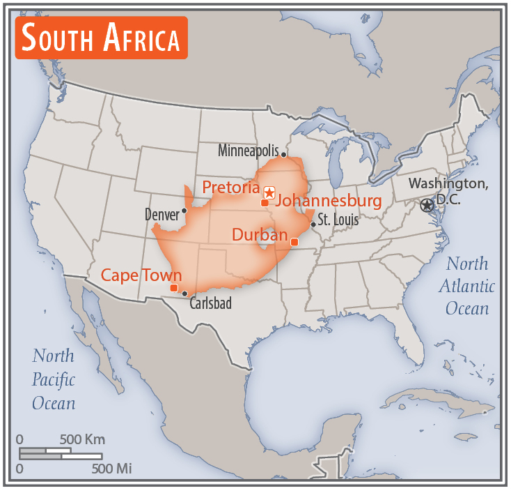
slightly less than twice the size of Texas
Land boundaries:
total: 5,244 km
[see also: Land boundaries - total country ranks ]
border countries (6):
Botswana 1969 km, Lesotho 1106 km, Mozambique 496 km, Namibia 1005 km, Eswatini 438 km, Zimbabwe 230 km
Coastline:
2,798 km
[see also: Coastline country ranks ]
Maritime claims:
territorial sea: 12
nm
[see also: Maritime claims - territorial sea country ranks ]
exclusive economic zone: 200
nm
[see also: Maritime claims - exclusive economic zone country ranks ]
contiguous zone: 24
nm
[see also: Maritime claims - contiguous zone country ranks ]
continental shelf: 200
nm or to edge of the continental margin
[see also: Maritime claims - continental shelf country ranks ]
Climate:
mostly semiarid; subtropical along east coast; sunny days, cool nights
More Climate Details
Terrain:
vast interior plateau rimmed by rugged hills and narrow coastal plain
Elevation:
mean elevation: 1,034 m
[see also: Elevation - mean elevation country ranks ]
lowest point:
Atlantic Ocean 0 m
highest point:
Njesuthi 3,408 m
Natural resources:
gold, chromium, antimony, coal, iron ore, manganese, nickel, phosphates, tin, rare earth elements, uranium, gem diamonds, platinum, copper, vanadium, salt, natural gas
Land use:
agricultural land: 79.4%
(2011 est.)
[see also: Land use - agricultural land country ranks ]
arable land: 9.9%
(2011 est.)
[see also: Land use - arable land country ranks ]
permanent crops: 0.3%
(2011 est.)
[see also: Land use - permanent crops country ranks ]
permanent pasture: 69.2%
(2011 est.)
[see also: Land use - permanent pasture country ranks ]
forest: 7.6%
(2011 est.)
[see also: Land use - forest country ranks ]
other: 13%
(2011 est.)
[see also: Land use country ranks ]
Irrigated land:
16,700 sq km
(2012)
[see also: Irrigated land country ranks ]
Population distribution:
the population concentrated along the southern and southeastern coast, and inland around Pretoria; the eastern half of the country is more densly populated than the west
Natural hazards:
prolonged droughts
volcanism: the volcano forming Marion Island in the Prince Edward Islands, which last erupted in 2004, is South Africa's only active volcano
Environment - current issues:
lack of important arterial rivers or lakes requires extensive water conservation and control measures; growth in water usage outpacing supply; pollution of rivers from agricultural runoff and urban discharge; air pollution resulting in acid rain; deforestation; soil erosion; land degradation; desertification; solid waste pollution; disruption of fragile ecosystem has resulted in significant floral extinctions
Environment - international agreements:
party to:
Antarctic-Environmental Protocol, Antarctic-Marine Living Resources, Antarctic Seals, Antarctic Treaty, Biodiversity, Climate Change, Climate Change-Kyoto Protocol, Desertification, Endangered Species, Hazardous Wastes, Law of the Sea, Marine Dumping, Marine Life Conservation, Ozone Layer Protection, Ship Pollution, Wetlands, Whaling
signed, but not ratified:
none of the selected agreements
Geography - note:
South Africa completely surrounds Lesotho and almost completely surrounds Eswatini
NOTE: 1) The information regarding South Africa on this page is re-published from the 2020 World Fact Book of the United States Central Intelligence Agency and other sources. No claims are made regarding the accuracy of South Africa Geography 2020 information contained here. All suggestions for corrections of any errors about South Africa Geography 2020 should be addressed to the CIA or the source cited on each page.
2) The rank that you see is the CIA reported rank, which may have the following issues:
a) They assign increasing rank number, alphabetically for countries with the same value of the ranked item, whereas we assign them the same rank.
b) The CIA sometimes assigns counterintuitive ranks. For example, it assigns unemployment rates in increasing order, whereas we rank them in decreasing order.
- Main Index
- 2020 Index
- Country Ranks
- Definitions
- South Africa Index 2020
- South Africa Main Index
- Introduction
- History
- Geography
- Climate
- Maps
- People
- Religion
- Government
- Gov. Leaders
- Flags
- Economy
- Energy
- Communications
- Transportation
- Airport Codes
- Military
- Transnational Issues
- Photos
- Advertise Here
- Feedback

This page was last modified 27-Jan-20