


Location:
Central Asia, bordering the Caspian Sea, between Iran and Kazakhstan
Geographic coordinates:
40 00 N, 60 00 E
Map references:
Asia
Area:
total: 488,100 sq km
[see also: Area - total country ranks ]
land: 469,930 sq km
[see also: Area - land country ranks ]
water: 18,170 sq km
[see also: Area - water country ranks ]
country comparison to the world (CIA rank, may be based on non-current data):
54
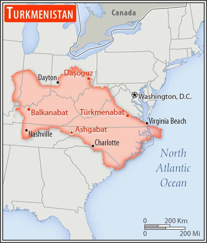
Area - comparative:
slightly more than three times the size of Georgia; slightly larger than California
Area comparison map:
slightly more than three times the size of Georgia; slightly larger than California
Land boundaries:
total: 4,158 km
[see also: Land boundaries - total country ranks ]
border countries (4):
Afghanistan 804 km, Iran 1148 km, Kazakhstan 413 km, Uzbekistan 1793 km
Coastline:
0 km
(landlocked); note - Turkmenistan borders the Caspian Sea (1,768 km)
[see also: Coastline country ranks ]
Maritime claims:
none (landlocked)
Climate:
subtropical desert
More Climate Details
Terrain:
flat-to-rolling sandy desert with dunes rising to mountains in the south; low mountains along border with Iran; borders Caspian Sea in west
Elevation:
mean elevation: 230 m
[see also: Elevation - mean elevation country ranks ]
lowest point:
Vpadina Akchanaya (Sarygamysh Koli is a lake in northern Turkmenistan with a water level that fluctuates above and below the elevation of Vpadina Akchanaya, the lake has dropped as low as -110 m) -81 m
highest point:
Gora Ayribaba 3,139 m
Natural resources:
petroleum, natural gas, sulfur, salt
Land use:
agricultural land: 72%
(2011 est.)
[see also: Land use - agricultural land country ranks ]
arable land: 4.1%
(2011 est.)
[see also: Land use - arable land country ranks ]
permanent crops: 0.1%
(2011 est.)
[see also: Land use - permanent crops country ranks ]
permanent pasture: 67.8%
(2011 est.)
[see also: Land use - permanent pasture country ranks ]
forest: 8.8%
(2011 est.)
[see also: Land use - forest country ranks ]
other: 19.2%
(2011 est.)
[see also: Land use country ranks ]
Irrigated land:
19,950 sq km
(2012)
[see also: Irrigated land country ranks ]
Population distribution:
the most densely populated areas are the southern, eastern, and northeastern oases; approximately 50% of the population lives in and around the capital of Ashgabat
Natural hazards:
earthquakes; mudslides; droughts; dust storms; floods
Environment - current issues:
contamination of soil and groundwater with agricultural chemicals, pesticides; salination, water logging of soil due to poor irrigation methods; Caspian Sea pollution; diversion of a large share of the flow of the Amu Darya into irrigation contributes to that river's inability to replenish the Aral Sea; soil erosion; desertification
Environment - international agreements:
party to:
Biodiversity, Climate Change, Climate Change-Kyoto Protocol, Desertification, Hazardous Wastes, Ozone Layer Protection
signed, but not ratified:
none of the selected agreements
Geography - note:
landlocked; the western and central low-lying desolate portions of the country make up the great Garagum (Kara-Kum) desert, which occupies over 80% of the country; eastern part is plateau
NOTE: 1) The information regarding Turkmenistan on this page is re-published from the 2020 World Fact Book of the United States Central Intelligence Agency and other sources. No claims are made regarding the accuracy of Turkmenistan Geography 2020 information contained here. All suggestions for corrections of any errors about Turkmenistan Geography 2020 should be addressed to the CIA or the source cited on each page.
2) The rank that you see is the CIA reported rank, which may have the following issues:
a) They assign increasing rank number, alphabetically for countries with the same value of the ranked item, whereas we assign them the same rank.
b) The CIA sometimes assigns counterintuitive ranks. For example, it assigns unemployment rates in increasing order, whereas we rank them in decreasing order.
- Main Index
- 2020 Index
- Country Ranks
- Definitions
- Turkmenistan Index 2020
- Turkmenistan Main Index
- Introduction
- History
- Geography
- Climate
- Maps
- People
- Religion
- Government
- Gov. Leaders
- Flags
- Economy
- Energy
- Communications
- Transportation
- Airport Codes
- Military
- Transnational Issues
- Photos
- Advertise Here
- Feedback

This page was last modified 27-Jan-20