overuse of pastures and subsequent soil erosion attributable to population pressures; desertification; deforestation of tropical rain forest, in response to both international demand for tropical timber and to domestic use as fuel, resulting in loss of biodiversity; soil erosion contributing to water pollution and siltation of rivers and dams; inadequate supplies of potable water
party to: Biodiversity, Climate Change, Climate Change-Kyoto Protocol, Climate Change-Paris Agreement, Comprehensive Nuclear Test Ban, Desertification, Endangered Species, Hazardous Wastes, Law of the Sea, Marine Dumping-London Protocol, Ozone Layer Protection, Ship Pollution
signed, but not ratified: none of the selected agreements
semiarid in south and along coast to Luanda; north has cool, dry season (May to October) and hot, rainy season (November to April)
agricultural land: 45.7% (2018 est.)
arable land: 3.9% (2018 est.)
permanent crops: 0.3% (2018 est.)
permanent pasture: 41.5% (2018 est.)
forest: 54.3% (2018 est.)
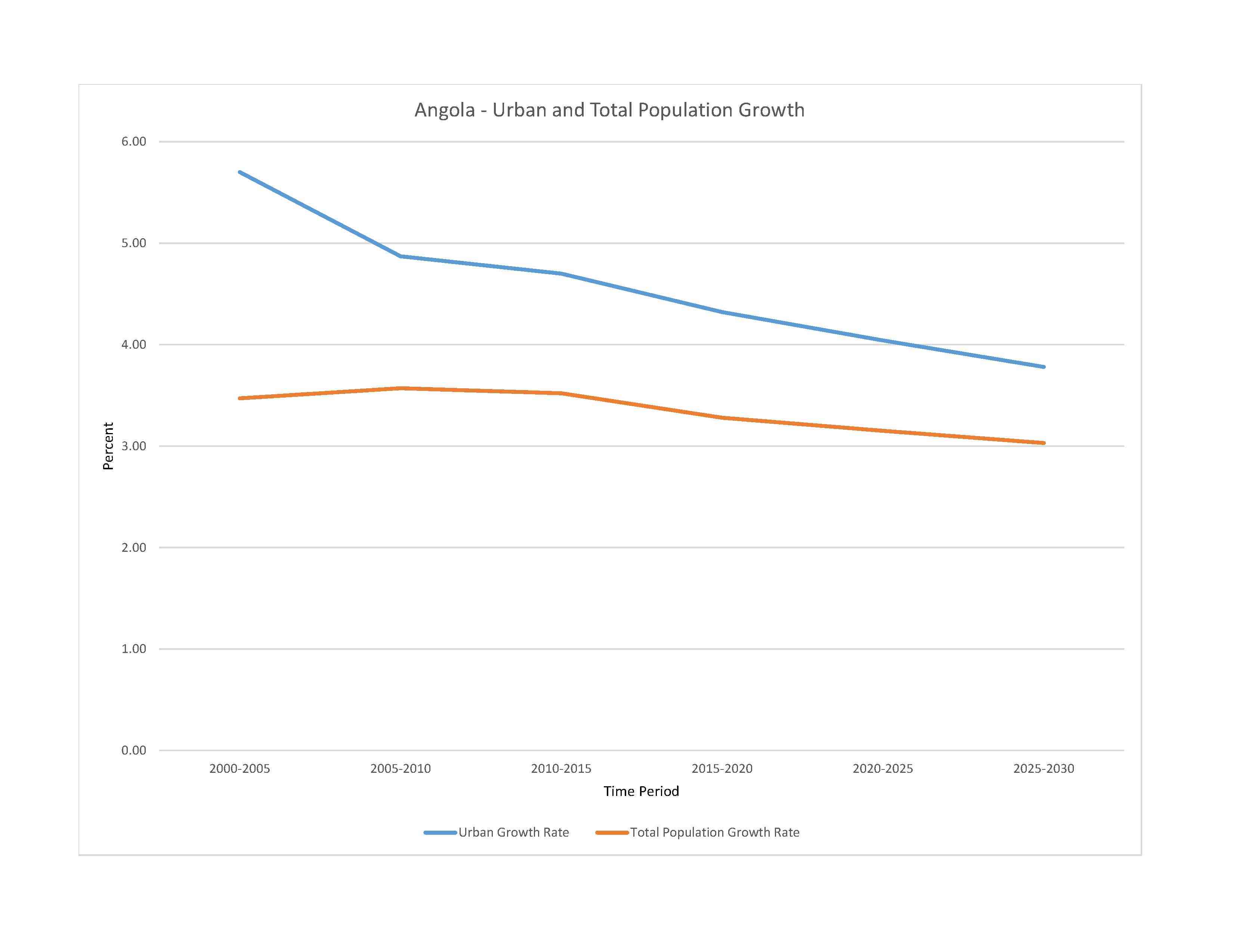
urban population: 68.7% of total population (2023)
rate of urbanization: 4.04% annual rate of change (2020-25 est.)

0.36% of GDP (2018 est.)
0% of GDP (2018 est.)
particulate matter emissions: 27.16 micrograms per cubic meter (2019 est.)
carbon dioxide emissions: 34.69 megatons (2016 est.)
methane emissions: 23.28 megatons (2020 est.)
municipal solid waste generated annually: 4,213,644 tons (2012 est.)
Rio Zambeze (Zambezi) (shared with Zambia [s], Namibia, Botswana, Zimbabwe, and Mozambique [m]) - 2,740 km; Rio Cubango (Okavango) river source (shared with Namibia and Botswana [m]) - 1,600 km
note – [s] after country name indicates river source; [m] after country name indicates river mouth
Atlantic Ocean drainage: Congo (3,730,881 sq km)
Indian Ocean drainage: Zambezi (1,332,412 sq km)
Internal (endorheic basin) drainage: Okavango Basin (863,866 sq km)
Congo Basin, Upper Kalahari-Cuvelai-Upper Zambezi Basin
municipal: 320 million cubic meters (2020 est.)
industrial: 240 million cubic meters (2020 est.)
agricultural: 150 million cubic meters (2020 est.)
148.4 billion cubic meters (2020 est.)
NOTE: The information regarding Angola on this page is re-published from the 2024 World Fact Book of the United States Central Intelligence Agency and other sources. No claims are made regarding the accuracy of Angola 2024 information contained here. All suggestions for corrections of any errors about Angola 2024 should be addressed to the CIA or the source cited on each page.
This page was last modified 04 May 24, Copyright © 2024 ITA all rights reserved.