deforestation; industrial pollution of air, soil, and water; inadequate sanitation and water treatment contribute to disease; rapid depletion of the country's natural resources
party to: Biodiversity, Climate Change, Climate Change-Kyoto Protocol, Climate Change-Paris Agreement, Comprehensive Nuclear Test Ban, Desertification, Endangered Species, Hazardous Wastes, Law of the Sea, Nuclear Test Ban, Ozone Layer Protection, Ship Pollution, Tropical Timber 2006, Wetlands
signed, but not ratified: none of the selected agreements
tropical monsoon; cloudy, rainy, hot, humid summers (southwest monsoon, June to September); less cloudy, scant rainfall, mild temperatures, lower humidity during winter (northeast monsoon, December to April)
agricultural land: 19.2% (2018 est.)
arable land: 16.5% (2018 est.)
permanent crops: 2.2% (2018 est.)
permanent pasture: 0.5% (2018 est.)
forest: 48.2% (2018 est.)
other: 32.6% (2018 est.)
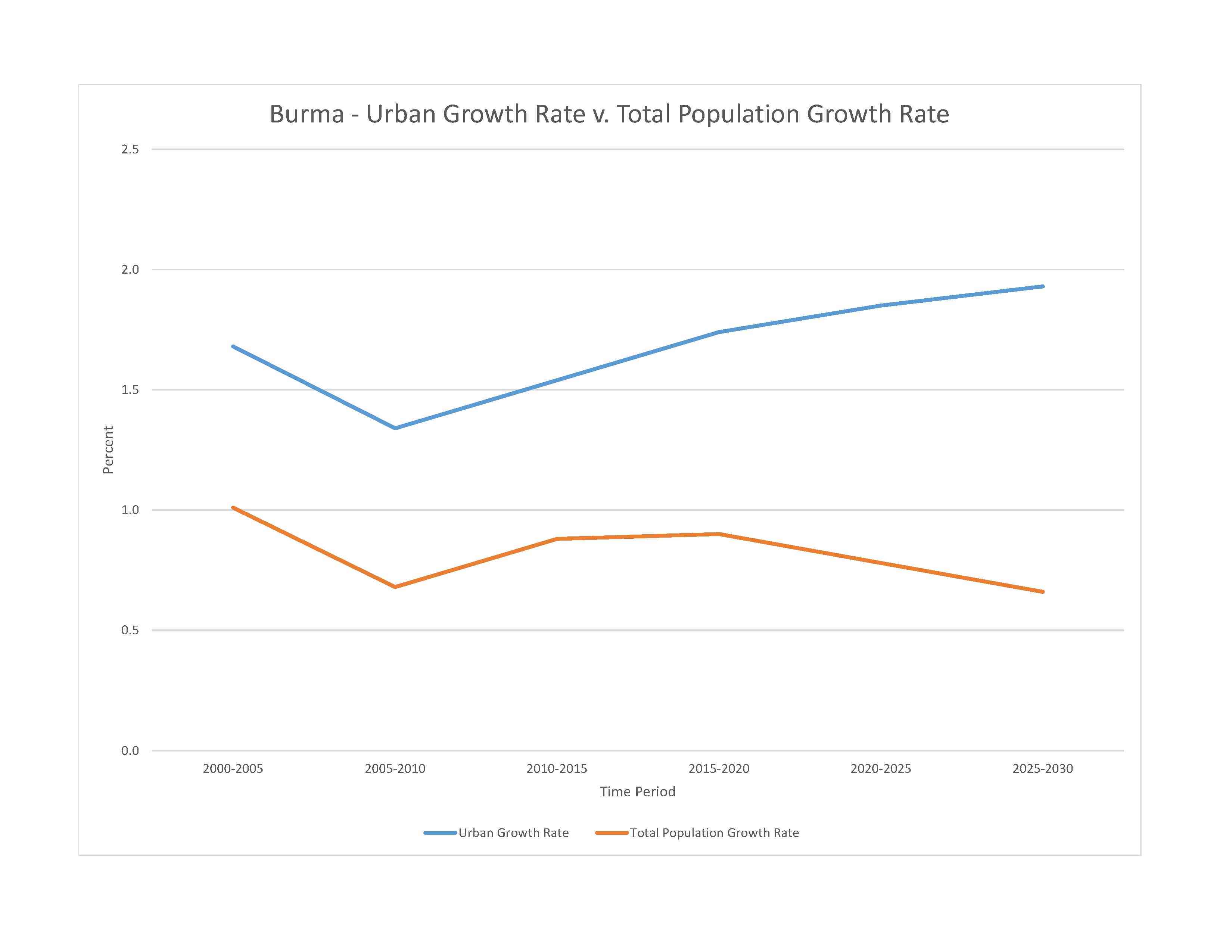
urban population: 32.1% of total population (2023)
rate of urbanization: 1.85% annual rate of change (2020-25 est.)

severe localized food insecurity:due to conflict, political instability, and economic constraints - the political crisis, following the military takeover on 1 February 2021, resulted in increased tensions and unrest throughout the country; the current uncertain political situation may further compromise the fragile situation of vulnerable households and the Rohingya IDPs residing in the country; armed conflict between the military and non‑state armed groups led to population displacements, disrupted agricultural activities and limited access for humanitarian support especially in Rakhine, Chin, Kachin, Kayin, Kayah and Shan states; income losses and a decline in remittances, due to the impact of the COVID‑19 pandemic, have affected the food security situation of vulnerable households; domestic prices of Emata rice, the most consumed variety in the country, were at high levels in May 2022, constraining access to a key staple food (2022)
1.69% of GDP (2018 est.)
0.01% of GDP (2018 est.)
particulate matter emissions: 27.16 micrograms per cubic meter (2019 est.)
carbon dioxide emissions: 25.28 megatons (2016 est.)
methane emissions: 42.2 megatons (2020 est.)
municipal solid waste generated annually: 4,677,307 tons (2000 est.)
Mekong (shared with China [s], Laos, Thailand, Cambodia, and Vietnam [m]) - 4,350 km; Salween river mouth (shared with China [s] and Thailand) - 3,060 km; Irrawaddy river mouth (shared with China [s]) - 2,809 km; Chindwin - 1,158 km
note – [s] after country name indicates river source; [m] after country name indicates river mouth
Indian Ocean drainage: Brahmaputra (651,335 sq km), Ganges (1,016,124 sq km), Irrawaddy (413,710 sq km), Salween (271,914 sq km)
Pacific Ocean drainage: Mekong (805,604 sq km)
municipal: 3.32 billion cubic meters (2019 est.)
industrial: 500 million cubic meters (2019 est.)
agricultural: 29.57 billion cubic meters (2019 est.)
1.2 trillion cubic meters (2020 est.)
NOTE: The information regarding Burma on this page is re-published from the 2024 World Fact Book of the United States Central Intelligence Agency and other sources. No claims are made regarding the accuracy of Burma 2024 information contained here. All suggestions for corrections of any errors about Burma 2024 should be addressed to the CIA or the source cited on each page.
This page was last modified 04 May 24, Copyright © 2024 ITA all rights reserved.