metal smelting, coal-burning utilities, and vehicle emissions impacting agricultural and forest productivity; air pollution and resulting acid rain severely affecting lakes and damaging forests; ocean waters becoming contaminated due to agricultural, industrial, mining, and forestry activities
party to: Air Pollution, Air Pollution-Heavy Metals, Air Pollution-Multi-effect Protocol, Air Pollution-Nitrogen Oxides, Air Pollution-Persistent Organic Pollutants, Air Pollution-Sulphur 85, Air Pollution-Sulphur 94, Antarctic-Environmental Protection, Antarctic-Marine Living Resources, Antarctic Treaty, Biodiversity, Climate Change, Climate Change-Paris Agreement, Comprehensive Nuclear Test Ban, Desertification, Endangered Species, Environmental Modification, Hazardous Wastes, Law of the Sea, Marine Dumping-London Convention, Marine Dumping-London Protocol, Nuclear Test Ban, Ozone Layer Protection, Ship Pollution, Wetlands
signed, but not ratified: Air Pollution-Volatile Organic Compounds, Marine Life Conservation
varies from temperate in south to subarctic and arctic in north
agricultural land: 6.8% (2018 est.)
arable land: 4.7% (2018 est.)
permanent crops: 0.5% (2018 est.)
permanent pasture: 1.6% (2018 est.)
forest: 34.1% (2018 est.)
other: 59.1% (2018 est.)
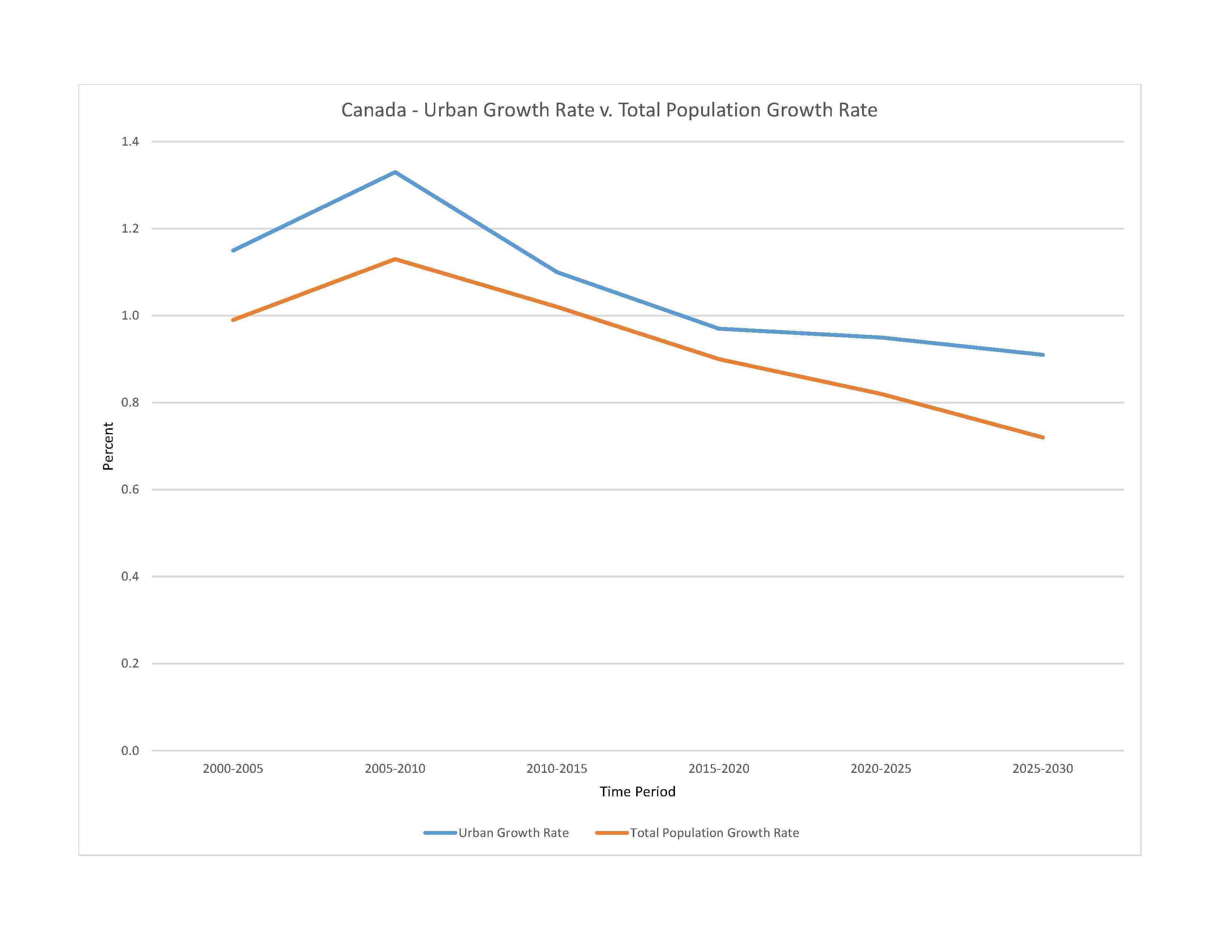
urban population: 81.9% of total population (2023)
rate of urbanization: 0.95% annual rate of change (2020-25 est.)

0.08% of GDP (2018 est.)
0.08% of GDP (2018 est.)
particulate matter emissions: 6.39 micrograms per cubic meter (2019 est.)
carbon dioxide emissions: 544.89 megatons (2016 est.)
methane emissions: 101.82 megatons (2020 est.)
municipal solid waste generated annually: 25,103,034 tons (2014 est.)
municipal solid waste recycled annually: 5,168,715 tons (2008 est.)
percent of municipal solid waste recycled: 20.6% (2008 est.)
fresh water lake(s): Huron* - 35,972 sq km; Great Bear Lake - 31,328 sq km; Superior* - 28,754 sq km; Great Slave Lake - 28,568 sq km; Lake Winnipeg - 24,387 sq km; Erie* - 12,776 sq km; Ontario* - 9,790 sq km; Lake Athabasca - 7,935 sq km; Reindeer Lake - 6,650 sq km; Nettilling Lake - 5,542 sq km
note - Great Lakes* area shown as Canadian waters
Mackenzie - 4, 241 km; Yukon river source (shared with the US [m]) - 3,185 km; Saint Lawrence river mouth (shared with US) - 3,058 km; Nelson - 2,570 km; Columbia river source (shared with the US [m]) - 1,953 km; Churchill - 1,600 km; Fraser - 1,368 km; Ottawa - 1,271 km; Athabasca - 1,231 km; North Saskatchewan - 1,220 km; Liard - 1,115 km
note – [s] after country name indicates river source; [m] after country name indicates river mouth
Atlantic Ocean drainage: Mississippi* (Gulf of Mexico) (3,202,185 sq km, Canada only 32,000 sq km), Nelson (Hudson Bay) (1,093,141 sq km), Saint Lawrence* (1,049,636 sq km, Canada only 839,200 sq km)
Arctic Ocean drainage: Mackenzie (1,706,388 sq km)
Pacific Ocean drainage: Yukon* (847,620 sq km, Canada only 823,800 sq km), Columbia* (657,501 sq km, Canada only 103,000 sq km)
note - watersheds shared with the US shown with *
Northern Great Plains Aquifer
municipal: 4.87 billion cubic meters (2020 est.)
industrial: 27.51 billion cubic meters (2020 est.)
agricultural: 3.86 billion cubic meters (2020 est.)
2.9 trillion cubic meters (2020 est.)
total global geoparks and regional networks: 5
global geoparks and regional networks: Perce; Stonehammer; Tumbler Ridge; Cliffs of Fundy; Discovery (2023)
NOTE: The information regarding Canada on this page is re-published from the 2024 World Fact Book of the United States Central Intelligence Agency and other sources. No claims are made regarding the accuracy of Canada 2024 information contained here. All suggestions for corrections of any errors about Canada 2024 should be addressed to the CIA or the source cited on each page.
This page was last modified 04 May 24, Copyright © 2024 ITA all rights reserved.