Northern Africa, bordering the Mediterranean Sea, between Libya and the Gaza Strip, and the Red Sea north of Sudan, and includes the Asian Sinai Peninsula
27 00 N, 30 00 E
Africa
total: 1,001,450 sq km
land: 995,450 sq km
water: 6,000 sq km
more than eight times the size of Ohio; slightly more than three times the size of New Mexico
total: 2,612 km
border countries (4): Gaza Strip 13 km; Israel 208 km; Libya 1,115 km; Sudan 1,276 km
2,450 km
territorial sea: 12 nm
contiguous zone: 24 nm
exclusive economic zone: 200 nm or the equidistant median line with Cyprus
continental shelf: 200 nm
desert; hot, dry summers with moderate winters
vast desert plateau interrupted by Nile valley and delta
highest point: Mount Catherine 2,629 m
lowest point: Qattara Depression -133 m
mean elevation: 321 m
petroleum, natural gas, iron ore, phosphates, manganese, limestone, gypsum, talc, asbestos, lead, rare earth elements, zinc
agricultural land: 3.6% (2018 est.)
arable land: 2.8% (2018 est.)
permanent crops: 0.8% (2018 est.)
permanent pasture: 0% (2018 est.)
forest: 0.1% (2018 est.)
other: 96.3% (2018 est.)
36,500 sq km (2012)
salt water lake(s): Lake Manzala - 1,360 sq km
note - largest of Nile Delta lakes
An Nīl (Nile) river mouth (shared with Rwanda [s], Tanzania, Uganda, South Sudan, and Sudan) - 6,650 km
note – [s] after country name indicates river source; [m] after country name indicates river mouth
Atlantic Ocean drainage: (Mediterranean Sea) Nile (3,254,853 sq km)
Nubian Aquifer System
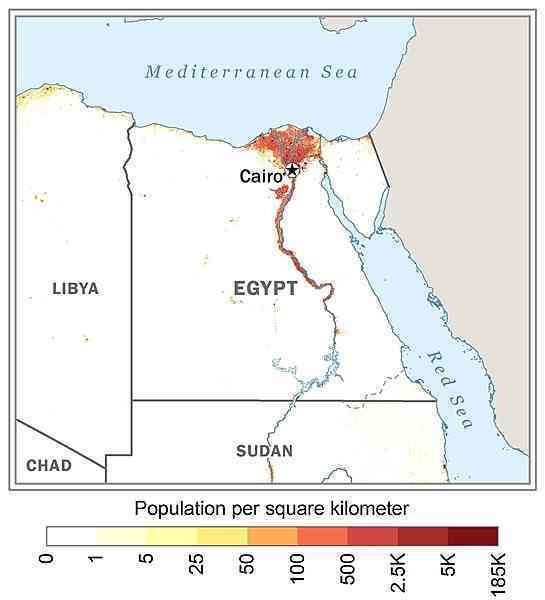
approximately 95% of the population lives within 20 km of the Nile River and its delta; vast areas of the country remain sparsely populated or uninhabited as shown in this 
periodic droughts; frequent earthquakes; flash floods; landslides; hot, driving windstorms called khamsin occur in spring; dust storms; sandstorms
note: controls Sinai Peninsula, the only land bridge between Africa and remainder of Eastern Hemisphere; controls Suez Canal, a sea link between Indian Ocean and Mediterranean Sea; size, and juxtaposition to Israel, establish its major role in Middle Eastern geopolitics; dependence on upstream neighbors; dominance of Nile basin issues; prone to influxes of refugees from Sudan and the Palestinian territories
NOTE: The information regarding Egypt on this page is re-published from the 2024 World Fact Book of the United States Central Intelligence Agency and other sources. No claims are made regarding the accuracy of Egypt 2024 information contained here. All suggestions for corrections of any errors about Egypt 2024 should be addressed to the CIA or the source cited on each page.
This page was last modified 04 May 24, Copyright © 2024 ITA all rights reserved.