deforestation; overgrazing; soil erosion; desertification; loss of biodiversity; water shortages in some areas from water-intensive farming and poor management; industrial pollution and pesticides contribute to air, water, and soil pollution
party to: Biodiversity, Climate Change, Climate Change-Kyoto Protocol, Climate Change-Paris Agreement, Comprehensive Nuclear Test Ban, Desertification, Endangered Species, Hazardous Wastes, Ozone Layer Protection
signed, but not ratified: Environmental Modification, Law of the Sea, Nuclear Test Ban
tropical monsoon with wide topographic-induced variation
agricultural land: 36.3% (2018 est.)
arable land: 15.2% (2018 est.)
permanent crops: 1.1% (2018 est.)
permanent pasture: 20% (2018 est.)
forest: 12.2% (2018 est.)
other: 51.5% (2018 est.)
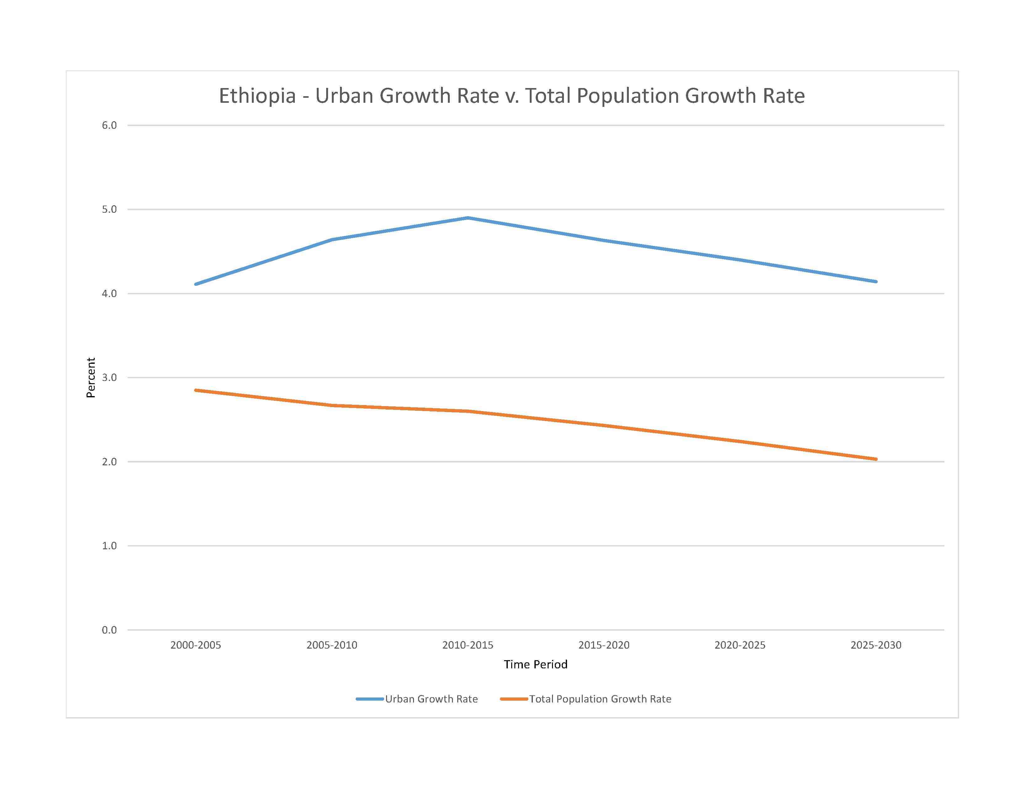
urban population: 23.2% of total population (2023)
rate of urbanization: 4.4% annual rate of change (2020-25 est.)

widespread lack of access:due to conflict in Tigray Region, drought conditions in southeastern areas, high food prices - The difficult and worsening food security situation is the result of multiple shocks affecting food availability and access including: the conflict in northern Tigray Region and in adjacent areas of Amhara and Afar regions, which began in November 2020; in Tigray region alone, 5.3 million people are estimated to be severely food insecure; the failure of the March‑May 2022 “Gu‑Genna” rains in southern pastoral areas of southern Oromiya Region and southern Somali Region, exacerbated drought conditions prevailing since late 2020, causing severe crop and livestock losses; severe macroeconomic challenges including insufficient foreign currency reserves and the continuous depreciation of the national currency, as a result, inflation is at very high levels, with the year‑on‑year food inflation rate estimated at 35.5 percent in July, one the highest of the last decade; these difficulties are exacerbated by the ripple effects of the Ukraine war, which triggered hikes in international prices of wheat, fuel, and fertilizers (2023)
5.81% of GDP (2018 est.)
0% of GDP (2018 est.)
particulate matter emissions: 21.8 micrograms per cubic meter (2019 est.)
carbon dioxide emissions: 14.87 megatons (2016 est.)
methane emissions: 114.21 megatons (2020 est.)
municipal solid waste generated annually: 6,532,787 tons (2015 est.)
fresh water lake(s): Lake Tana - 3,600 sq km; Abaya Hayk - 1,160 sq km; Ch'amo Hayk - 550 sq km
salt water lake(s): Lake Turkana (shared with Kenya) - 6,400 sq km; Abhe Bid Hayk/Abhe Bad (shared with Djibouti) - 780 sq km;
Blue Nile river source (shared with Sudan [m]) - 1,600 km
note – [s] after country name indicates river source; [m] after country name indicates river mouth
Atlantic Ocean drainage: (Mediterranean Sea) Nile (3,254,853 sq km)
Ogaden-Juba Basin, Sudd Basin (Umm Ruwaba Aquifer)
municipal: 810 million cubic meters (2020 est.)
industrial: 50 million cubic meters (2020 est.)
agricultural: 9.69 billion cubic meters (2020 est.)
122 billion cubic meters (2020 est.)
NOTE: The information regarding Ethiopia on this page is re-published from the 2024 World Fact Book of the United States Central Intelligence Agency and other sources. No claims are made regarding the accuracy of Ethiopia 2024 information contained here. All suggestions for corrections of any errors about Ethiopia 2024 should be addressed to the CIA or the source cited on each page.
This page was last modified 04 May 24, Copyright © 2024 ITA all rights reserved.