radioactive or toxic chemical sites associated with former defense industries and test ranges scattered throughout the country pose health risks for humans and animals; industrial pollution is severe in some cities; because the two main rivers that flowed into the Aral Sea have been diverted for irrigation, it is drying up and leaving behind a harmful layer of chemical pesticides and natural salts; these substances are then picked up by the wind and blown into noxious dust storms; pollution in the Caspian Sea; desertification; soil pollution from overuse of agricultural chemicals and salination from poor infrastructure and wasteful irrigation practices
party to: Air Pollution, Antarctic Treaty, Biodiversity, Climate Change, Climate Change-Kyoto Protocol, Climate Change-Paris Agreement, Comprehensive Nuclear Test Ban, Desertification, Endangered Species, Environmental Modification, Hazardous Wastes, Ozone Layer Protection, Ship Pollution, Wetlands
signed, but not ratified: none of the selected agreements
continental, cold winters and hot summers, arid and semiarid
agricultural land: 77.4% (2018 est.)
arable land: 8.9% (2018 est.)
permanent crops: 0% (2018 est.)
permanent pasture: 68.5% (2018 est.)
forest: 1.2% (2018 est.)
other: 21.4% (2018 est.)
urban population: 58.2% of total population (2023)
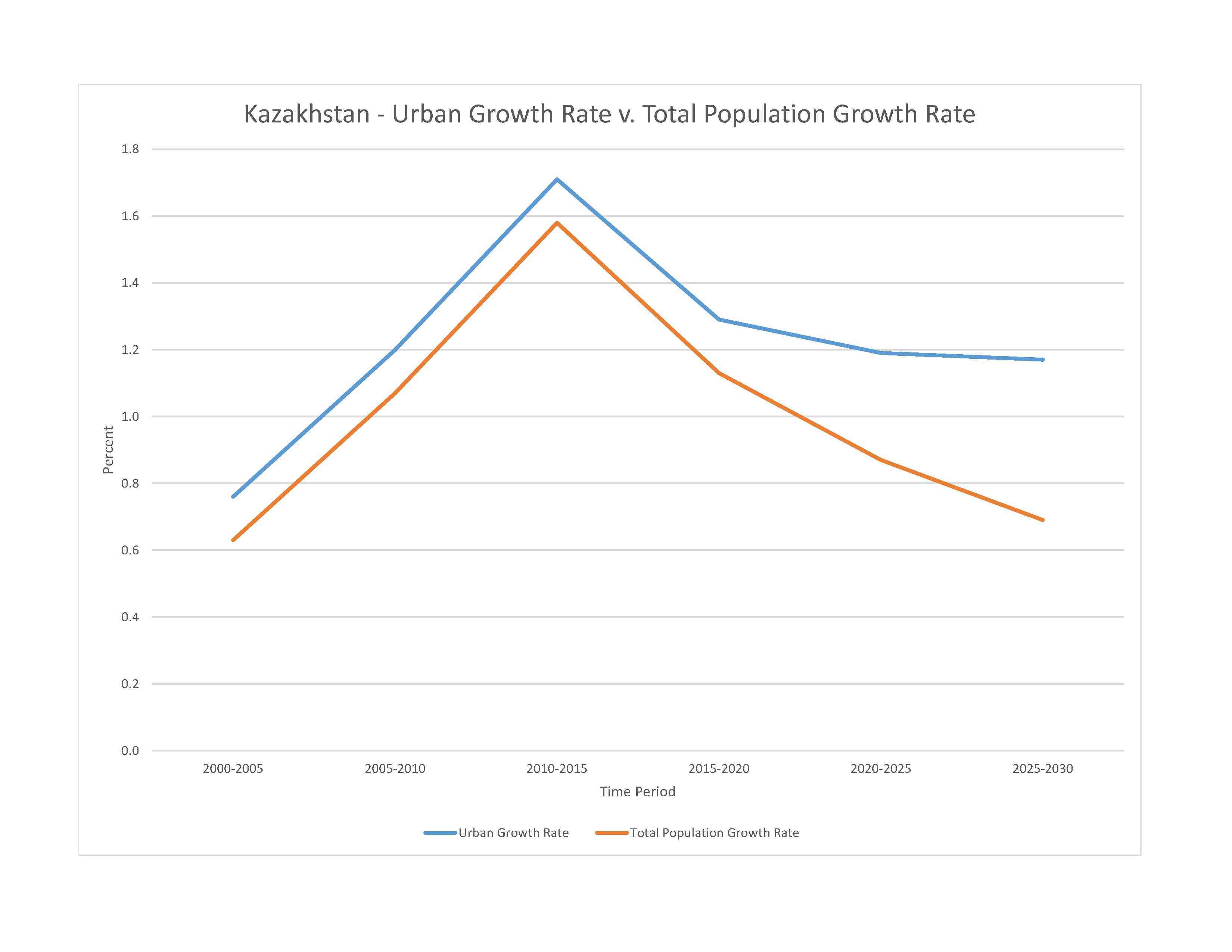
rate of urbanization: 1.19% annual rate of change (2020-25 est.)

0% of GDP (2018 est.)
0.99% of GDP (2018 est.)
particulate matter emissions: 26.5 micrograms per cubic meter (2019 est.)
carbon dioxide emissions: 247.21 megatons (2016 est.)
methane emissions: 45.03 megatons (2020 est.)
municipal solid waste generated annually: 4,659,740 tons (2012 est.)
municipal solid waste recycled annually: 136,064 tons (2012 est.)
percent of municipal solid waste recycled: 2.9% (2012 est.)
fresh water lake(s): Ozero Balkhash - 22,000 sq km; Ozero Zaysan - 1,800 sq km
salt water lake(s): Caspian Sea (shared with Iran, Azerbaijan, Turkmenistan, and Russia) - 374,000 sq km; Aral Sea (north) - 3,300 sq km; Ozero Alakol - 2,650 sq km; Ozero Teniz 1,590 sq km; Ozero Seletytenzi - 780 sq km; Ozero Sasykkol - 740 sq km
Syr Darya river mouth (shared with Kyrgyzstan [s], Uzbekistan, and Tajikistan) - 3,078 km
note – [s] after country name indicates river source; [m] after country name indicates river mouth
Internal (endorheic basin) drainage: Tarim Basin (1,152,448 sq km), Amu Darya (534,739 sq km), Syr Darya (782,617 sq km), Lake Balkash (510,015 sq km)
municipal: 4.62 billion cubic meters (2020 est.)
industrial: 4.54 billion cubic meters (2020 est.)
agricultural: 15.4 billion cubic meters (2020 est.)
108.41 billion cubic meters (2020 est.)
NOTE: The information regarding Kazakhstan on this page is re-published from the 2024 World Fact Book of the United States Central Intelligence Agency and other sources. No claims are made regarding the accuracy of Kazakhstan 2024 information contained here. All suggestions for corrections of any errors about Kazakhstan 2024 should be addressed to the CIA or the source cited on each page.
This page was last modified 04 May 24, Copyright © 2024 ITA all rights reserved.