
deforestation; soil erosion; desertification; loss of pasture land; inadequate supplies of potable water
party to: Biodiversity, Climate Change, Climate Change-Kyoto Protocol, Climate Change-Paris Agreement, Comprehensive Nuclear Test Ban, Desertification, Endangered Species, Hazardous Wastes, Law of the Sea, Ozone Layer Protection, Tropical Timber 2006, Wetlands, Whaling
signed, but not ratified: Nuclear Test Ban
subtropical to arid; hot and dry (February to June); rainy, humid, and mild (June to November); cool and dry (November to February)
agricultural land: 34.1% (2018 est.)
arable land: 5.6% (2018 est.)
permanent crops: 0.1% (2018 est.)
permanent pasture: 28.4% (2018 est.)
forest: 10.2% (2018 est.)
other: 55.7% (2018 est.)
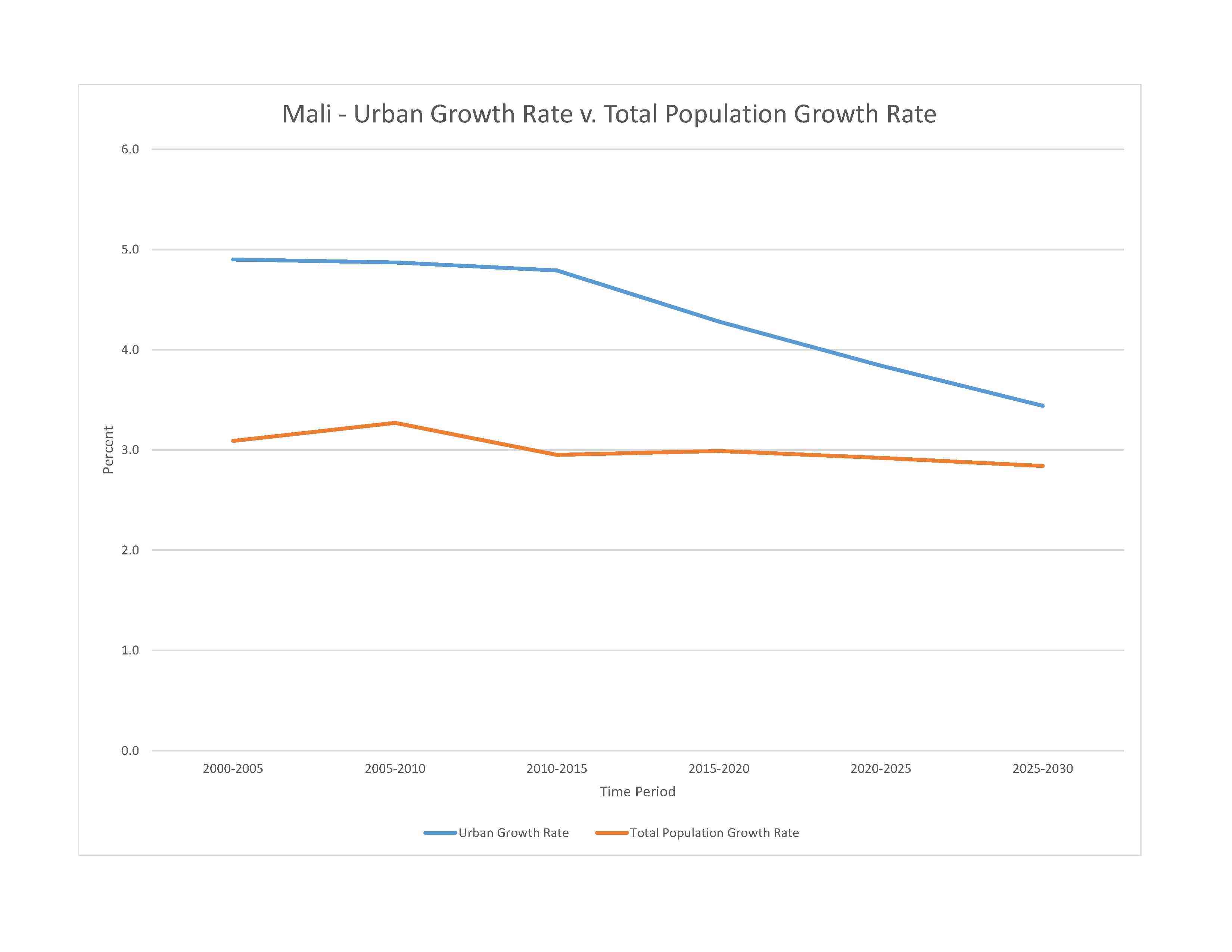
urban population: 46.2% of total population (2023)
rate of urbanization: 4.57% annual rate of change (2020-25 est.)
severe localized food insecurity:
due to civil insecurity and high food prices - according to the latest analysis, about 1.26 million people are projected to face acute food insecurity during the June to August 2023 lean season period; in total however, the number of food insecure is lower in 2023 compared to 2022; food insecurity conditions are primarily underpinned by the impact of the conflict in central and northern areas, which has caused the displacement of over 375,000 people, as of April 2023; persistent high food prices affect vulnerable households across the country, but limit in particular the food access of people in conflict-affected areas due to market disruptions and limited access to sources of income and humanitarian assistance
(2023)
2.02% of GDP (2018 est.)
0% of GDP (2018 est.)
particulate matter emissions: 38.55 micrograms per cubic meter (2019 est.)
carbon dioxide emissions: 3.18 megatons (2016 est.)
methane emissions: 19.16 megatons (2020 est.)
municipal solid waste generated annually: 1,937,354 tons (2012 est.)
fresh water lake(s): Lac Faguibine - 590 sq km
note - the Niger River is the only source of water for the lake; in recent years the lake is dry
Niger (shared with Guinea [s], Niger, and Nigeria [m]) - 4,200 km; Senegal (shared with Guinea [s], Senegal, and Mauritania [m]) - 1,641 km
note – [s] after country name indicates river source; [m] after country name indicates river mouth
Atlantic Ocean drainage: Niger (2,261,741 sq km), Senegal (456,397 sq km), Volta (410,991 sq km)
Lullemeden-Irhazer Basin, Taodeni-Tanezrouft Basin
municipal: 110 million cubic meters (2020 est.)
industrial: 4 million cubic meters (2020 est.)
agricultural: 5.08 billion cubic meters (2020 est.)
120 billion cubic meters (2020 est.)
NOTE: The information regarding Mali on this page is re-published from the 2024 World Fact Book of the United States Central Intelligence Agency and other sources. No claims are made regarding the accuracy of Mali 2024 information contained here. All suggestions for corrections of any errors about Mali 2024 should be addressed to the CIA or the source cited on each page.


This page was last modified 04 May 24, Copyright © 2024 ITA all rights reserved.


