


Location:
Central Africa, south of Libya
Geographic coordinates:
15 00 N, 19 00 E
Map references:
Africa
Area:
total: 1.284 million sq km
[see also: Area - total country ranks ]
land: 1,259,200 sq km
[see also: Area - land country ranks ]
water: 24,800 sq km
[see also: Area - water country ranks ]
country comparison to the world (CIA rank, may be based on non-current data):
22
Area - comparative:
almost nine times the size of New York state; slightly more than three times the size of California
Area comparison map:
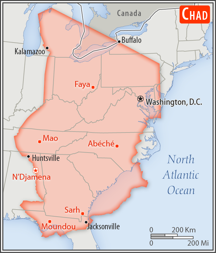
almost nine times the size of New York state; slightly more than three times the size of California
Land boundaries:
total: 6,406 km
[see also: Land boundaries - total country ranks ]
border countries (6):
Cameroon 1116 km, Central African Republic 1556 km, Libya 1050 km, Niger 1196 km, Nigeria 85 km, Sudan 1403 km
Coastline:
0 km
(landlocked)
[see also: Coastline country ranks ]
Maritime claims:
none (landlocked)
Climate:
tropical in south, desert in north
More Climate Details
Terrain:
broad, arid plains in center, desert in north, mountains in northwest, lowlands in south
Elevation:
mean elevation: 543 m
[see also: Elevation - mean elevation country ranks ]
lowest point:
Djourab 160 m
highest point:
Emi Koussi 3,445 m
Natural resources:
petroleum, uranium, natron, kaolin, fish (Lake Chad), gold, limestone, sand and gravel, salt
Land use:
agricultural land: 39.6%
(2011 est.)
[see also: Land use - agricultural land country ranks ]
arable land: 3.9%
(2011 est.)
[see also: Land use - arable land country ranks ]
permanent crops: 0%
(2011 est.)
[see also: Land use - permanent crops country ranks ]
permanent pasture: 35.7%
(2011 est.)
[see also: Land use - permanent pasture country ranks ]
forest: 9.1%
(2011 est.)
[see also: Land use - forest country ranks ]
other: 51.3%
(2011 est.)
[see also: Land use country ranks ]
Irrigated land:
300 sq km
(2012)
[see also: Irrigated land country ranks ]
Population distribution:
the population is unevenly distributed due to contrasts in climate and physical geography; the highest density is found in the southwest, particularly around Lake Chad and points south; the dry Saharan zone to the north is the least densely populated
Natural hazards:
hot, dry, dusty harmattan winds occur in north; periodic droughts; locust plagues
Environment - current issues:
inadequate supplies of potable water; improper waste disposal in rural areas and poor farming practices contribute to soil and water pollution; desertification
Environment - international agreements:
party to:
Biodiversity, Climate Change, Desertification, Endangered Species, Hazardous Wastes, Ozone Layer Protection, Wetlands
signed, but not ratified:
Law of the Sea, Marine Dumping
note 1: Chad is the largest of Africa's 16 landlocked countries
note 2: not long ago - geologically speaking - what is today the Sahara was green savannah teeming with wildlife; during the African Humid Period, roughly 11,000 to 5,000 years ago, a vibrant animal community, including elephants, giraffes, hippos, and antelope lived there; the last remnant of the "Green Sahara" exists in the Lakes of Ounianga (oo-nee-ahn-ga) in northern Chad, a series of 18 interconnected freshwater, saline, and hypersaline lakes now protected as a World Heritage site
note 3: Lake Chad, the most significant water body in the Sahel, is a remnant of a former inland sea, paleolake Mega-Chad; at its greatest extent, sometime before 5000 B.C., Lake Mega-Chad was the largest of four Saharan paleolakes that existed during the African Humid Period; it covered an area of about 400,000 sq km (150,000 sq mi), roughly the size of today's Caspian Sea
NOTE: 1) The information regarding Chad on this page is re-published from the 2020 World Fact Book of the United States Central Intelligence Agency and other sources. No claims are made regarding the accuracy of Chad Geography 2020 information contained here. All suggestions for corrections of any errors about Chad Geography 2020 should be addressed to the CIA or the source cited on each page.
2) The rank that you see is the CIA reported rank, which may have the following issues:
a) They assign increasing rank number, alphabetically for countries with the same value of the ranked item, whereas we assign them the same rank.
b) The CIA sometimes assigns counterintuitive ranks. For example, it assigns unemployment rates in increasing order, whereas we rank them in decreasing order.
- Main Index
- 2020 Index
- Country Ranks
- Definitions
- Chad Index 2020
- Chad Main Index
- Introduction
- History
- Geography
- Climate
- Maps
- People
- Religion
- Government
- Gov. Leaders
- Flags
- Economy
- Energy
- Communications
- Transportation
- Airport Codes
- Military
- Terrorism
- Transnational Issues
- Photos
- Advertise Here
- Feedback

This page was last modified 27-Jan-20