


Location:
Eastern Africa, west of Somalia
Geographic coordinates:
8 00 N, 38 00 E
Map references:
Africa
Area:
total: 1,104,300 sq km
[see also: Area - total country ranks ]
land: 1,096,570 sq km
[see also: Area - land country ranks ]
water: 7,730 sq km
note: area numbers are approximate since a large portion of the Ethiopia-Somalia border is undefined
country comparison to the world (CIA rank, may be based on non-current data):
28
Area - comparative:
slightly less than twice the size of Texas
Area comparison map:
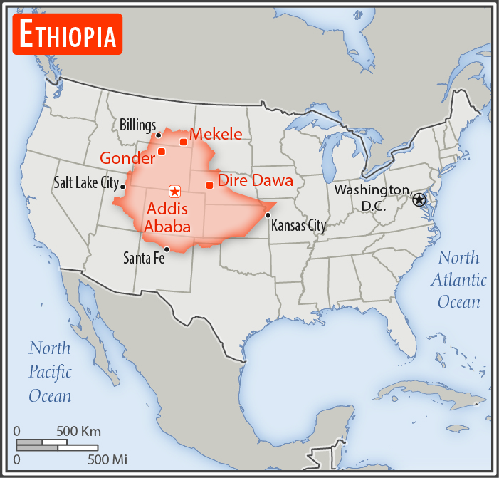
slightly less than twice the size of Texas
Land boundaries:
total: 5,925 km
[see also: Land boundaries - total country ranks ]
border countries (6):
Djibouti 342 km, Eritrea 1033 km, Kenya 867 km, Somalia 1640 km, South Sudan 1299 km, Sudan 744 km
Coastline:
0 km
(landlocked)
[see also: Coastline country ranks ]
Maritime claims:
none (landlocked)
Climate:
tropical monsoon with wide topographic-induced variation
More Climate Details
Terrain:
high plateau with central mountain range divided by Great Rift Valley
Elevation:
mean elevation: 1,330 m
[see also: Elevation - mean elevation country ranks ]
lowest point:
Danakil Depression -125 m
highest point:
Ras Dejen 4,550 m
Natural resources:
small reserves of gold, platinum, copper, potash, natural gas, hydropower
Land use:
agricultural land: 36.3%
(2011 est.)
[see also: Land use - agricultural land country ranks ]
arable land: 15.2%
(2011 est.)
[see also: Land use - arable land country ranks ]
permanent crops: 1.1%
(2011 est.)
[see also: Land use - permanent crops country ranks ]
permanent pasture: 20%
(2011 est.)
[see also: Land use - permanent pasture country ranks ]
forest: 12.2%
(2011 est.)
[see also: Land use - forest country ranks ]
other: 51.5%
(2011 est.)
[see also: Land use country ranks ]
Irrigated land:
2,900 sq km
(2012)
[see also: Irrigated land country ranks ]
Population distribution:
highest density is found in the highlands of the north and middle areas of the country, particularly around the centrally located capital city of Addis Ababa; the far east and southeast are sparsely populated
Natural hazards:
geologically active Great Rift Valley susceptible to earthquakes, volcanic eruptions; frequent droughts
volcanism: volcanic activity in the Great Rift Valley; Erta Ale (613 m), which has caused frequent lava flows in recent years, is the country's most active volcano; Dabbahu became active in 2005, forcing evacuations; other historically active volcanoes include Alayta, Dalaffilla, Dallol, Dama Ali, Fentale, Kone, Manda Hararo, and Manda-Inakir
Environment - current issues:
deforestation; overgrazing; soil erosion; desertification; loss of biodiversity; water shortages in some areas from water-intensive farming and poor management; industrial pollution and pesticides contribute to air, water, and soil pollution
Environment - international agreements:
party to:
Biodiversity, Climate Change, Climate Change-Kyoto Protocol, Desertification, Endangered Species, Hazardous Wastes, Ozone Layer Protection
signed, but not ratified:
Environmental Modification, Law of the Sea
Geography - note:
note 1: landlocked - entire coastline along the Red Sea was lost with the de jure independence of Eritrea on 24 May 1993; Ethiopia is, therefore, the most populous landlocked country in the world; the Blue Nile, the chief headstream of the Nile by water volume, rises in T'ana Hayk (Lake Tana) in northwest Ethiopia
note 2: three major crops are believed to have originated in Ethiopia: coffee, grain sorghum, and castor bean
NOTE: 1) The information regarding Ethiopia on this page is re-published from the 2020 World Fact Book of the United States Central Intelligence Agency and other sources. No claims are made regarding the accuracy of Ethiopia Geography 2020 information contained here. All suggestions for corrections of any errors about Ethiopia Geography 2020 should be addressed to the CIA or the source cited on each page.
2) The rank that you see is the CIA reported rank, which may have the following issues:
a) They assign increasing rank number, alphabetically for countries with the same value of the ranked item, whereas we assign them the same rank.
b) The CIA sometimes assigns counterintuitive ranks. For example, it assigns unemployment rates in increasing order, whereas we rank them in decreasing order.
- Main Index
- 2020 Index
- Country Ranks
- Definitions
- Ethiopia Index 2020
- Ethiopia Main Index
- Introduction
- History
- Geography
- Climate
- Maps
- People
- Religion
- Government
- Gov. Leaders
- Flags
- Economy
- Energy
- Communications
- Transportation
- Airport Codes
- Military
- Terrorism
- Transnational Issues
- Photos
- Advertise Here
- Feedback

This page was last modified 27-Jan-20