


Location:
Northern Africa, bordering the North Atlantic Ocean and the Mediterranean Sea, between Algeria and Western Sahara
Geographic coordinates:
32 00 N, 5 00 W
Map references:
Africa
Area:
total: 446,550 sq km
[see also: Area - total country ranks ]
land: 446,300 sq km
[see also: Area - land country ranks ]
water: 250 sq km
[see also: Area - water country ranks ]
country comparison to the world (CIA rank, may be based on non-current data):
59
Area - comparative:
slightly more than three times the size of New York; slightly larger than California
Area comparison map:
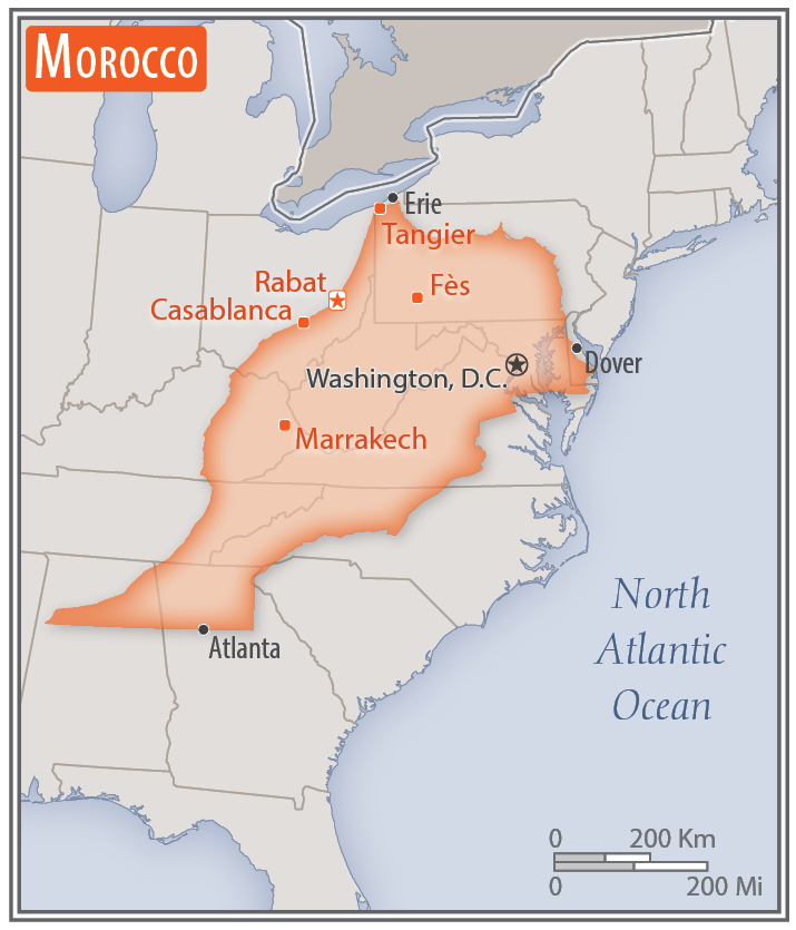
slightly more than three times the size of New York; slightly larger than California
Land boundaries:
total: 2,362.5 km
[see also: Land boundaries - total country ranks ]
border countries (4):
Algeria 1900 km, Western Sahara 444 km, Spain (Ceuta) 8 km, Spain (Melilla) 10.5 km
note: an additional 75-meter border segment exists between Morocco and the Spanish exclave of Penon de Velez de la Gomera
Coastline:
1,835 km
[see also: Coastline country ranks ]
Maritime claims:
territorial sea: 12
nm
[see also: Maritime claims - territorial sea country ranks ]
exclusive economic zone: 200
nm
[see also: Maritime claims - exclusive economic zone country ranks ]
contiguous zone: 24
nm
[see also: Maritime claims - contiguous zone country ranks ]
continental shelf:
200-m depth or to the depth of exploitation
[see also: Maritime claims - continental shelf country ranks ]
Climate:
Mediterranean, becoming more extreme in the interior
More Climate Details
Terrain:
mountainous northern coast (Rif Mountains) and interior (Atlas Mountains) bordered by large plateaus with intermontane valleys, and fertile coastal plains
Elevation:
mean elevation: 909 m
[see also: Elevation - mean elevation country ranks ]
lowest point:
Sebkha Tah -59 m
highest point:
Jebel Toubkal 4,165 m
Natural resources:
phosphates, iron ore, manganese, lead, zinc, fish, salt
Land use:
agricultural land: 67.5%
(2011 est.)
[see also: Land use - agricultural land country ranks ]
arable land: 17.5%
(2011 est.)
[see also: Land use - arable land country ranks ]
permanent crops: 2.9%
(2011 est.)
[see also: Land use - permanent crops country ranks ]
permanent pasture: 47.1%
(2011 est.)
[see also: Land use - permanent pasture country ranks ]
forest: 11.5%
(2011 est.)
[see also: Land use - forest country ranks ]
other: 21%
(2011 est.)
[see also: Land use country ranks ]
Irrigated land:
14,850 sq km
(2012)
[see also: Irrigated land country ranks ]
Population distribution:
the highest population density is found along the Atlantic and Mediterranean coasts; a number of densely populated agglomerations are found scattered through the Atlas Mountains
Natural hazards:
northern mountains geologically unstable and subject to earthquakes; periodic droughts; windstorms; flash floods; landslides
Environment - current issues:
land degradation/desertification (soil erosion resulting from farming of marginal areas, overgrazing, destruction of vegetation); water and soil pollution due to dumping of industrial wastes into the ocean and inland water sources, and onto the land
Environment - international agreements:
party to:
Biodiversity, Climate Change, Climate Change-Kyoto Protocol, Desertification, Endangered Species, Hazardous Wastes, Law of the Sea, Marine Dumping, Ozone Layer Protection, Ship Pollution, Wetlands, Whaling
signed, but not ratified:
Environmental Modification
Geography - note:
strategic location along Strait of Gibraltar; the only African nation to have both Atlantic and Mediterranean coastlines
NOTE: 1) The information regarding Morocco on this page is re-published from the 2020 World Fact Book of the United States Central Intelligence Agency and other sources. No claims are made regarding the accuracy of Morocco Geography 2020 information contained here. All suggestions for corrections of any errors about Morocco Geography 2020 should be addressed to the CIA or the source cited on each page.
2) The rank that you see is the CIA reported rank, which may have the following issues:
a) They assign increasing rank number, alphabetically for countries with the same value of the ranked item, whereas we assign them the same rank.
b) The CIA sometimes assigns counterintuitive ranks. For example, it assigns unemployment rates in increasing order, whereas we rank them in decreasing order.
- Main Index
- 2020 Index
- Country Ranks
- Definitions
- Morocco Index 2020
- Morocco Main Index
- Introduction
- History
- Geography
- Climate
- Maps
- People
- Religion
- Government
- Gov. Leaders
- Flags
- Economy
- Energy
- Communications
- Transportation
- Airport Codes
- Military
- Transnational Issues
- Photos
- Advertise Here
- Feedback

This page was last modified 27-Jan-20