


Location:
Western South America, bordering the South Pacific Ocean, between Chile and Ecuador
Geographic coordinates:
10 00 S, 76 00 W
Map references:
South America
Area:
total: 1,285,216 sq km
[see also: Area - total country ranks ]
land: 1,279,996 sq km
[see also: Area - land country ranks ]
water: 5,220 sq km
[see also: Area - water country ranks ]
country comparison to the world (CIA rank, may be based on non-current data):
21
Area - comparative:
almost twice the size of Texas; slightly smaller than Alaska
Area comparison map:
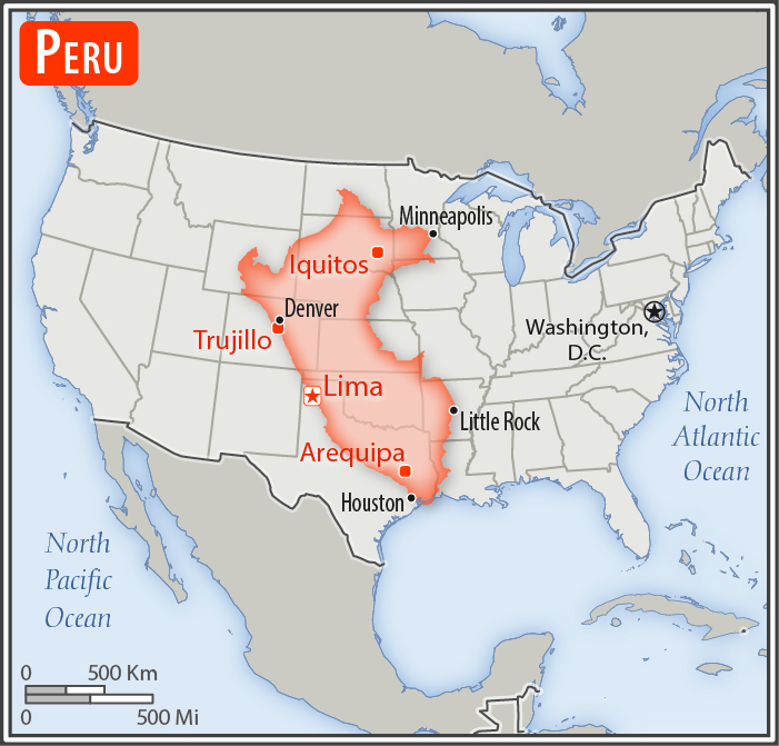
almost twice the size of Texas; slightly smaller than Alaska
Land boundaries:
total: 7,062 km
[see also: Land boundaries - total country ranks ]
border countries (5):
Bolivia 1212 km, Brazil 2659 km, Chile 168 km, Colombia 1494 km, Ecuador 1529 km
Coastline:
2,414 km
[see also: Coastline country ranks ]
Maritime claims:
territorial sea: 200
nm
[see also: Maritime claims - territorial sea country ranks ]
continental shelf: 200
nm
[see also: Maritime claims - continental shelf country ranks ]
Climate:
varies from tropical in east to dry desert in west; temperate to frigid in Andes
More Climate Details
Terrain:
western coastal plain (costa), high and rugged Andes in center (sierra), eastern lowland jungle of Amazon Basin (selva)
Elevation:
mean elevation: 1,555 m
[see also: Elevation - mean elevation country ranks ]
lowest point:
Pacific Ocean 0 m
highest point:
Nevado Huascaran 6,746 m
Natural resources:
copper, silver, gold, petroleum, timber, fish, iron ore, coal, phosphate, potash, hydropower, natural gas
Land use:
agricultural land: 18.8%
(2011 est.)
[see also: Land use - agricultural land country ranks ]
arable land: 3.1%
(2011 est.)
[see also: Land use - arable land country ranks ]
permanent crops: 1.1%
(2011 est.)
[see also: Land use - permanent crops country ranks ]
permanent pasture: 14.6%
(2011 est.)
[see also: Land use - permanent pasture country ranks ]
forest: 53%
(2011 est.)
[see also: Land use - forest country ranks ]
other: 28.2%
(2011 est.)
[see also: Land use country ranks ]
Irrigated land:
25,800 sq km
(2012)
[see also: Irrigated land country ranks ]
Population distribution:
approximately one-third of the population resides along the desert coastal belt in the west, with a strong focus on the capital city of Lima; the Andean highlands, or sierra, which is strongly identified with the country's Amerindian population, contains roughly half of the overall population; the eastern slopes of the Andes, and adjoining rainforest, are sparsely populated
Natural hazards:
earthquakes, tsunamis, flooding, landslides, mild volcanic activity
volcanism: volcanic activity in the Andes Mountains; Ubinas (5,672 m), which last erupted in 2009, is the country's most active volcano; other historically active volcanoes include El Misti, Huaynaputina, Sabancaya, and Yucamane; see note 2 under "Geography - note"
Environment - current issues:
deforestation (some the result of illegal logging); overgrazing of the slopes of the costa and sierra leading to soil erosion; desertification; air pollution in Lima; pollution of rivers and coastal waters from municipal and mining wastes; overfishing
Environment - international agreements:
party to:
Antarctic-Environmental Protocol, Antarctic-Marine Living Resources, Antarctic Treaty, Biodiversity, Climate Change, Climate Change-Kyoto Protocol, Desertification, Endangered Species, Hazardous Wastes, Marine Dumping, Ozone Layer Protection, Ship Pollution, Tropical Timber 83, Tropical Timber 94, Wetlands, Whaling
signed, but not ratified:
none of the selected agreements
note 1: shares control of Lago Titicaca, world's highest navigable lake, with Bolivia; a remote slope of Nevado Mismi, a 5,316 m peak, is the ultimate source of the Amazon River
note 2: Peru is one of the countries along the Ring of Fire, a belt of active volcanoes and earthquake epicenters bordering the Pacific Ocean; up to 90% of the world's earthquakes and some 75% of the world's volcanoes occur within the Ring of Fire
note 3: on 19 February 1600, Mount Huaynaputina in the southern Peruvian Andes erupted in the largest volcanic explosion in South America in historical times; intermittent eruptions lasted until 5 March 1600 and pumped an estimated 16 to 32 million metric tons of particulates into the atmosphere reducing the amount of sunlight reaching the earth's surface and affecting weather worldwide; over the next two and a half years, millions died around the globe in famines from bitterly cold winters, cool summers, and the loss of crops and animals
note 4: the southern regions of Peru and the extreme northwestern part of Bolivia are considered to be the place of origin for the common potato
NOTE: 1) The information regarding Peru on this page is re-published from the 2020 World Fact Book of the United States Central Intelligence Agency and other sources. No claims are made regarding the accuracy of Peru Geography 2020 information contained here. All suggestions for corrections of any errors about Peru Geography 2020 should be addressed to the CIA or the source cited on each page.
2) The rank that you see is the CIA reported rank, which may have the following issues:
a) They assign increasing rank number, alphabetically for countries with the same value of the ranked item, whereas we assign them the same rank.
b) The CIA sometimes assigns counterintuitive ranks. For example, it assigns unemployment rates in increasing order, whereas we rank them in decreasing order.
- Main Index
- 2020 Index
- Country Ranks
- Definitions
- Peru Index 2020
- Peru Main Index
- Introduction
- History
- Geography
- Climate
- Maps
- People
- Religion
- Government
- Gov. Leaders
- Flags
- Economy
- Energy
- Communications
- Transportation
- Airport Codes
- Military
- Terrorism
- Transnational Issues
- Photos
- Advertise Here
- Feedback

This page was last modified 27-Jan-20