


Location:
Northern Europe, bordering the Baltic Sea, Gulf of Bothnia, Kattegat, and Skagerrak, between Finland and Norway
Geographic coordinates:
62 00 N, 15 00 E
Map references:
Europe
Area:
total: 450,295 sq km
[see also: Area - total country ranks ]
land: 410,335 sq km
[see also: Area - land country ranks ]
water: 39,960 sq km
[see also: Area - water country ranks ]
country comparison to the world (CIA rank, may be based on non-current data):
57
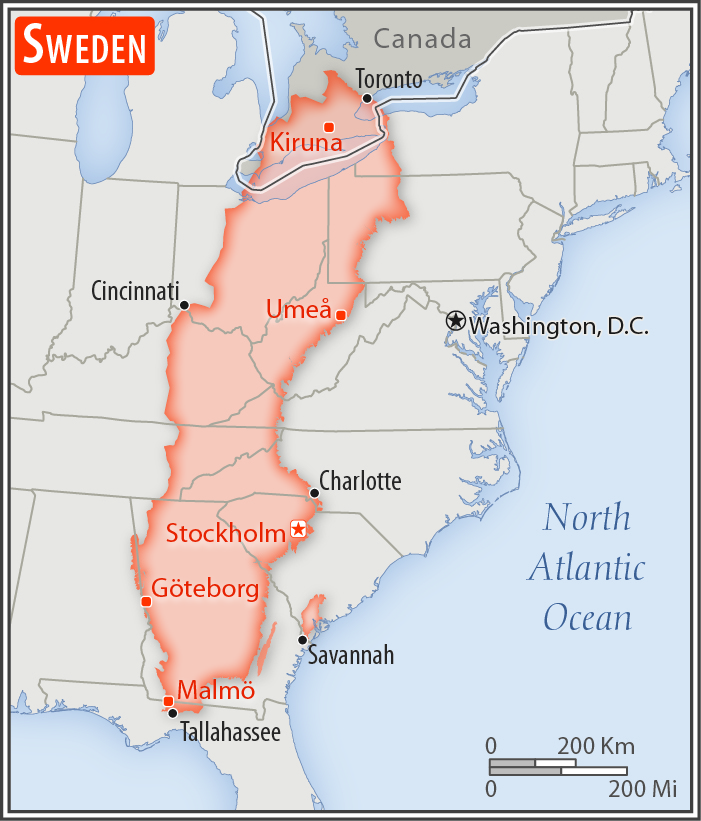
Area - comparative:
almost three times the size of Georgia; slightly larger than California
Area comparison map:
almost three times the size of Georgia; slightly larger than California
Land boundaries:
total: 2,211 km
[see also: Land boundaries - total country ranks ]
border countries (2):
Finland 545 km, Norway 1666 km
Coastline:
3,218 km
[see also: Coastline country ranks ]
Maritime claims:
territorial sea: 12
nm (adjustments made to return a portion of straits to high seas)
[see also: Maritime claims - territorial sea country ranks ]
exclusive economic zone:
agreed boundaries or midlines
[see also: Maritime claims - exclusive economic zone country ranks ]
continental shelf:
200-m depth or to the depth of exploitation
[see also: Maritime claims - continental shelf country ranks ]
Climate:
temperate in south with cold, cloudy winters and cool, partly cloudy summers; subarctic in north
More Climate Details
Terrain:
mostly flat or gently rolling lowlands; mountains in west
Elevation:
mean elevation: 320 m
[see also: Elevation - mean elevation country ranks ]
lowest point:
reclaimed bay of Lake Hammarsjon, near Kristianstad -2.4 m
highest point:
Kebnekaise 2,111 m
Natural resources:
iron ore, copper, lead, zinc, gold, silver, tungsten, uranium, arsenic, feldspar, timber, hydropower
Land use:
agricultural land: 7.5%
(2011 est.)
[see also: Land use - agricultural land country ranks ]
arable land: 6.4%
(2011 est.)
[see also: Land use - arable land country ranks ]
permanent crops: 0%
(2011 est.)
[see also: Land use - permanent crops country ranks ]
permanent pasture: 1.1%
(2011 est.)
[see also: Land use - permanent pasture country ranks ]
forest: 68.7%
(2011 est.)
[see also: Land use - forest country ranks ]
other: 23.8%
(2011 est.)
[see also: Land use country ranks ]
Irrigated land:
1,640 sq km
(2012)
[see also: Irrigated land country ranks ]
Population distribution:
most Swedes live in the south where the climate is milder and there is better connectivity to mainland Europe; population clusters are found all along the Baltic coast in the east; the interior areas of the north remain sparsely populated
Natural hazards:
ice floes in the surrounding waters, especially in the Gulf of Bothnia, can interfere with maritime traffic
Environment - current issues:
marine pollution (Baltic Sea and North Sea); acid rain damage to soils and lakes; air pollution; inappropriate timber harvesting practices
Environment - international agreements:
party to:
Air Pollution, Air Pollution-Nitrogen Oxides, Air Pollution-Persistent Organic Pollutants, Air Pollution-Sulfur 85, Air Pollution-Sulfur 94, Air Pollution-Volatile Organic Compounds, Antarctic-Environmental Protocol, Antarctic-Marine Living Resources, Antarctic Treaty, Biodiversity, Climate Change, Climate Change-Kyoto Protocol, Desertification, Endangered Species, Environmental Modification, Hazardous Wastes, Law of the Sea, Marine Dumping, Ozone Layer Protection, Ship Pollution, Tropical Timber 83, Tropical Timber 94, Wetlands, Whaling
signed, but not ratified:
none of the selected agreements
Geography - note:
strategic location along Danish Straits linking Baltic and North Seas; Sweden has almost 100,000 lakes, the largest of which, Vanern, is the third largest in Europe
NOTE: 1) The information regarding Sweden on this page is re-published from the 2020 World Fact Book of the United States Central Intelligence Agency and other sources. No claims are made regarding the accuracy of Sweden Geography 2020 information contained here. All suggestions for corrections of any errors about Sweden Geography 2020 should be addressed to the CIA or the source cited on each page.
2) The rank that you see is the CIA reported rank, which may have the following issues:
a) They assign increasing rank number, alphabetically for countries with the same value of the ranked item, whereas we assign them the same rank.
b) The CIA sometimes assigns counterintuitive ranks. For example, it assigns unemployment rates in increasing order, whereas we rank them in decreasing order.
- Main Index
- 2020 Index
- Country Ranks
- Definitions
- Sweden Index 2020
- Sweden Main Index
- Introduction
- History
- Geography
- Climate
- Maps
- People
- Religion
- Government
- Gov. Leaders
- Flags
- Economy
- Energy
- Communications
- Transportation
- Airport Codes
- Military
- Transnational Issues
- Photos
- Advertise Here
- Feedback

This page was last modified 27-Jan-20