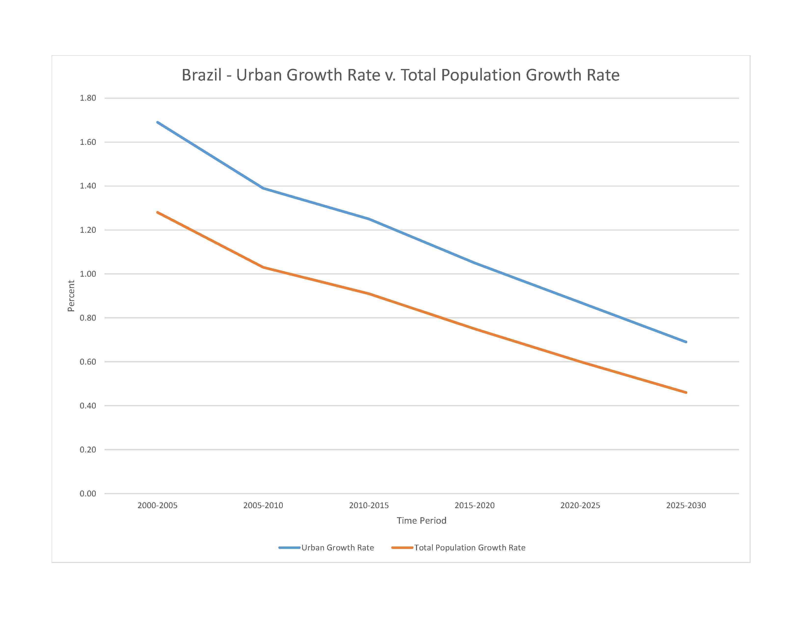
deforestation in Amazon Basin destroys the habitat and endangers a multitude of plant and animal species indigenous to the area; illegal wildlife trade; illegal poaching; air and water pollution in Rio de Janeiro, Sao Paulo, and several other large cities; land degradation and water pollution caused by improper mining activities; wetland degradation; severe oil spills
party to: Antarctic-Environmental Protection, Antarctic-Marine Living Resources, Antarctic Seals, Antarctic Treaty, Biodiversity, Climate Change, Climate Change-Kyoto Protocol, Climate Change-Paris Agreement, Comprehensive Nuclear Test Ban, Desertification, Endangered Species, Environmental Modification, Hazardous Wastes, Law of the Sea, Marine Dumping-London Convention, Nuclear Test Ban, Ozone Layer Protection, Ship Pollution, Tropical Timber 2006, Wetlands, Whaling
signed, but not ratified: Marine Dumping-London Protocol
mostly tropical, but temperate in south
agricultural land: 32.9% (2018 est.)
arable land: 8.6% (2018 est.)
permanent crops: 0.8% (2018 est.)
permanent pasture: 23.5% (2018 est.)
forest: 61.9% (2018 est.)
other: 5.2% (2018 est.)
urban population: 87.8% of total population (2023)
rate of urbanization: 0.87% annual rate of change (2020-25 est.)

0.62% of GDP (2018 est.)
0.01% of GDP (2018 est.)
particulate matter emissions: 10.94 micrograms per cubic meter (2019 est.)
carbon dioxide emissions: 462.3 megatons (2016 est.)
methane emissions: 401.83 megatons (2020 est.)
municipal solid waste generated annually: 79,889,010 tons (2015 est.)
municipal solid waste recycled annually: 1,118,446 tons (2014 est.)
percent of municipal solid waste recycled: 1.4% (2014 est.)
fresh water lake(s): Lagoa dos Patos - 10,140 sq km
salt water lake(s): Lagoa Mirim (shared with Uruguay) - 2,970 sq km
Amazon river mouth (shared with Peru [s]) - 6,400 km; Río de la Plata/Paraná river source (shared with Paraguay, Argentina, and Uruguay [m]) - 4,880 km; Tocantins - 3,650 km; São Francisco - 3,180 km; Paraguay river source (shared with Argentina and Paraguay [m]) - 2,549 km; Rio Negro river mouth (shared with Colombia [s] and Venezuela) - 2,250 km; Uruguay river source (shared with Argentina and Uruguay [m]) - 1,610 km
note – [s] after country name indicates river source; [m] after country name indicates river mouth
Atlantic Ocean drainage: Amazon (6,145,186 sq km), Orinoco (953,675 sq km), Paraná (2,582,704 sq km), São Francisco (617,814 sq km), Tocantins (764,213 sq km)
Amazon Basin, Guarani Aquifer System, Maranhao Basin
municipal: 16.13 billion cubic meters (2020 est.)
industrial: 9.51 billion cubic meters (2020 est.)
agricultural: 41.42 billion cubic meters (2020 est.)
8.65 trillion cubic meters (2020 est.)
total global geoparks and regional networks: 5
global geoparks and regional networks: Araripe; Cacapava; Quarta Colonia; Serido; Southern Canyons Pathways (2023)
NOTE: The information regarding Brazil on this page is re-published from the 2024 World Fact Book of the United States Central Intelligence Agency and other sources. No claims are made regarding the accuracy of Brazil 2024 information contained here. All suggestions for corrections of any errors about Brazil 2024 should be addressed to the CIA or the source cited on each page.
This page was last modified 04 May 24, Copyright © 2024 ITA all rights reserved.