draining of wetlands for agricultural use; deforestation; overgrazing; soil erosion; water pollution from industrial discharge and water hyacinth infestation in Lake Victoria; widespread poaching
party to: Biodiversity, Climate Change, Climate Change-Kyoto Protocol, Climate Change-Paris Agreement, Comprehensive Nuclear Test Ban, Desertification, Endangered Species, Hazardous Wastes, Law of the Sea, Marine Life Conservation, Nuclear Test Ban, Ozone Layer Protection, Ship Pollution, Wetlands
signed, but not ratified: Environmental Modification
tropical; generally rainy with two dry seasons (December to February, June to August); semiarid in northeast
agricultural land: 71.2% (2018 est.)
arable land: 34.3% (2018 est.)
permanent crops: 11.3% (2018 est.)
permanent pasture: 25.6% (2018 est.)
forest: 14.5% (2018 est.)
other: 14.3% (2018 est.)
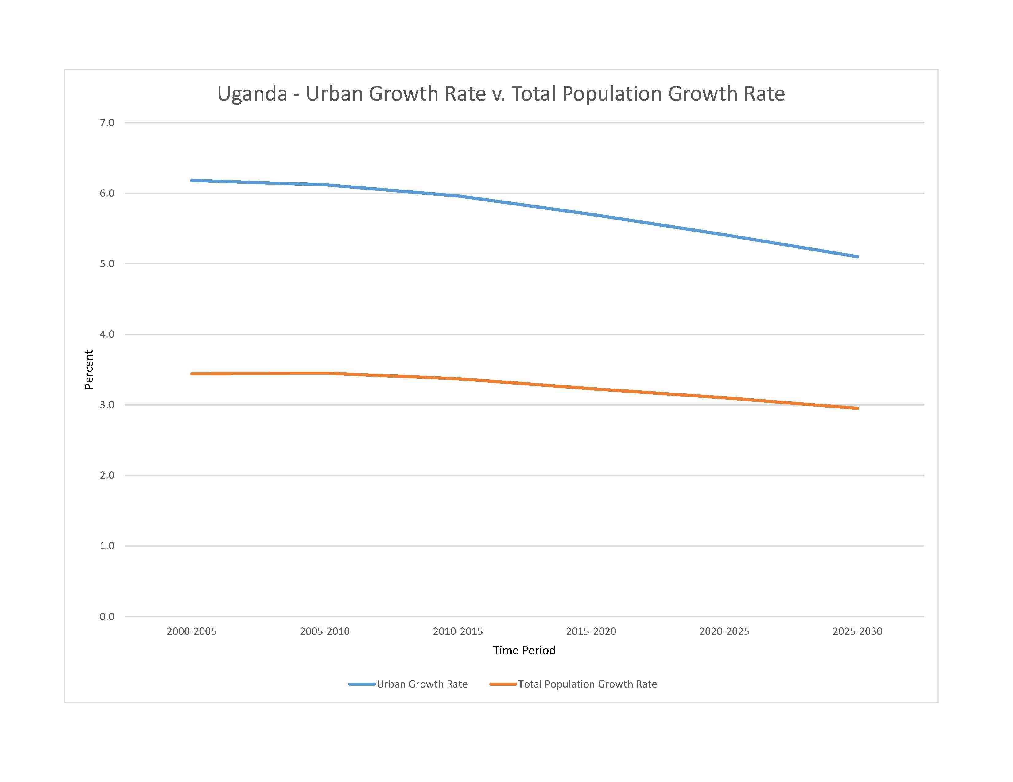
urban population: 26.8% of total population (2023)
rate of urbanization: 5.41% annual rate of change (2020-25 est.)

severe localized food insecurity:due to weather extremes, civil insecurity, and high food prices- in Karamoja Region, about 518,000 people, 41% of the population, are estimated to be severely food insecure between March and July 2022, as a result of consecutive poor rainy seasons that adversely affected crop and livestock production, frequent episodes of cattle rustling leading to the loss of productive assets, and high food prices (2022)
7.32% of GDP (2018 est.)
0% of GDP (2018 est.)
particulate matter emissions: 31.31 micrograms per cubic meter (2019 est.)
carbon dioxide emissions: 5.68 megatons (2016 est.)
methane emissions: 30.24 megatons (2020 est.)
municipal solid waste generated annually: 7,045,050 tons (2016 est.)
municipal solid waste recycled annually: 422,703 tons (2017 est.)
percent of municipal solid waste recycled: 6% (2017 est.)
fresh water lake(s): Lake Victoria (shared with Tanzania and Kenya) - 62,940 sq km; Lake Albert (shared with Democratic Republic of Congo) - 5,590 sq km; Lake Kyoga - 4,430 sq km; Lake Edward (shared with Democratic Republic of Congo) - 2,150 sq km
Nile (shared with Rwanda [s], Tanzania, South Sudan, Sudan, and Egypt [m]) - 6,650 km
note – [s] after country name indicates river source; [m] after country name indicates river mouth
Atlantic Ocean drainage: Congo (3,730,881 sq km), (Mediterranean Sea) Nile (3,254,853 sq km)
municipal: 330 million cubic meters (2020 est.)
industrial: 50 million cubic meters (2020 est.)
agricultural: 260 million cubic meters (2020 est.)
60.1 billion cubic meters (2020 est.)
NOTE: The information regarding Uganda on this page is re-published from the 2024 World Fact Book of the United States Central Intelligence Agency and other sources. No claims are made regarding the accuracy of Uganda 2024 information contained here. All suggestions for corrections of any errors about Uganda 2024 should be addressed to the CIA or the source cited on each page.
This page was last modified 04 May 24, Copyright © 2024 ITA all rights reserved.