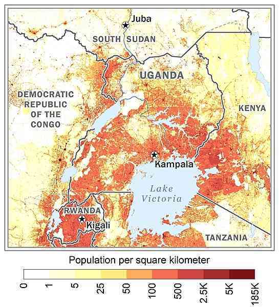
East-Central Africa, west of Kenya, east of the Democratic Republic of the Congo
1 00 N, 32 00 E
Africa
total: 241,038 sq km
land: 197,100 sq km
water: 43,938 sq km
slightly more than two times the size of Pennsylvania; slightly smaller than Oregon
total: 2,729 km
border countries (5): Democratic Republic of the Congo 877 km; Kenya 814 km; Rwanda 172 km; South Sudan 475 km; Tanzania 391 km
0 km (landlocked)
none (landlocked)
tropical; generally rainy with two dry seasons (December to February, June to August); semiarid in northeast
mostly plateau with rim of mountains
highest point: Margherita Peak on Mount Stanley 5,110 m
lowest point: Albert Nile 614 m
copper, cobalt, hydropower, limestone, salt, arable land, gold
agricultural land: 71.2% (2018 est.)
arable land: 34.3% (2018 est.)
permanent crops: 11.3% (2018 est.)
permanent pasture: 25.6% (2018 est.)
forest: 14.5% (2018 est.)
other: 14.3% (2018 est.)
105 sq km (2013)
fresh water lake(s): Lake Victoria (shared with Tanzania and Kenya) - 62,940 sq km; Lake Albert (shared with Democratic Republic of Congo) - 5,590 sq km; Lake Kyoga - 4,430 sq km; Lake Edward (shared with Democratic Republic of Congo) - 2,150 sq km
Nile (shared with Rwanda [s], Tanzania, South Sudan, Sudan, and Egypt [m]) - 6,650 km
note – [s] after country name indicates river source; [m] after country name indicates river mouth
Atlantic Ocean drainage: Congo (3,730,881 sq km), (Mediterranean Sea) Nile (3,254,853 sq km)
population density is relatively high in comparison to other African nations; most of the population is concentrated in the central and southern parts of the country, particularly along the shores of Lake Victoria and Lake Albert; the northeast is least populated as shown in this 
droughts; floods; earthquakes; landslides; hailstorms
landlocked; fertile, well-watered country with many lakes and rivers; Lake Victoria, the world's largest tropical lake and the second largest fresh water lake, is shared among three countries: Kenya, Tanzania, and Uganda
NOTE: The information regarding Uganda on this page is re-published from the 2024 World Fact Book of the United States Central Intelligence Agency and other sources. No claims are made regarding the accuracy of Uganda 2024 information contained here. All suggestions for corrections of any errors about Uganda 2024 should be addressed to the CIA or the source cited on each page.
This page was last modified 04 May 24, Copyright © 2024 ITA all rights reserved.