Southern Africa, east of Angola, south of the Democratic Republic of the Congo
15 00 S, 30 00 E
Africa
total: 752,618 sq km
land: 743,398 sq km
water: 9,220 sq km
almost five times the size of Georgia; slightly larger than Texas
total: 6,043.15 km
border countries (8): Angola 1,065 km; Botswana 0.15 km; Democratic Republic of the Congo 2,332 km; Malawi 847 km; Mozambique 439 km; Namibia 244 km; Tanzania 353 km; Zimbabwe 763 km
0 km (landlocked)
none (landlocked)
tropical; modified by altitude; rainy season (October to April)
mostly high plateau with some hills and mountains
highest point: Mafinga Central 2,330 m
lowest point: Zambezi river 329 m
mean elevation: 1,138 m
copper, cobalt, zinc, lead, coal, emeralds, gold, silver, uranium, hydropower
agricultural land: 31.7% (2018 est.)
arable land: 4.8% (2018 est.)
permanent crops: 0% (2018 est.)
permanent pasture: 26.9% (2018 est.)
forest: 66.3% (2018 est.)
other: 2% (2018 est.)
1,560 sq km (2012)
fresh water lake(s): Lake Tanganyika (shared with Democratic Republic of Congo, Tanzania, and Burundi) - 32,000 sq km; Lake Mweru (shared with Democratic Republic of Congo) - 4,350 sq km; Lake Bangweulu - 4,000-15,000 sq km seasonal variation
Congo river source (shared with Angola, Republic of Congo, and Democratic Republic of Congo [m]) - 4,700 km; Zambezi river source (shared with Angola, Namibia, Botswana, Zimbabwe, and Mozambique [m]) - 2,740 km
note – [s] after country name indicates river source; [m] after country name indicates river mouth
Atlantic Ocean drainage: Congo (3,730,881 sq km)
Indian Ocean drainage: Zambezi (1,332,412 sq km)
Upper Kalahari-Cuvelai-Upper Zambezi Basin
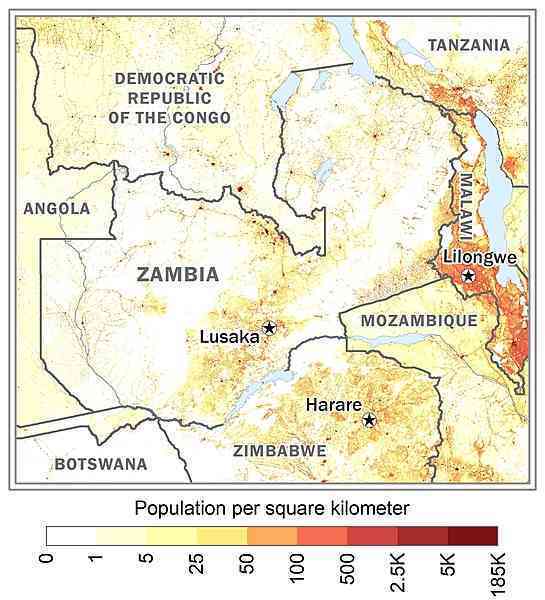
one of the highest levels of urbanization in Africa; high density in the central area, particularly around the cities of Lusaka, Ndola, Kitwe, and Mufulira as shown in this 
periodic drought; tropical storms (November to April)
landlocked; the Zambezi forms a natural riverine boundary with Zimbabwe; Lake Kariba on the Zambia-Zimbabwe border forms the world's largest reservoir by volume (180 cu km; 43 cu mi)
NOTE: The information regarding Zambia on this page is re-published from the 2024 World Fact Book of the United States Central Intelligence Agency and other sources. No claims are made regarding the accuracy of Zambia 2024 information contained here. All suggestions for corrections of any errors about Zambia 2024 should be addressed to the CIA or the source cited on each page.
This page was last modified 04 May 24, Copyright © 2024 ITA all rights reserved.